Huge swells to batter Southern Queensland
Tropical Cyclone Oma, currently a category 2 system is located west of Vanuatu and will gradually...
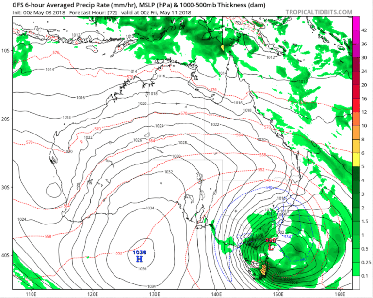
Southeastern Australia is about to cop a wintry blast as a cut-off low pressure system impacts the region mid-to-late this week.
Cut-off lows in Australia are defined as low pressure systems that have broken away and become displaced from the main belt of low pressure (and westerly winds) which lie to the south of the nation.
The system will be associated with temperatures more typical of mid-winter, highland snow, heavy rainfall and strong winds, and will be felt as early as Wednesday evening across Tasmania, southern Victoria and southeastern parts of South Australia. These conditions will then spread across the remainder of southeastern Australia throughout Thursday and Friday.
There is potential for the coldest temperatures this early in the year for several decades in some areas, with Melbourne struggling to reach 13-14 degrees on Thursday and Friday, Canberra 9 degrees on Friday, whilst Sydney will struggle to reach the high teens on Friday and Saturday. Wind chill will make it feel even colder than this.
Ample amounts of moisture will mean the ski resorts will see a significant dumping of snow, whilst snow will fall as low as 900 metres in New South Wales, which has potential to extend as far north as the Northern Tablelands (although less likely to settle).
The cold air will spread all the way up to Queensland, with the persistent humid, showery conditions on the coast of recent times set to be replaced by much drier westerly winds. Brisbane will chill below 10 degrees each night over the weekend (the coolest since September), whilst Mackay will dip into the low teens.
Depending on the formation of a surface low, there could also be significant rainfall, particularly across southern NSW, eastern VIC and eastern TAS where some models indicate potential for more than 50-100mm across several days.
Conditions will gradually improve from Sunday onwards as the system moves east and is replaced by a high pressure region.
Image: Synoptic chart and forecast precipitation for Australia at 00z Friday 11 May, 2018
Tropical Cyclone Oma, currently a category 2 system is located west of Vanuatu and will gradually...
A low pressure system and strong cold front moved through the South West Land Division of Western...
After a dry and warm start to spring, afternoon showers and storms were a welcome relief for many...