The Australian Tropical Cyclone season officially begins today
Australia’s Tropical Cyclone season has officially begun, running all the way through until April...
Tropical Cyclone Fina began earlier in the week as a tropical low and has now strengthened into a category 2 cyclone, arriving unusually early in the northern Australian cyclone season. With its track shifting south to south-west, meteorologists are cautioning that conditions for Darwin and the surrounding regions are looking more concerning today than they were even 24 hours ago.
Fina is forecast to move across the Van Diemen Gulf and approach the Top End later on Friday, with the most significant impacts expected into early Saturday. Its behaviour over the Gulf will be critical: warm waters, reduced land interaction, and a conducive atmospheric environment may allow the system to maintain or potentially deepen its intensity before its closest pass to Darwin.
Preparations are well underway, and timely, accurate information will be vital as the system approaches populated communities.
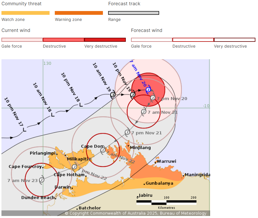
At 9.30pm (11pm AEDT) on Wednesday, TC Fina was a category 2 storm. (Bureau of Meteorology)
Cyclone Fina’s arrival is unusual for this point in the season. While we are officially in cyclone season, most years don’t see their first named cyclone until December, and sometimes even January. The Top End has only seen a handful of November cyclones over the past several decades, including Severe Tropical Cyclone Ines in 1973 and Cyclone Alessia in 2011.
As of Thursday morning, Fina sits offshore north-east of Cape Don, showing signs of a slow, deliberate turn towards the Northern Territory coastline.
Several scenarios remain possible, but EWN meteorologists highlight the crossing of the Van Diemen Gulf as the decisive moment. According to EWN Senior Meteorologist Ben McBurney,
“The system’s track over warm waters can help sustain intensity, and if Fina maintains strength, we could see damaging rainfall, flash flooding, and widespread water over transport corridors around Darwin. Today’s data suggests a worse outcome for Darwin than we were anticipating yesterday.”
BoM has issued a tropical cyclone warning for areas between Cape Don and Warruwi, including the Cobourg Peninsula, Minjilang, and parts of the Tiwi Islands. Communities within this zone may experience destructive wind gusts of up to 135–155 km/h from Friday as Fina nears land.
Darwin is currently outside the destructive wind core, but gale-force winds remain likely across the weekend, particularly if the system’s southern turn tracks closer to the mainland. This includes potential gusts strong enough to bring down weakened trees, damage loose structures, cut power, and place strain on emergency responders.
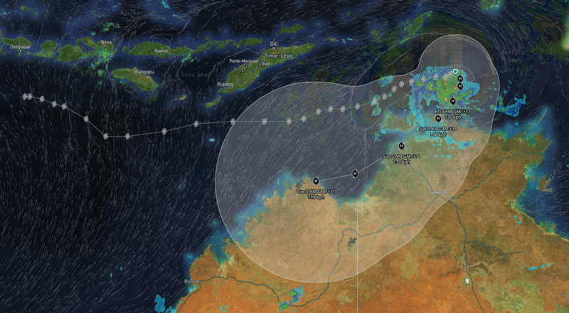
TC Fina historic track and projected path from tomorrow.io, 20/11/2025
While destructive winds grab the headlines, the most consistent threat Fina poses to Darwin and the Tiwi Islands is rain. EWN’s modelling aligns with BoM’s forecast of intense rainfall bands forming south of the cyclone’s centre as it interacts with coastal and inland terrain. These bands may bring:
Flash flooding in low-lying urban areas
Water across major roads and minor highways
Rail line inundation, particularly across flood-prone sections approaching Darwin
Rapidly rising creeks and drains, especially around coastal suburbs and outlying communities
Storm surge impacts along exposed coastlines
The Kakadu region is already seeing water levels rise, with Cahills Crossing closed as of Wednesday due to fast-moving, crocodile-inhabited floodwaters.
For Darwin, heavy rain may begin as early as Friday afternoon, increasing into Saturday as the cyclone approaches its nearest point.
Storm tide impacts could be severe across the Tiwi Islands, Cape Hotham, Maningrida, and surrounding communities. BoM has warned that tides may rise significantly above normal high tide levels, with damaging waves and dangerous coastal flooding possible.
For exposed coastal regions near the Van Diemen Gulf, these impacts can occur even if Fina does not make a direct landfall on the mainland.
EWN meteorologists and analysts are closely monitoring several key indicators as Fina approaches:
As the cyclone enters the Van Diemen Gulf, its behaviour will shape impacts for Darwin. Warm waters may support sustained intensity.
A slower-moving system increases rainfall totals, and consequently, the risk of flash flooding and transport disruption.
Recent modelling shows a subtle shift south-west, increasing the risk of more direct impacts to the Greater Darwin region.
Rainbands extending well south of the cyclone centre may deliver significant rainfall even without a direct landfall.
As Tropical Cyclone Fina approaches the Northern Territory, Early Warning Network will continue delivering real-time, locally verified intelligence to help protect communities, infrastructure, and emergency operations across the Top End.
Our meteorology and hazard monitoring teams are working closely with partners, emergency services, and local councils to ensure timely situational awareness as conditions evolve.
Australia’s Tropical Cyclone season has officially begun, running all the way through until April...
Tropical Cyclone Zelia is poised to become one of the most significant weather events of the...