Understanding Cyclone Kirrily: What You Need to Know
As the tropical low in the Coral Sea intensifies, it's crucial for residents in eastern Queensland...
A change in fortune has seen drought-stricken parts of Western Australia’s southwest on the receiving end of a series of powerful fronts.
These frontal systems have produced intense thunderstorm activity, damaging and destructive wind gusts, much-welcomed heavy rainfall, large hail, and the odd tornado.
After what seemed like an endless period of monotonous weather for Perth and surrounding areas, many people wondered: Who turned the severe weather switch on? Here, we take a look at the drivers behind the change.

Rainfall Analysis - week ending 3rd June 2024. Image via Bureau of Meteorology
Southern Annual Mode (SAM)
The Southern Annular Mode (SAM) is a climate driver that refers to the north-south movement of the strong westerly winds that blow in the mid to high latitudes of the Southern Hemisphere and are associated with systems such as lows and cold fronts. It also has three phases - neutral, positive and negative - but unlike the IOD and ENSO, which last for months at a time, SAM phases tend to last, on average, one or two weeks. Variations in SAM can explain up to ~15% in weekly rainfall variances, comparable to ENSO and the IOD.
Its influences are most pronounced in summer and winter, when the belt of westerly winds is at its southernmost or northernmost, respectively. In winter, negative phases are characterised by increased rain and wind across southwest Western Australia, southeast South Australia, Victoria, southern New South Wales, and Tasmania. However, reduced rainfall occurs across much of NSW and Queensland during negative phases. A positive phase in winter generally has reduced rainfall across southern Australia but increased rainfall over the north QLD coast and some parts of inland NSW and QLD.
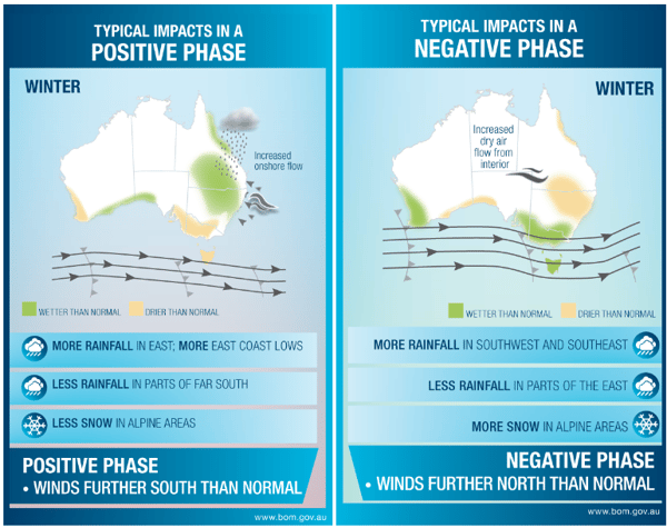
Southern Annual Mode in Winter. Image via Bureau of Meteorology
In summer, a negative SAM means generally dry weather for much of eastern and southeast Australia, except for western Tasmania. If conditions have been dry, this can help fuel bushfires. Meanwhile, a positive SAM phase in summer can mean increased rainfall across the eastern half of Australia due to increased onshore winds.
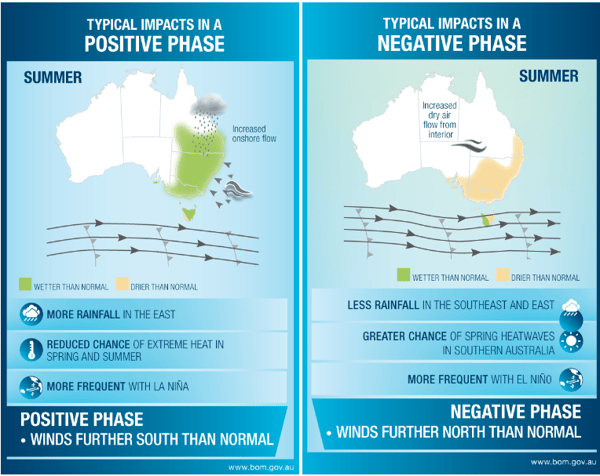
Southern Annual Mode in Summer. Image via Bureau of Meteorology
In WA's case, a continued positive trend in the Southern Annular Mode kept frontal systems well to the south of Australia, with a series of high-pressure systems dominating southern Australia.
During the first week of May, the SAM dipped into negative territory for the first time since mid-April. This negative dip in the Southern Annular Mode enabled frontal systems to shift further north, helping to generate unsettled weather for the state.
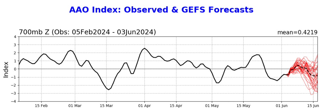
Observed and forecast Southern Annual Mode.
A large thunderstorm outbreak occurred on May 10th, with a tornado impacting the South Bunbury region. Despite SAM heading back into a positive phase towards mid-May, it rapidly dropped into a negative phase again by the end of the month. A series of powerful fronts have ensued.
The Jetstream
Secondly, the subtropical and polar Jetstreams that circulate the globe from west to east have been in what is known as a "split flow pattern". As the name suggests, the flow of these streams is divided. The subtropical jet has been meandering through central Australia, while the polar Jetstream has been operating south of Australia. Over the last couple of weeks, these jets have begun merging across Western Australia.
The polar jet, which is caused by temperature contrasts between polar and tropical airmasses, has shifted north in recent weeks as the SAM dipped into negative territory, allowing this belt of westerly winds to shift north. This northward shift has allowed cold air from Antarctica to shift north.
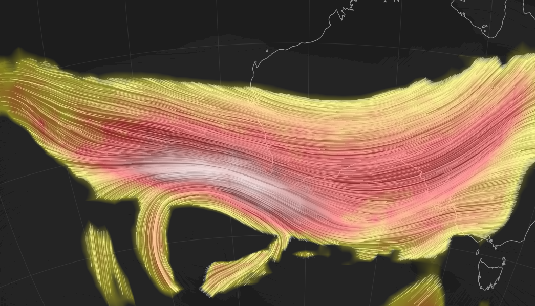
Forecast jetstream across Western Australia 9th June 2024. Image via Netweather.tv
The subtropical jet resembles the polar jet; however, it has a different thermal structure. It is strongest during the winter months and plays a key role in transporting tropical moisture southward into central Australia (as noted by last week’s northwest cloud band). This advection of moisture is also known as an atmospheric river.
As the polar jet shifts north, it interacts with and merges with the subtropical jet. This merger tends to increase the vertical up motion of air, thus increasing the risk of severe weather.
Last Wednesday to Friday, a monstrous northwest cloud band developed through WA; with the Jetstream merger, moisture-laden air in the Indian Ocean was dragged southeast to Australia, leading to widespread rainfall from the Kimberley in WA to Tasmania. This cloud band spanned over 4000km in length as it traversed the entirety of the country.
Indian Ocean Dipole (IOD)
In recent months, the Indian Ocean Dipole has been in a neutral phase (there are three phases: positive, negative, and neutral). The IOD doesn’t have much effect on southwestern WA, but it significantly influences northwest cloud bands when they are in a negative phase. However, being neutral at the moment, its effects are minimal.
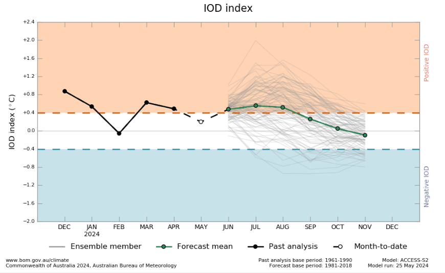
Indian Ocean Dipole - dropping into a neutral phase. Image via Bureau of Meteorology
Sea Surface Temperatures (SST)
Although it doesn’t seem all that significant, Sea Surface Temperatures (SST) and Ocean currents can significantly enhance severe weather. Warmer water holds more moisture, increasing the threat of enhanced rainfall under the right conditions. The warming of sea surface temperatures (SST) is mainly due to the Leeuwin current, which runs north to south off the WA coastline. This current drags warm ocean water south, raising ocean temperatures.
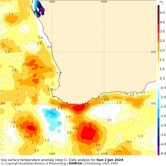
Current Sea Surface Temperatures (SST) anomaly off the WA coastline. Image via Bureau of Meteorology
The high-pressure anomalies across most of the country continued to fuel drought conditions across southwestern Western Australia. April, in particular, registered up to 7 hectoPascals (hPa) above average. This anomaly began shifting east into May.
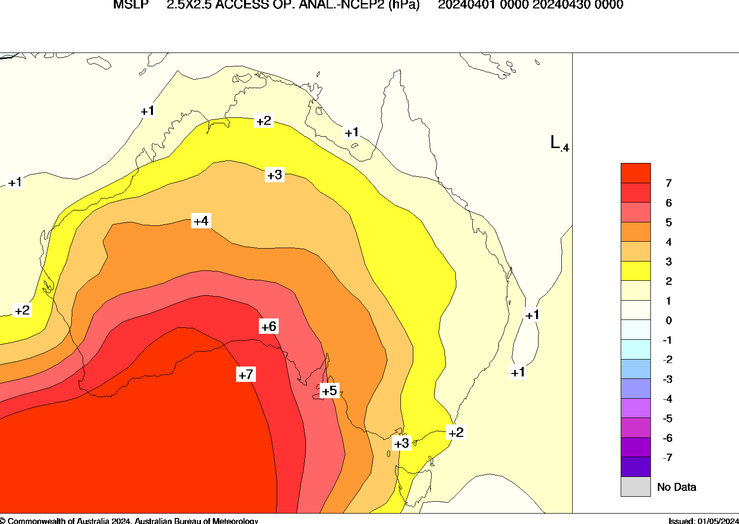
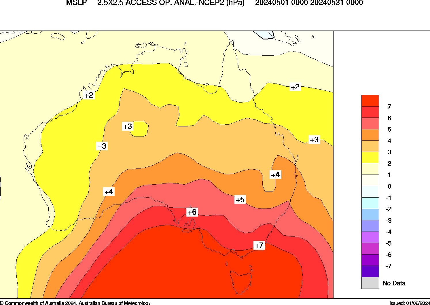
High-pressure surface anomalies for April and May. Image via Bureau of Meteorology
Numerous factors have been involved in the increased severe weather threats across Western Australia in recent weeks. The outlook for the next 7-10 days is remarkably similar. Another series of strong cold fronts will traverse the region, bringing severe thunderstorms, hail, damaging winds, isolated tornadoes, and heavy rainfall, leading to flash flooding.
The South West Land Division desperately needed significant rainfall—that, at least, is one positive aspect emerging from a destructive phase.
As the tropical low in the Coral Sea intensifies, it's crucial for residents in eastern Queensland...
The Early Warning Network is proud to announce a new Corporate Partnership with Bush Heritage...
Twenty-six years ago, on the evening of April 14, 1999, Sydneysiders watched in awe as a seemingly...