Climate risk and downstream impacts
As reported on news.com.au, supermarket giants Coles and Woolworths have announced new, temporary...
After a drier than average autumn across most of Australia, welcome winter rainfall will fall across inland NSW, Victoria, and eastern parts of South Australia this week.
Rainfall was around 70% below average during May, making it one of Australia’s driest on record since 1900. Despite the lack of rainfall, Australia experienced one of its coolest autumns in nearly a decade as minimum temperatures plummeted across the country.
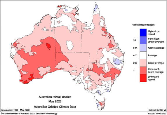
Rainfall deciles for May 2023 showing very much below average to lowest on record for vast areas of Australia. Image courtesy of Bureau of Meteorology.
This drier than average autumn has contributed to a rapid drying of soil moisture across large swathes of Queensland, NSW, Victoria, and eastern South Australia (including the Murray-Darling basin) despite seeing nearly three years of wetter than-average conditions and flooding.
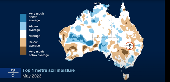 Bureau of Meteorology soil moisture map, indicating average to very much below average soil moisture for NSW and northern Victoria, including the Murray-Darling basin.
With a drier than average winter outlook expected for the majority of Australia, the upcoming potential for accumulated rainfall totals of 30-60mm across western NSW, Victoria, and eastern South Australia will be greatly appreciated, particularly for the agricultural industry. Despite agricultural growers becoming increasingly resilient to drought conditions and crop growth, a dash of early-winter rainfall will give a wonderful boost to several cropping areas, including wheat, barley, oats, and triticale.
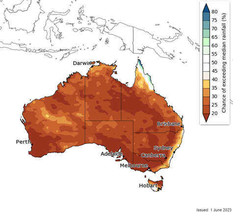 Bureau of Meteorology 3-month chance of above rainfall outlook from June to August 2023, indicating below-average rainfall expected across Australia.
The Early Warning Network’s Climatics platform highlights a slight decrease in winter rainfall across southeastern Australia. The Winter 3-monthly historical data dating from 1991 to present showcases this gradual decline of seasonal rainfall compared to the 30-year average (1961–1990).
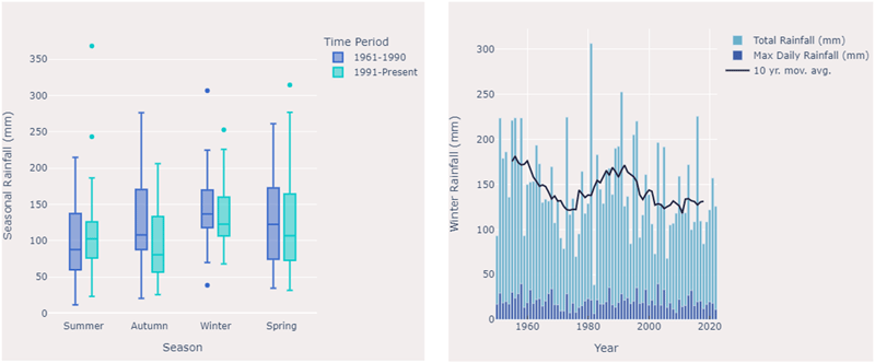
EWN's Climatics platform showing a slight decrease in winter rainfall across southeastern Australia. Plot shows data for Shepparton in northern Victoria.
Widespread light to moderate rainfall will develop during Monday and into Tuesday due to an inland trough, with a more substantial low and associated trough moving through Wednesday into Thursday generating the heaviest falls for the week. Widespread accumulated rainfall totals of 30-60mm can be expected, with isolated higher falls of 80-100mm. Pockets of flash flooding may be generated by rainfall of this nature.
For far western and northwestern parts of NSW, the threat of a severe thunderstorm or two will develop during Monday afternoon. Should this threat materialise, a damaging wind and large hail (2-3cm) threat is expected. Another bout of severe storms will develop along the main trough line in South Australia during Wednesday afternoon before spreading into areas of rain as it enters western NSW and Victoria. Damaging winds and large hail may accompany these thunderstorms.
Large hail of this nature can produce damage to cars, with hire car organisations, new and used car yards expected to be impacted with the passage of severe storms across eastern South Australia on Wednesday. Damaging winds could also lead to downed trees and powerlines, which would cause power outages for many businesses and residents throughout the region.
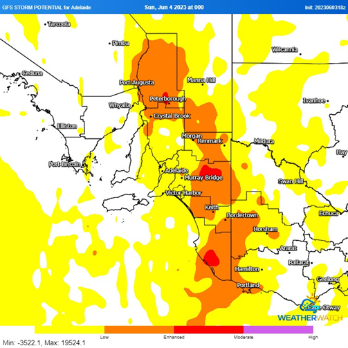
GFS storm potential for midday Wednesday 7th June 2023. Image courtesy of Weatherwatch.
Tools will be down for tradesmen and women on construction and housing sites this week, particularly for those working outside, along with poor conditions for concreters attempting to pour slabs for housing foundations, driveways, and larger building constructions.
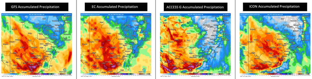
6-day accumulated rainfall totals as predicted by four weather models (GFS, EC, ACCESS-G and ICON) indicating widespread falls of 30-60mm with pockets of higher totals approaching 100mm. Images courtesy of Weatherwatch.
Explore EWN's Climatics or contact us for more information about how our forecasting services can help your business.
As reported on news.com.au, supermarket giants Coles and Woolworths have announced new, temporary...
The Great Ocean Road is one of Victoria’s greatest attractions and achievements. Indeed, it’s also...
Tropical Cyclone Zelia is poised to become one of the most significant weather events of the...