Australia’s May–July 2025 Weather Outlook
As we transition into the cooler half of the year, the Bureau of Meteorology (BoM) has released its...
As Australia transitions from summer to autumn, it's essential to reflect on the recent climatic changes and prepare for what's ahead. Contrary to the initial dry forecasts, the summer brought above-average rainfall to most of Australia, providing much-needed relief to several regions. However, the far western and southwestern parts of Western Australia (WA) remained exceptions, experiencing drier conditions. As we make this transition into cooler weather, the Seasonal Bushfire Outlook for Autumn 2024, released today by AFAC, the National Council for fire and emergency services, offers crucial insights into the upcoming season.
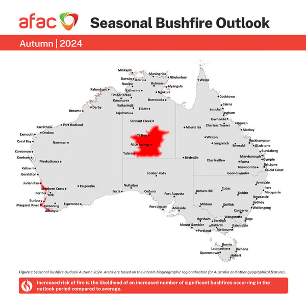
AFAC Autumn Bushfire Outlook (via AFAC)
Recent Climate Conditions and Their Impact on Bushfire Risks
The period from August to October 2023 was marked as Australia's driest three months on record, setting a challenging stage for bushfire conditions. However, a significant turnaround occurred from November 2023 to January 2024, with most of the country experiencing above-average rainfall, marking it as the 18th wettest period in 124 years. As we noted above, this shift was not uniform across the continent; parts of far western and southwestern Western Australia continued to experience severe dryness, receiving less than 10 mm of rainfall over three months, highlighting the stark regional disparities in climate impact.
February's climate further underscored this variability, with areas extending from the Gulf of Carpentaria through to central New South Wales receiving above-average rainfall and flooding, thanks to ex-Tropical Cyclones. Conversely, much of the south and west of the country, saw below-average rainfall, exacerbating dry conditions. Soil moisture levels mirrored this pattern, with significant parts of the country reporting above-average levels, while coastal and southern Western Australia, the southern Northern Territory, and eastern Tasmania faced below to very much below average soil moisture, amplifying the bushfire risk in these regions due to the drier vegetation.
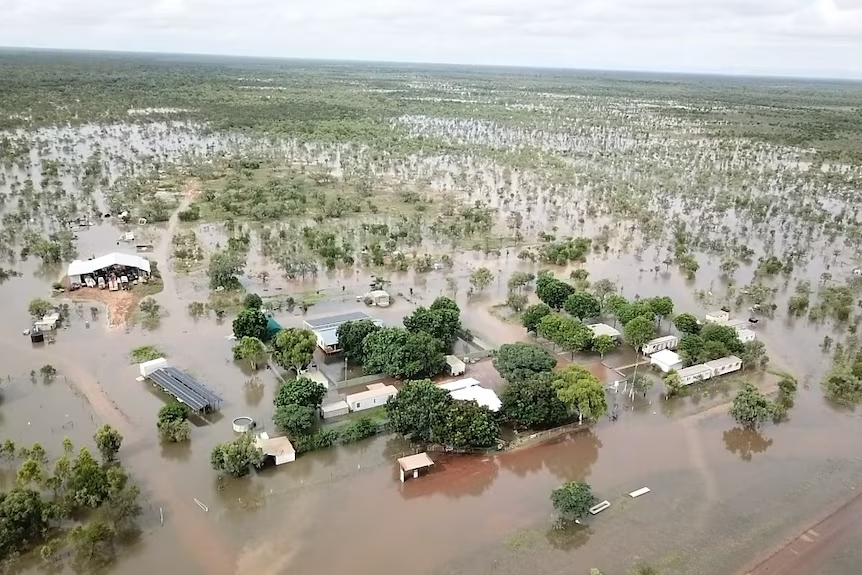 The Tirranna Springs Roadhouse at Gregory was inundated.(Image: ABC News from Jil Wilson)
Autumn Forecast: A Season of Warmth and Risk
Autumn is expected to continue the trend of warmer temperatures across the country, with maximum and minimum temperatures likely to be above the median. This warmth, however, comes with a caveat - the likelihood of below-median rainfall across vast areas of northern, eastern, and southwestern Australia.
In Victoria, the summer's above-average rainfall, especially significant in the north, has led to much wetter soils than usual for this time of year, reducing the availability of fuel in most forests and decreasing the curing levels in grasslands. This has resulted in less bushfire activity than average, although the potential for increased fire activity remains in the drier heathy forests and woodlands due to forecasted drier conditions, as has been seen in recent fire activity over the last couple of weeks. Tasmania, on the other hand, experienced few significant fire weather events over the summer, with the eastern half of the state and the Bass Strait islands facing high soil moisture deficits. Despite this, the overall fire season potential for Tasmania is considered normal, with the community urged to remain prepared for bushfires as significant fire weather could still occur in early autumn.
South Australia and Queensland both experienced milder summers than anticipated, with higher summer rains delaying harvest operations and increasing vegetation growth, respectively. In South Australia, the combination of below-average to average rainfall and potential for fuel curing (where live vegetation loses moisture and becomes dry, making it more flammable and susceptible to ignition) with above median maximum temperatures may slightly elevate fire dangers in specific districts early to mid-autumn. Queensland, meanwhile, anticipates normal bushfire potential across most of the state due to the high soil moisture content and significant vegetation growth, although a mid-autumn peak in fire activity is possible in the grassland regions of northern and central Queensland.
Western Australia and the Northern Territory faced hotter and drier conditions, with the South West Land Division (SWLD) of WA experiencing severe rainfall deficiencies and the NT witnessing extensive landscape wildfires over the summer. Both regions are bracing for an increased risk of bushfires during autumn, particularly in areas with elevated fuel loads, below-average soil moisture, and advanced curing.
This animation visualises October & November fires in the Northern Territory captured by DEAHotspots
The Role of the Early Warning Network
Throughout the volatile summer, our dedicated team at the Early Warning Network was constantly vigilant, providing indispensable support to our customers through a series of bushfire alerts and forecasts. Amidst the backdrop of severe rain, flooding, and the onslaught of Tropical Cyclones, our team offered timely data, warnings, and alerts to ensure the safety and preparedness of communities. Our efforts underscored the critical importance of accurate, up-to-the-minute information in mitigating the impacts of these extreme weather events.
As we transition into autumn, with some of its unique set of challenges outlined in this post, our commitment to safeguarding our customers remains strong. Leveraging advanced forecasting technologies and a deep understanding of Australia's diverse climate landscape, we will continue delivering the vital alerts and insights that our customers rely on. Whether facing the risk of bushfires in susceptible regions or preparing for other severe weather conditions, the Early Warning Network is dedicated to providing the support needed to navigate the season ahead with confidence and resilience.
If you'd like to join the Early Warning Network, chat to our team today.
As we transition into the cooler half of the year, the Bureau of Meteorology (BoM) has released its...
While it may be hard to believe after this week's severe storms and flooding that have ravaged much...
As summer comes to an end, we reflect on the major weather events that shaped Australia over the...