Another bout of extreme to locally catastrophic will develop across parts of South Australia and Victoria on Wednesday as a surface low and cold front traverses southeastern Australia.
Strong north-to-northwesterly winds around 60-80km/h will develop ahead of, and in the wake of this front on Wednesday. Isolated damaging wind gusts of 90km/h are also possible across higher terrain of western Victoria and eastern South Australia.
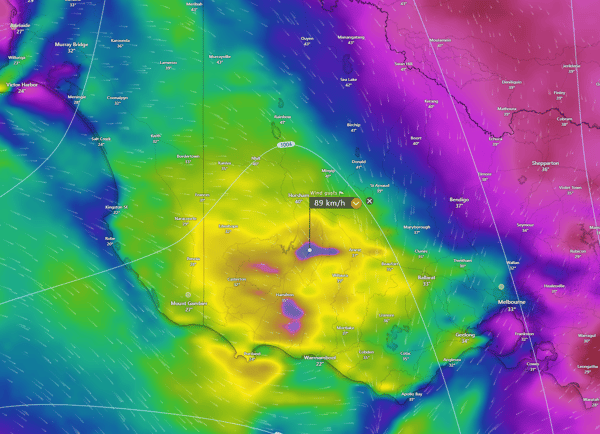
Potential wind gusts for Wednesday afternoon. Image via Windy.com
Temperatures will again soar across the region, with many towns expected to see temperatures in the high 30s to low 40s. Mildura, in the far northwest of Victoria, is expecting a top of 44°C Wednesday, Swan Hill 42°C, Hopetoun 42°C, Kerang 40°C, and Charlton 41°C. Further west into South Australia, Renmark is expected to reach 44°C, Loxton 43°C, and Murray Bridge 37°C.
Despite wetter-than-average conditions leading into the start of 2024, drier-than-average conditions have taken a stranglehold on western Victoria since late January. Horsham Aerodrome and Stawell are now into their 31st consecutive day without rainfall, with 0.4mm and 3mm falling back on January 27th. Despite this, their monthly rainfall for January was nearly double the average. This run of hot and dry conditions has led to a rapid drying of vegetation that quickly grew in response to spring and early summer rainfall.
Stawell is on track to see its first rainless month in over a decade, with January 2013 being the last month with zero rain falling into the rain gauge. Should Stawell see no rain for the rest of this month, it will equal its driest February on record, which saw 0mm recorded in February of 1991.
Intense heat, gusty winds, and continued dry conditions will see a large swathe of extreme fire danger on Wednesday across parts of eastern South Australia and western Victoria, with catastrophic conditions expected for the Wimmera fire forecast district. This region will be a significant focus on Wednesday, with a sizeable 20,000-hectare fire continuing to burn out of control. Winds will shift westerly during the late afternoon in the wake of this front, potentially spreading this fire rapidly in an easterly direction while likely enhancing the size of the fire front.
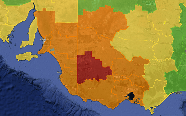
Extreme to catastrophic fire danger for parts of SA, VIC, and NSW on Wednesday. Image via EWN.
To make matters worse, a threat of one or two isolated high-based thunderstorms could develop along the axis of this cold front during Wednesday afternoon. If any storms develop, there will be a locally damaging wind threat in the form of microbursts and a dry lightning threat. Dry lightning strikes could start separate fires, with strong outflow winds fanning these, making it nearly impossible to halt under such conditions.
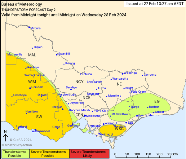
Thunderstorm potential for Victoria during Wednesday. Image via BoM
Meanwhile, a cluster of fires continue to burn across the Central Highlands region of Tasmania. Although these fires have now been downgraded to an advice, an elevated fire threat will redevelop for Tasmania on Wednesday as above-average temperatures and gusty north-to-northeasterly winds develop ahead of this low and cold front.
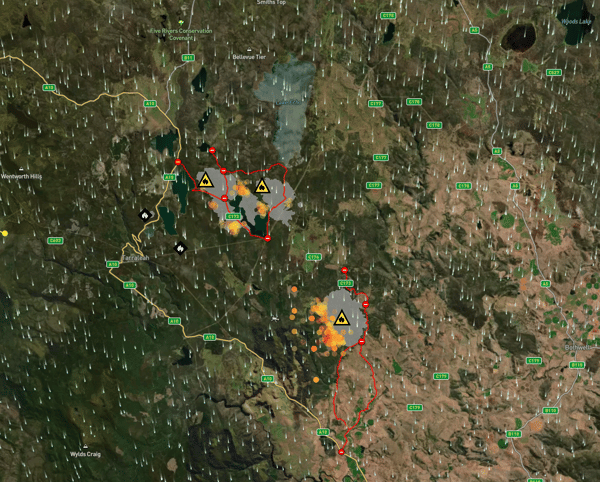
A cluster of fires continues to burn through central Tasmania. Image via Bushfire.io
During the summer of 2023/24, Australia faced significant bushfire challenges across various states, exacerbated by heatwave conditions and the impact of an El Niño weather event. Notably, in New South Wales (NSW), over 50 fires were active during a mid-December heatwave, with Sydney and many other areas under a total fire ban. The state mobilised more than 700 firefighters and incident management personnel to combat the widespread high and extreme fire danger.
The extreme weather conditions early in the season, with temperatures soaring above average, heightened the risk of bushfires across the country. This season was particularly concerning as authorities warned of a high-risk bushfire season, following two relatively quiet seasons since the devastating "Black Summer" fires of 2019-2020. As the season progressed, the number of bushfires on the east coast eased as thunderstorms, cyclones and humidity, however fires in Western Australia have continued to burn throughout summer.
Our team has been alerting customers to bushfire alerts and watch & acts throughout the summer, which, thankfully, was not as bad as originally predicted, EWN staff and authorities are poised for a busy end to the 2023/24 bushfire season.
If you would like to talk to our team about how we can help your business prepare for severe weather, please contact us.
Recent Articles
The Australian Tropical Cyclone season officially begins today
Australia’s Tropical Cyclone season has officially begun, running all the way through until April...
2023–24 severe weather outlook
As summer unfolded in the Northern Hemisphere, Australians observed with growing concern the series...