From drought to destructive thunderstorms - The reasons behind WA's sudden change in weather fortune
A change in fortune has seen drought-stricken parts of Western Australia’s southwest on the...
Parts of WA’s southwest coast experienced tempestuous conditions over the weekend as a vigorous cold front impacted the region.
A line of severe thunderstorms rapidly developed along the front on Saturday night, delivering damaging winds, heavy rainfall, and pockets of isolated large hail. Over 10,000 properties were without power early Sunday morning due to widespread minor to moderate wind damage, with Firefighters from Perth and Daglish stations called out to rescue people from lifts at three different buildings on Adelaide Terrace, Pier Street and Hay Street. The outages also caused widespread issues with CCTV networks and parking machines.
 Water vapour satellite imagery over the last 24 hours showcases WA's vigorous cold front and storm activity.
An isolated, dangerous storm developed ahead of the main line and remained unimpeded as it barrelled through Dawesville to the south of Brunswick. The highly sheared environment and modest instability kept the storm well-organised for a long time, bringing damaging winds and large hailstones. The Brunswick area was hit particularly hard with reports of very large hail.
Damaging winds were a common hazard as the main line of showers and thunderstorms swept through the region overnight. Powerful winds just above the surface were dragged down, with some of this activity bringing gusts over 100km/h. The Bunbury Parade Hotel suffered extensive damage, with suspicions of a possible waterspout coming ashore. Notable gusts from the event include 102km/h at North Island, 91km/h at Garden Island, 102km/h at Rottnest Island, 91km/h at Busselton and 93km/h at Armament Jetty.
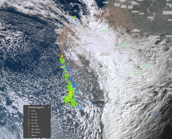
Widespread rainfall totals of 25-55mm were recorded across southwestern WA.
Despite some flash flood concerns, most in the southwest district welcomed heavy rainfall. Widespread rainfall accumulations of 25-55mm were recorded, further alleviating the stress associated with the drought-stricken region. Notable observations were 29.2mm in 30 minutes recorded at Wilyabrup and 54.6mm in 5 hours recorded at Donnybrook East up to 03:00 WST. Further shower activity continued yesterday in the wake of the cold front delivering a few more millimetres.
A severe weather warning remained current for the coastal fringe between Mandurah and Albany, with damaging winds of up to 90km/h. Conditions eased later in the evening.
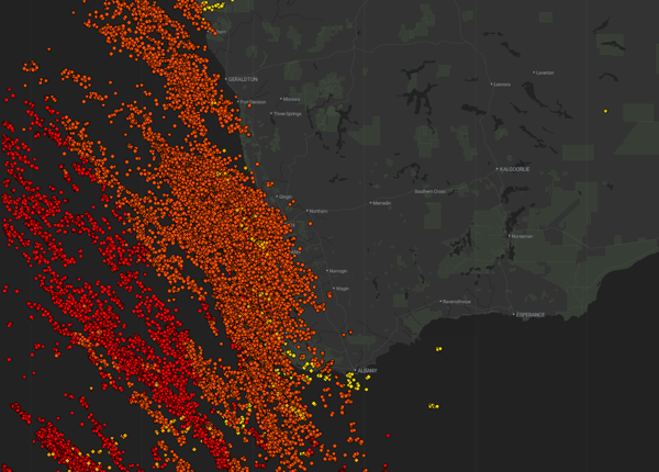
EWN's lightning tracker detected nearly 68,000 flashes from 8am Saturday.
Nearly 68,000 cloud-to-ground strikes and cloud-to-cloud pulses were detected since 8am yesterday morning.
A change in fortune has seen drought-stricken parts of Western Australia’s southwest on the...
As the tropical low in the Coral Sea intensifies, it's crucial for residents in eastern Queensland...
Parts of South-East Queensland have been lashed by severe thunderstorms over the last 24 hours,...