Inland Australia rejoices thanks to a widespread rainfall event
A large part of Australia had endured a very wet and stormy to start March, with some locations...
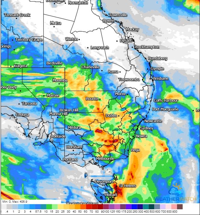
Image 1: Access G rainfall accumulation next 84hrs. Image via WeatherWatch.
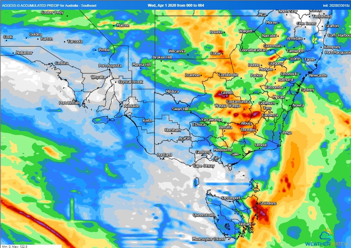
Image 2: Access G rainfall accumulation next 84hrs. Image via WeatherWatch.
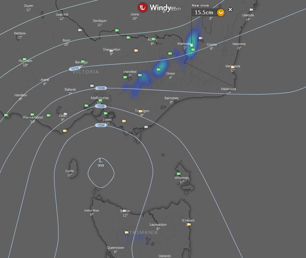
Image 3: EC snow forecast, next 10 days. Image via Windy.com
Parts of south-eastern Australia are set for a wet, stormy and cold start to April.
An upper trough, currently moving through eastern Western Australia and South Australia is generating a large band of cloud with showers, patchy rain periods and thunderstorms.
During Wednesday, this system will continue to shift east, generating scattered showers, light rain periods and isolated thunderstorms for parts of South Australia, western New South Wales, inland Queensland and northern Victoria.
Increasing moisture will be dragged down into central-inland parts of SA, where a belt of locally moderate falls may develop during Wednesday. The potential will exist for local falls up to 50mm, particularly with any storm activity.
During Thursday, this upper system is expected to deepen across the eastern states, generating a large region of cloud with showers, rain periods and embedded storm activity. Moderate to locally heavy falls may develop for southern NSW and north-eastern VIC, with widespread falls of 10-30mm likely, with isolated falls to 70mm possible over the next few days.
On Friday, a powerful low in the Southern Ocean and a vigorous cold front is expected to pass across southern Australia. This system is likely to generating another band of showers, rain periods and thunderstorms late Friday and into the weekend.
Locally damaging winds may develop during Friday for exposed coastal regions and higher terrain of SA, before shifting east Friday night and into Saturday for parts of VIC, TAS and NSW.
Cold and showery conditions will develop during Saturday, with temperatures likely to drop as much as 10 degrees for some locations. Small hail is likely with shower activity for parts of VIC and TAS on Saturday, with a dusting of snow expected for Alpine regions over the weekend,
Further details to follow over the coming days.
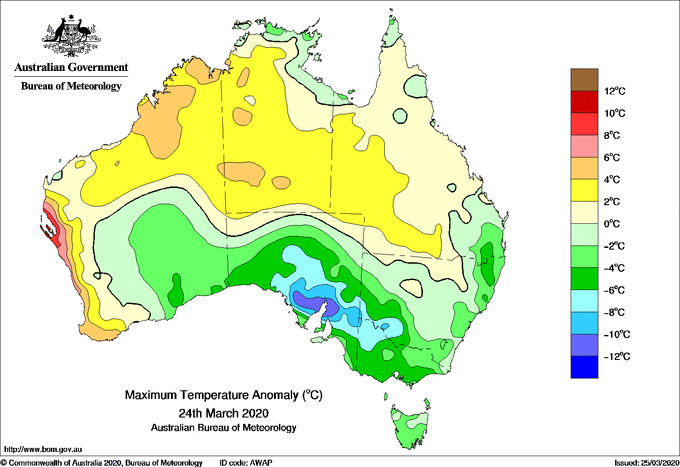
Image 1: Maximum temperature anomoly for Australia 24th March 2020
Some of the coldest March weather in decades has gripped southern Australia across the past five days as a slow-moving high pressure system has driven unseasonably cool southerly winds over the region.
After a strong cold front swept across the nation's south on Friday, temperatures have been more typical of mid to late April than late March, with many locations enduring several consecutive days of maximum temperatures 5-to-10 degrees below average, with some chilly nights mixed in as well.
In Melbourne, the past five days have averaged a maximum of just 17.84 degrees, the coolest five day stretch in March since 1988.
On Monday, parts of South Australia's west coast fell more than 10 degrees below average, with Streaky Bay seeing it's coldest March day on record (59 years of data), and Ceduna seeing its coldest March day since 1969.
Keith in southeast SA dropped to just 0.1 degrees this morning, more than 10 degrees below average for March and its coldest March night since 2008.
As a result of the chilly conditions, many areas are on track to see their coldest March in at least five years, some places potentially since 2005.
The cold spell has broken today, with many areas reaching into the 20s, with temperatures expected to climb into the high 20s to low 30s over the weekend ahead of another cold front.
This front will cross later on Sunday, causing temperatures to fall below average again over the final days of the month.
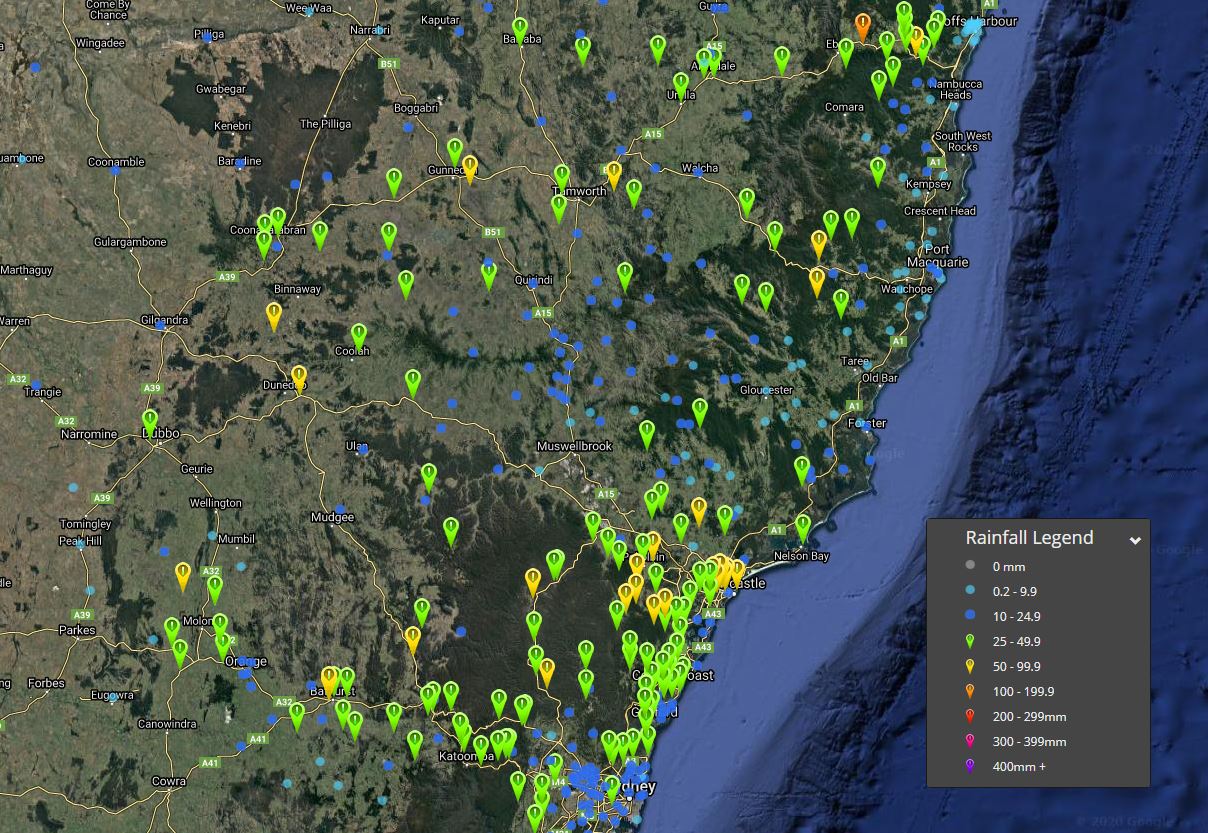
Image 1: EWN rainfall totals, 24 hours to 9am 26/03/2020
Widespread thunderstorm activity during Wednesday afternoon produce moderate to locally heavy falls across central and northern parts of NSW.
An upper trough and surface trough combined to produced an unstable airmass during Wednesday afternoon, with widespread shower and storm activity. A few of these storms became severe during Wednesday afternoon and were warned for damaging winds, large hail and heavy rain.
Across the Mid North Coast, Meldrum recorded 108mm, Thora Post Office picked up 55mm and Bellingen with 38mm.
Parts of the North West slopes and Plains also received moderate to locally heavy falls, with Mulla Crossing near Tamworth scoring 67mm, Ruvigne 66mm, Tamworth 43mm and Boggabri 39mm.
Heavy falls also developed across parts of the Hunter as a southerly change slowly moved up the NSW coast. Newcastle Tafe recorded 80mm to 9am this morning, with Nobbys Head scoring 69mm, Broadmeadow 65mm, Waratah Reservoir 62mm.
Other notable totals include, Bathurst 64mm, Ben Bullen 54, Bilpin 41mm, Canterbury 26mm, Nullo Mountain 38mm, Nelson Bay 37mm. Meanwhile, Coonamble Airport registered a 95km/h wind gust at 2:14pm Wednesday afternoon.
Further showers, patchy rain periods and isolated storms are expected across the NSW coast throughout Thursday and should slowly contract to the northern half of the state whilst easing.
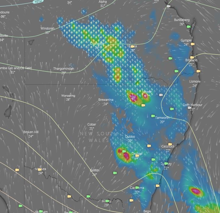
Image 1: EC rain and thunder Wednesday afternoon. Image via windy.com
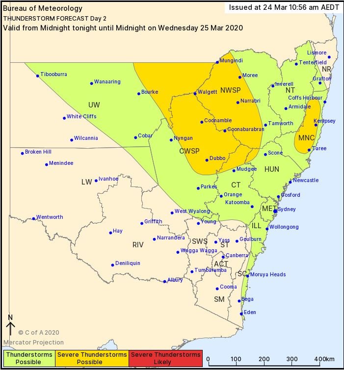
Image 2: BoM day 2 thunderstorm outlook, valid to midnight Wednesday 25/03/2020
Thunderstorm activity will return to inland parts of Queensland and New South Wales during Wednesday afternoon.
An upper trough will move across NSW and QLD during Wednesday, deepening a surface trough across inland parts of these states. To the east of this trough, an increasingly unstable airmass is expected to develop, leading to scattered showers and storms during the afternoon hours.
Across inland regions of NSW and QLD, clusters or lines of storms may develop and propagate east which may pose a damaging wind threat, along with the potential for locally heavy rainfall and hail.
Across eastern NSW, a southerly change will move up the coast, and may provide another focal point for afternoon thunderstorm activity. Whilst modest wind shear will be in place across eastern NSW, this southerly change may provide and area of enhanced lift. Any storms that can ride this boundary may become briefly severe with locally damaging winds, heavy rain that may lead to flash flooding and hail. However, some uncertainty exists around this scenario, depending on the timing of the change and cloud cover generated from the upper trough over the next 24 hours.
During Thursday, the southerly change is expected to move though northern NSW and southern QLD, with residual instability present across the Northern Tablelands region. This is expected to lead to a few showers and localised thunder.
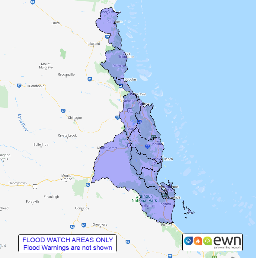
Image 1: EWN generated flood watch for North Queensland.
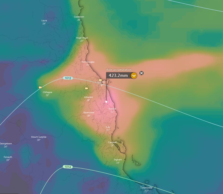
Image 2: EC rainfall accumulation next 5 days. Image via windy.com
Late this weekend, a coastal trough is expected to move towards the North Queensland coast, with showers, rain periods and isolated thunderstorms expected to develop.
24hour rainfall totals of up to 200mm are expected for coastal locations between Cooktown and Townsville, with heavier falls possible, particularly with convergence zones and thunderstorm activity.
A flood watch is current for rivers and creeks from Cooktown to Innisfail, with riverine flooding likely to develop late Sunday and into Monday in response to heavy falls.
This comes less than 2 weeks after the same catchments came under threat from heavy rain due to a developing tropical low.
The peak of the activity is expected overnight Sunday and into Monday, with further heavy rain periods expected to steadily ease into Tuesday.
Image 1: BoM Month to date rainfall totals. March 1st - March 18th, 2020.
Image 2: EWN rainfall totals, 24hrs to 9am 18/03/2020.
The South West Land Division of WA has experienced a very stormy last 4 weeks, with an impressive start to Autumn rainfall wise across the region.
In the 24hrs to 9am this morning, Perth recorded 19.8mm taking its March total to 28.4mm, making this their wettest March in 7 years, with nearly two weeks left.
During Tuesday, a cold front and upper cold pool of air swept across the South-West of the state, generating cold and blustery conditions with heavy showers and isolated storms.
Across the Lower West, Jarrahdale 2 picked up the heaviest falls to 9am this morning with 28mm, Bickley 27mm, Glen Eagle 26mm and Bungendore 25mm.
However, it was the South West that scored the highest falls, with Northcliffe scoring an impressive 42mm whilst Shannon registered 29mm.
Shower activity has now cleared with Perth region, with showers continuing across the South Coastal District this afternoon and evening. Gusty winds, bursts of rain and the potential for small hail are possible with this activity.
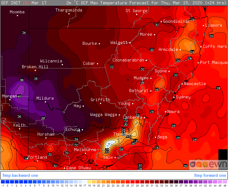
Image 1: OCF Forecast maximum for NSW and VIC on Thursday 19 March, 2020
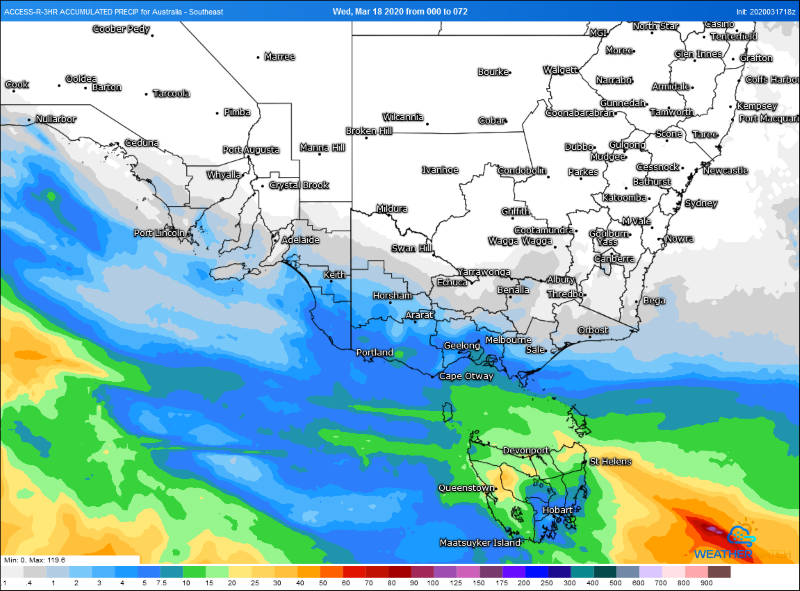
Image 2: Accumulated precipitation for the next 72 hours from the ACCESSR model (Source: Weatherwatch Metcentre)
Southeastern Australia is currently enjoying some mid-March warmth as temperatures reach push into the high 20s and low-to-mid 30s, however temperatures are set to plummet again from tomorrow afternoon as a cold front sweeps across the region.
After some of the coldest weather this early in the year for a number of years over the weekend, this week has been much warmer as temperatures push five to ten degrees above the average, with this warmth peaking today and tomorrow. Some parts around the SA/VIC/NSW border will push into the high 30s and possibly reach 40 degrees.
Ahead of the change, northerly winds are also increasing which is leading to higher fire danger with Severe Fire Danger for the West Coast of South Australia today. Tomorrow, Severe Fire Danger is likely over southern and eastern SA and into western Victoria.
The change will begin to sweep through southeastern parts of SA from Thursday afternoon, before pushing over Victoria and Tasmania during the late afternoon/evening and into Friday morning.
Showers and thunderstorms may accompany the front with the risk of localised damaging wind gusts, however for many parts of SA and VIC falls are only expected to be light, with only up to 5-10mm possible in southeast SA and southwest VIC.
Tasmania will fare better with many areas likely to see 5-to-10mm, with some areas (mainly in the west) seeing totals of 15-to-30mm.
In the front's wake it will be much cooler. From Saturday through until mid next week both Melbourne and Hobart will struggle to reach 20 degrees, with overnight temepratures several degrees below average.
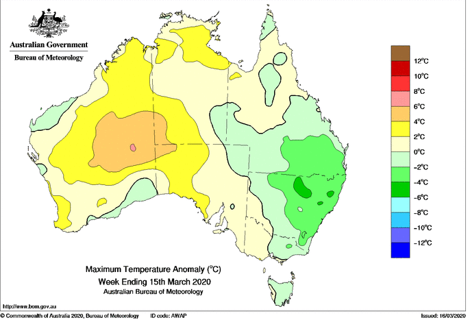
Image 1: Maximum temperature anomaly for the week ending 15th March, 2020
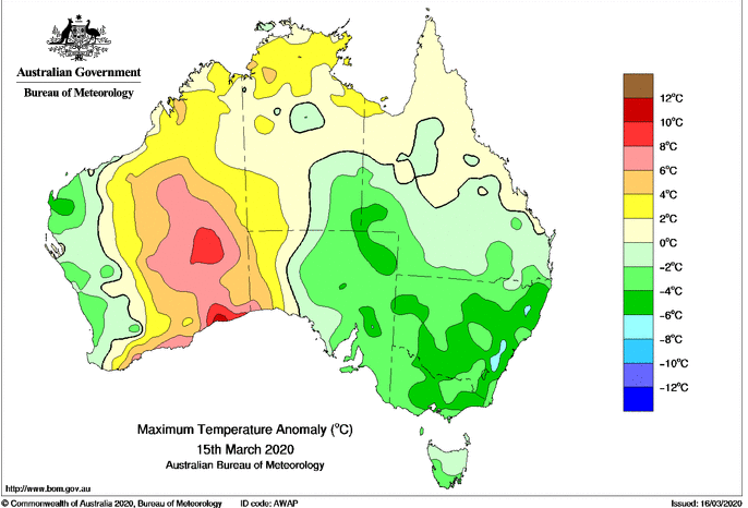
Image 2: Maximum temperature anomaly for the 15th March, 2020
If anyone thinks it flipped from summer to autumn quickly this year, they would not be wrong as many parts of southeastern Australia are experiencing their coldest weather this early in the year for a number of years.
A strong cold front swept over the region on the weekend, bringing an unseasonably cold blast of air, with temperatures more typical of those after the autumn equinox or in April than of mid March.
Sydney struggled to just 17.9 degrees on Saturday, its coldest March day since 1970, although it was just 13.3 degrees around 3pm which was also its official minimum temperature (the lowest minimum this early in the year since 2008). Strong winds associated with the front made it feel below 10 degrees at times, during the peak time of heating, which isn't even a common occurrence in winter in the harbour city.
Chilly conditions were also experienced in Melbourne over the weekend with temperatures more than five degrees below average, although this wasn't unusual for the city. However this morning the mercury dipped to just 9.3 degrees, the coldest its been this early in the year since 2009.
The chill has been felt up into southeast Queensland, with Brisbane currently experiencing its coolest run of March nights since 2008. Humidity levels have also been unusually low for this time of the year and combined with strong southeasterly winds, temperatures have felt 3-4 degrees colder than recorded.
Cool temperatures will be replaced by warmer weather this week as the high in the Tasman moves away. Melbourne will reach the high 20s to low 30s by mid this week, whilst Sydney will push into the low to mid 30s on Friday. Temperatures reaching the 30s are likely in Brisbane by the weekend.
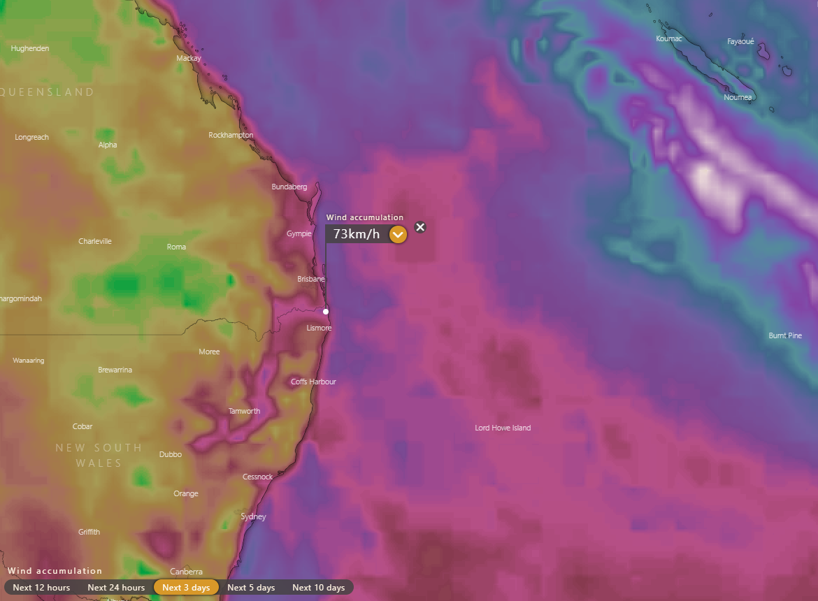
Image 1: EC model forecast maximum wind gust speeds within next three days - Source: Windy.com
A large tropical low in the Coral Sea is forecast to continue strengthening while tracking southeast well out to sea. While the low is currently forecast to reach tropical cyclone intensity early Sunday, there is still some uncertainty about the timing of this and it may occur earlier or later than expected.
Despite the fact the system itself will keep tracking southeast and come nowhere near the Australian mainland, it is still likely to be strong enough (in conjunction with a high pushing a south-southeasterly wind surge up the coast) to cause gusty winds to develop along the southern Queensland and northern NSW coasts on Sunday and Monday. Higher terrain inland of the coast is also likely to experience gusty winds. Peak gusts are likely to reach 60 to 80km/h at times but much weaker gusts are expected for more sheltered areas.
Swells are also likely to increase along the southern Queensland and northern NSW coast later on Monday into Tuesday before easing again.
However only some isolated showers are expected near the coast during this time. The only exception is a possible localised area of moderate to locally heavy rainfall along a small section of the NSW Mid North Coast for a short time early Sunday due to a surface and upper trough.
Meanwhile Norfolk Island is forecast to experience more significant effects from the tropical system with the main peak expected on Monday when damaging winds, moderate to locally heavy rain and dangerous surf are possible.
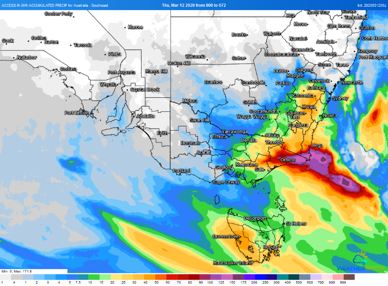
Image 1: Accumulated rainfall across the next 72 hours over southeast Australia (Source: Weatherwatch Metcentre)
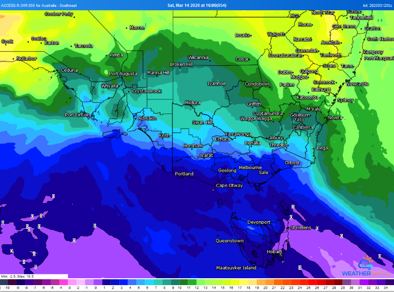
Image 2: 850 temperatures across Southeastern Australia on Saturday 14 March, 2020 (Source: Weatherwatch Metcentre)
After basking in balmy conditions for several days, a cold front is set to sweep across the southeast of the nation, causing temperatures to plummet as well as bringing more good rain across the region.
After a chilly start to March, the last two days have seen temperatures spike up to more than 10 degrees above average across parts of South Australia, Victoria and Tasmania as temperatures reached between the mid 20s and mid 30s.
This heat is set to be short lived though as a cold front sweeps across tomorrow. Areas ahead of the change - including eastern Tasmania, central and eastern Victoria and NSW - will still still see warm conditions on Friday (high 20s to mid 30s) before the front moves through, but as the change hits the mercury will fall more than ten degrees.
By Saturday, Hobart is forecast to reach just 14 degrees (with possible snow over the Tasmanian peaks), Melbourne 19 degrees and Adelaide 22 degrees.
In all states but South Australia (and western Victoria), the front will bring with a burst of moderate to heavy rain as well as the risk of thunderstorms, continuing the fantastic start to 2020. In fact, Melbourne hasn't had such a wet start to a year since 1973 - collecting 256.4mm so far this year and more to come.
Rain, showers and isolated thunderstorms will spread into western Tasmania tonight, before pushing across the remainder of TAS, Victoria and southern New South Wales on Friday and into Saturday morning. By Saturday and into Sunday the rain will predominantly be focused over eastern NSW and eastern Victoria.
How much rain will fall will be highly dependent on the location, with those over central Victoria and southern NSW likely to see falls of 5-15mm, however these totals will increase further east. Over eastern Victoria and southeast NSW, some areas could see in excess of 100mm (especially if a low forms near the coast), whilst the remainder of the VIC ranges and up to the central NSW ranges (including the ACT) will see widespread falls of 15-to-30mm (and some up to 50mm).
Further ahead, coastal rain may linger into next week over central and northern NSW, however there is significant uncertainty about how much rain may fall at this stage.
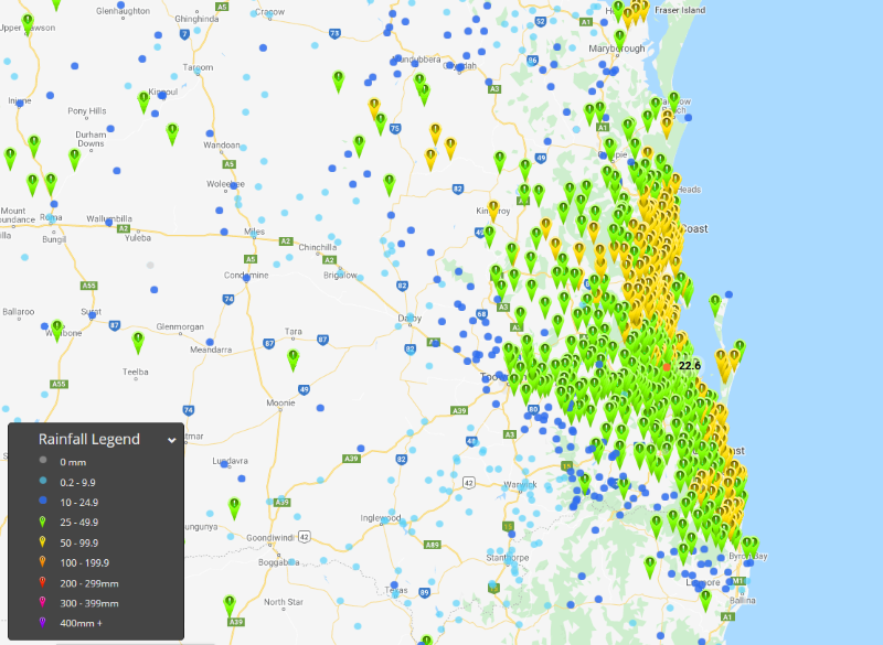
Image 1: 24 hour rainfall totals to 9am 10th March across northern NSW and southern QLD
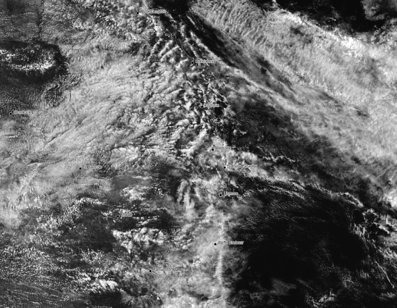
Image 2: Visible satellite image showing the showery conditions in response to the upper low over northern NSW and southern QLD on 10th March
More wet weather drenched southeast Queensland and northeast New South Wales on Monday as a thick band of cloud and rain enveloped the region, which also brought about the coolest March day in decades for some areas.
Gusty and moisture-laden southeasterly winds fed into an approaching upper cold pool to generate the thick cloud and rain band, with widespread steady rain falling throughout Monday and into Tuesday morning. Some coastal areas also received even heavier falls as coastal showers developed within the unstable southeasterly flow.
Over southeast QLD and into northeast NSW (north of about Byron Bay) there were widespread totals of 20-to-50mm, however about coastal areas falls were close to 100mm, particularly about the Sunshine Coast.
The thick cloud and rain also caused some unusually cool temperatures for March. Brisbane CBD only struggled to 21.8C, the coldest March day since 1972. Gatton reached just 21.4C (coldest since 30 years), whilst the Gold Coast also got to 22.7c, the coldest March day since 2003.
Cooler, showery weather is persisting today, although maximum temperatures are reaching into the mid 20s. For the remainder of the week, maximum temperatures will reach the mid to high 20s with a few showers around as southeasterly winds continue in response to a slow-moving high over the Tasman Sea.
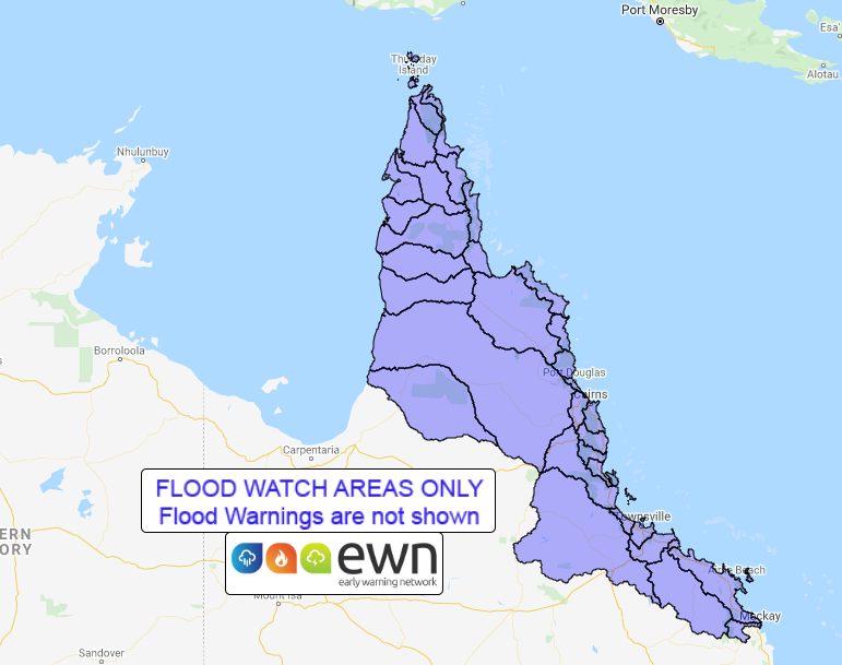
Image 1: Flood watch over northern Queensland issued by the Bureau of Meteorology. Flooding is expected from Wednesday.

Image 2: Tropical Cyclone forecast position on Friday 13th March, 2020 (Source: Windy)
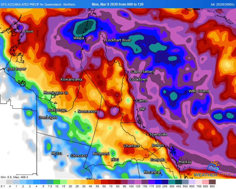
Image 3: Accumulated forecast rainfall for the next five days by the GFS Model (Source: Weatherwatch Metcentre)
Tropical north QLD will face an increasing risk of flooding from Wednesday as a tropical low develops over the northern Coral Sea and possibly develops into a tropical cyclone later this week.
A developing monsoon trough over the north of the state is causing rainfall to gradually increase over the Cape York Peninsula and North Tropical Coast and Tablelands, with local heavy falls expected under thunderstorms today and tomorrow.
Wet weather will become more widespread and spread south into the Central Coast and Whitsundays district from Wednesday as a tropical low possibly develops within the monsoon trough.
This low may intensify further into Thursday and Friday, with the risk of the system developing into a tropical cyclone by Thursday a moderate risk.
The increased development of this low may cause rainfall to increase even further on Thursday, although this is highly dependent on the positioning of the system.
A flood watch is current from the Cape York Peninsula and coastal catchments south to Mackay, due to the risk of riverine and localised flooding from Wednesday. Catchments are already relatively wet from recent rainfall, making them more responsive to heavy rainfall.
Current indications suggest when the cyclone does form, it will move southeast away from the coast and cause rainfall to ease from Friday, but tropical cyclones by nature at unpredictable.
It is difficult at the current time to predict how much and where rainfall will fall, however this should become much clearer over the next couple of days as the tropical low begins to develop.
Image 1: BoM past week rainfall totals QLD
Image 2: BoM past week rainfall totals NSW
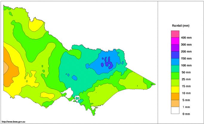
Image 3: BoM past week rainfall totals VIC
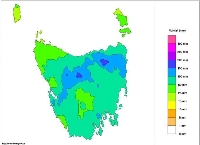
Image 4: BoM past week rainfall totals TAS
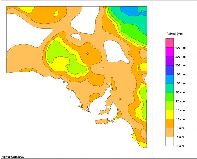
Image 5: BoM past week rainfall totals SA
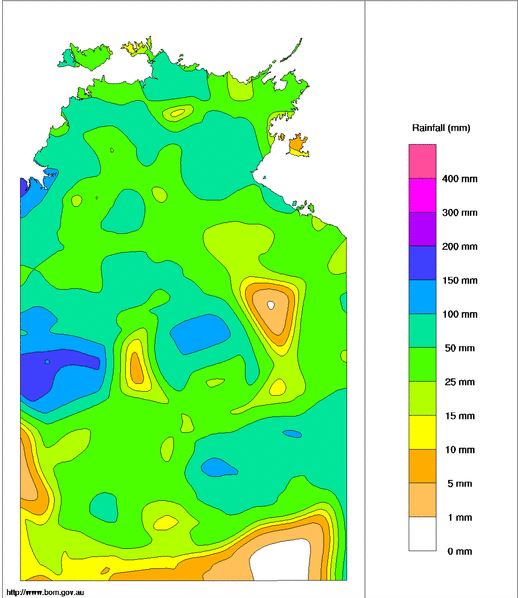
Image 6: BoM past week rainfall totals NT
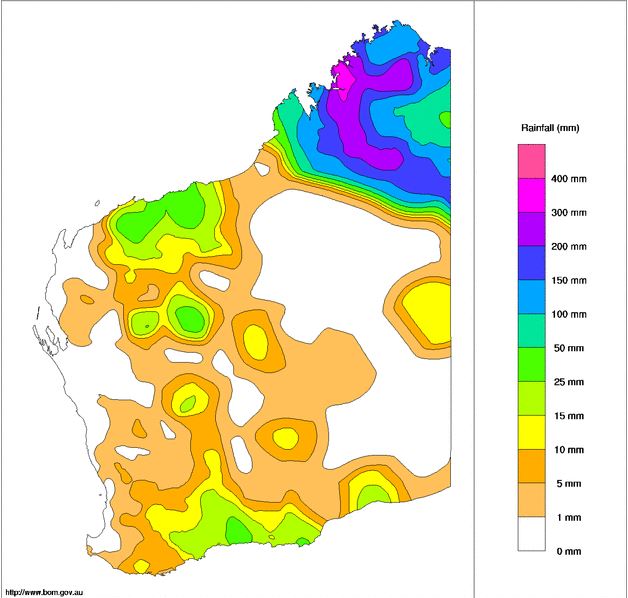
Image 7: BoM past week rainfall totals WA
A large part of Australia had endured a very wet and stormy to start March, with some locations registering their highest rainfall totals in many years.
Ex Tropical Cyclone Esther dumped heavy rain and storms across northern parts of Western Australia, before slowly drifting across parts of the Northern Territory. The remnants of Esther then interacted with an upper trough across central Australia, generating widespread showers, severe storms and heavy rain periods to southern and central parts of the NT, western Queensland, New South Wales, Victoria, Tasmania and north-eastern South Australia.
Widespread falls of 100-200mm developed across large portions of inland Australia, helping rivers and creeks to flow whilst filtering into Australia's largest catchment and the notoriously dry Murray-Darling Basin.
From Monday to 9am Friday, the highest falls in WA were:
From Monday to 9am Friday, the highest falls in the NT were:
As this system slowly moved east, so did the rainfall totals. Birdsville, in QLD?s far south-west picked up 125mm in the space of 48hrs, including 67.2mm on the 4th of March, making it the wettest single day the town has seen March 2011. Thargomindah recorded 128mm overnight of the 4th and the 5th of March, making it the highest daily total in 29 years (200.8mm in total). Meanwhile, an onshore flow across the Central Coast and Whitsunday?s produced locally heavy falls with Mt Vince East scoring 251mm and Koumala 243mm.
Other notable falls in QLD include:
One region crying out for rain after missing the most recent event was western NSW and VIC, and mother nature produced the ultimate gift to desperate farmers, welcome rain! Moderate to locally heavy falls developed, with Fowlers Gap scoring a sensational 144.4mm, including 120.8mm in a 24hr period.
Other notable falls in NSW include:
Lake Burley Griffin, in our nation?s capital, received 78mm, with Canberra AP picked up 73mm, Deakin Pluvio 76mm and Curtin 73mm.
In Victoria, Melbourne Airport's 70mm to 9am 5/3/2020 was its highest daily rainfall total since February 2005, with the Melbourne CBD seeing its highest daily rainfall total since October 2010. However, the heaviest falls were across northern parts of the state with Mount Buffalo receiving 271.1mm this week and Rose R at Matong North 164.6mm.
Other notable falls in VIC this week, include:
This system wasn?t finished yet, with widespread falls of 30-50mm falling across parts of Tasmania, particularly across northern and eastern parts of the state. Gray, on the East Coast recorded the highest total with 183.4mm, Low Head 58mm, Mount Arthur Summit 157mm, Mount Victoria 111.2mm and Fisher River 101mm.
This widespread rain event has led to flash flooding and riverine flooding for many parts of the country, with numerous flood watches and warnings ongoing across parts of WA/QLD/NSW/SA/VIC/TAS. Major flooding continues across southern QLD, whilst progressively making its way south into the Murray-Darling basin over the next several weeks. Shower and storm activity may return to inland QLD early next week, with the potential for a tropical low or cyclone to impact the east coast. Should this happen, another flood event may develop, this time for coastal locations.
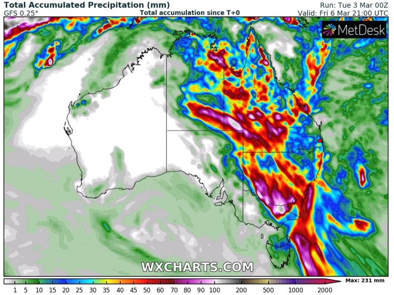
Image 1: GFS Accumulated Rainfall to Friday evening, 00z run Tuesday, 3rd March 2020
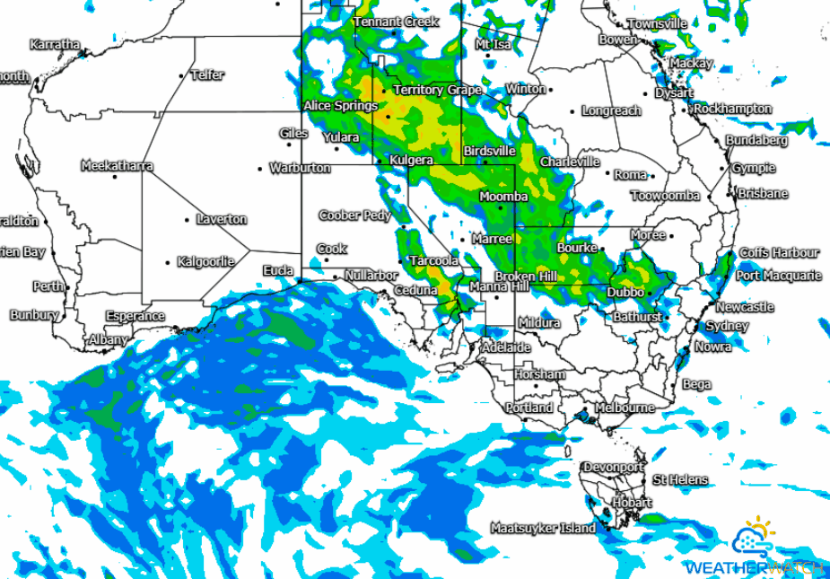
Image 2: MeatherWatch MetCenter GFS Forecast Radar as at 00z run Tuesday, 3rd March 2020
The next few days look set for showers, isolated thunderstorms and heavy rain periods that may lead to flash flooding and riverine flooding to develop across parts of the central and southeastern NT tomorrow with the remnants of ex-TC Esther expected to drift in a southeasterly direction leading into Friday.
The combination of a surface trough, upper low and deep moisture fetch are expected to increase the potential for enhanced rainfall over the next 48-72 hours, with an estimated 25mm-30mm likely with up to 65mm possible for some locations. Some of the heavier rainfall is expected for northwestern parts of NSW from early Thursday before increasing towards the southern parts of the state.
Localised strong to damaging winds are expected to accompany isolated thunderstorm risks, along with heavy rainfall leading to flash flooding. These may bringing renewed river rises due if rainfall does persist over saturated catchment areas.
The good news is a lot of the projected rainfall is forecast to fall through the western interiors of both Queensland and New South Wales, essentially where it's really needed. Late last month saw and active rainfall pattern bringing much relief to western districts of QLD with major flooding particularly through the southern inland parts of the state including Charleville and St. George.
A NSW Flood Watch is current for the Murrumbidgee, Tumut, Queanbeyan and Bulubula Rivers, with Minor Flooding possible. In addition Flood Warnings are in place for river systems in the Upper Western, resulting from previous rainfall. A QLD Flood Watch is also active for western and southern inland QLD catchments due to renewed river level rises and major flooding is possible across parts of the Flood Watch area from tomorrow (Wednesday) onwards.
A number of locations may experience their heaviest rainfall in a few years, with the potential for accumulated rainfall totals of up to and exceeding 125mm over the next 4 days mostly for inland regions. Eastern coastal and adjacent inland districts are expected to see more modest rainfall totals in the order of up to 15mm until the commencement of this coming weekend, before more settled conditions are likely into Saturday and Sunday.
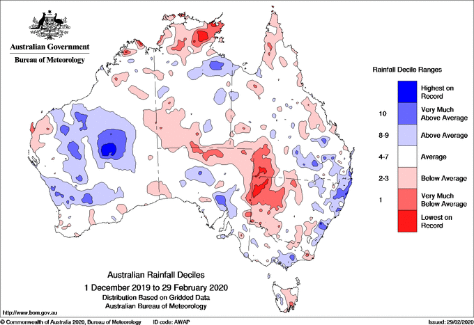
Image 1: Rainfall deciles across Australia for summer 2019-2020
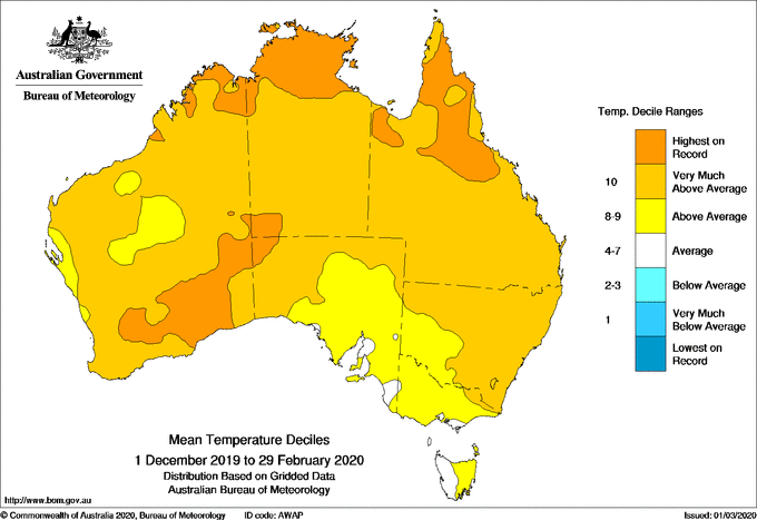
Image 2: Temperature deciles across Australia for summer 2019-2020
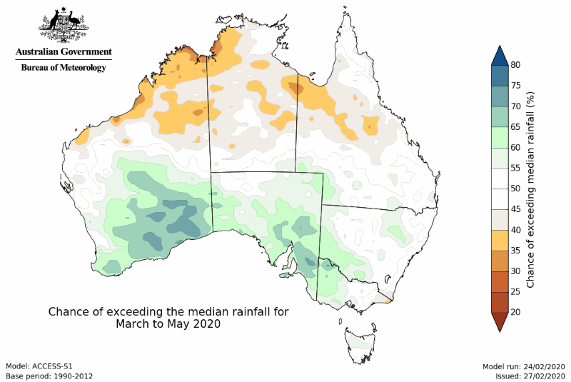
Image 3: Rain outlook from March-May 2020
Summer 2019-2020 was a season of contrasts across Australia, as blistering heat, bushfires and record dry in December gave way to flooding by mid-to-late January and into February as the climate drivers behind the nation's big dry broke down.
In December, the nation was in the middle of a significant bushfire outbreak, as a negative Southern Annular Mode (SAM) and positive Indian Ocean Dipole (IOD) continued to cause prolonged dry conditions. The drought reached its absolute peak in December as the nation recorded its hottest and driest December on record and capped off Australia's driest three year period since national records began in 1900.
Strong winds fueled by the Southern Stratospheric Warming event (that occurred in late winter, but effects dragged into summer) and the negative SAM (which caused increased frontal activity and wind), caused many days to have hazardous fire weather. Combined with the bush being extremely dry and high fuel loads, any fires that started spread very quickly and became highly dangerous.
Fire activity at the beginning of December was generally focused over central and northeastern New South Wales and eastern Queensland, however by the end of the month other large fires had broken out across South Australia, eastern Victoria, the alpine regions, southeastern New South Wales and Tasmania.
These dangerous fire conditions persisted into the first half of January, with close to 19 million hectares of Australian land being burnt by mid January. However, as the IOD and SAM returned to neutral conditions, we saw rainfall return across the country, with rainfall 12% above average nationwide over the month.
The increased moisture lead to a number of severe thunderstorm outbreaks mid-to-late month, including large hail across parts of southwest Sydney, Canberra and southeastern Melbourne. These storms also lead to a number of daily rainfall records falling across NSW and QLD around the 18th. Tropical systems across the north lead to record rainfall in some areas, including a mammoth 562mm in just 24 hours at Dum in Mirrie to the southwest of Darwin on the 11th. This tropical moisture spread south, with parts of Victoria seeing daily rainfall records later in the month, which contributed to some sites seeing their wettest January on record.
Enhanced rainfall continued for parts of the country in February, particularly the southwest of WA and the east. For NSW, rainfall was double the long term average, and close to double the average for the Murray-Darling Basin. A widespread and heavy rain event affected this region early in the month, with a significant number of February daily rainfall records falling across southeastern QLD and into NSW, which lead to flash flooding and riverine flooding. This event contributed significantly to a large number of stations seeing their wettest February on record, while for some places it was their wettest month on record (such as Tweed Heads, with records beginning in 1886).
The increased rainfall and cloudiness also lead to cooler daytime temperatures for the southeast of the country in February, with snow falling over the higher parts of Tasmania.
When crunching all the numbers across the summer, the nation recorded its second hottest summer on record (since nation-wide averages began in 1910), with the mean temperature (maximum and minimum combined) 1.88 degrees above average.
Rainfall was 13% below average, although this was largely due to the extremely dry conditions in December, with rainfall rebounding significantly in January and February.
Looking into autumn, parts of southern Australia are likely to be wetter than average, while some parts of the north are expected to be drier than average. Temperatures should remain warmer than average, particularly at night
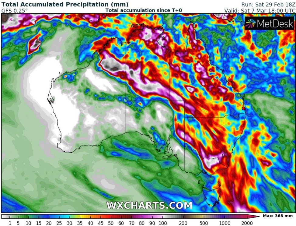
Image 1: GFS Accumulated Precipitation next 7 days. Image via MetDesk/WXCharts
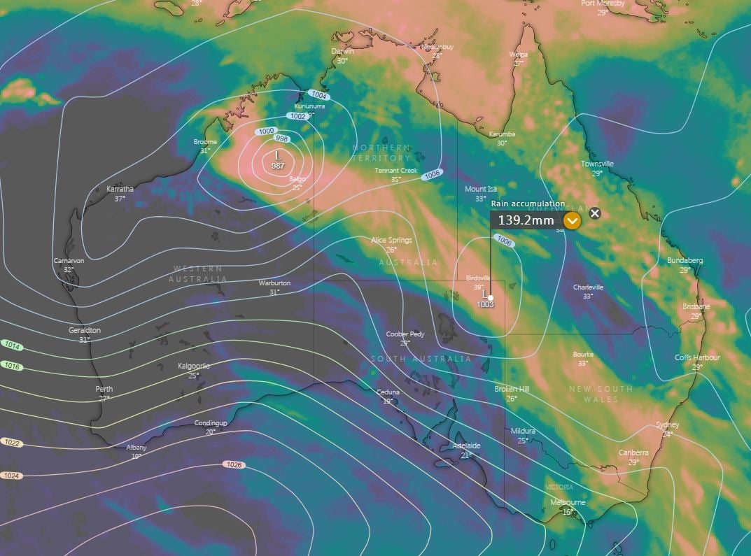 Image 2: EC Accumulated Precipitation next 10 days. Image via Windy.com
Confidence is increasing for showers, storms and heavy rain periods that may lead to flash flooding and riverine flooding developing across the interior of the country this week.
The remnants of ex TC Esther is expected to slowly drift in a south-easterly direction over the coming days, whilst interacting with a surface and upper trough. This is expected to lead to widespread showers, storms and rain periods later this week.
As ex TC Esther moves south-east, it will bring moisture laden air to the interior of the country, with heavy rain periods and thunderstorms, a few of which may be severe and contain damaging winds and pose a flash flooding risk.
Southern parts of the Northern Territory and northern South Australia are likely to feel the effects of this system during the next 48 hours (widespread storms are already affecting north-western SA) before slowly spreading into western Queensland, New South Wales and Victoria.
Some locations may see their heaviest falls in years, with the potential for accumulated rainfall totals of up to and exceeding 150mm over the next 5-9 days.
Stay tuned for further details throughout the week.
A large part of Australia had endured a very wet and stormy to start March, with some locations...
It was the most hotly-discussed weather content on the internet for the better part of a week, and...
Tropical Cyclone Jasper barrelled across the western Coral Sea late last week, through the weekend...