Weather News Archive 2019 June
Image: ACCESS-R accumulated forecast rainfall
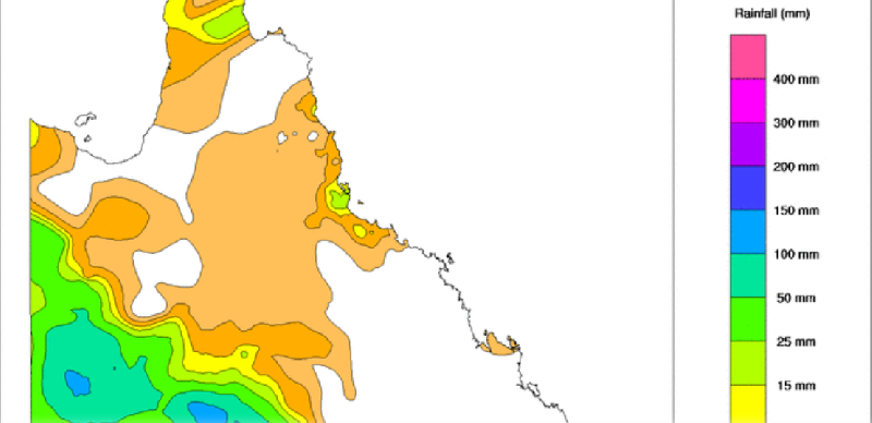
Image 1: BoM PME Rainfall Map QLD
The remnants of Ex-Tropical Cyclone Trevor are drifting across Queensland, and are expected to generate widespread heavy rainfall across parts of the state over the next several days, especially the parched interior.
Heavy rainfall has already drenched the state's far west, with some areas receiving the best rain in years. Notable falls in the 24 hours to 9am today included 135mm in Urandangi, 135mm at Stonehenge and 176mm at Roxborough Downs, prompting minor flood warnings across the region.
Heavy rainfall and associated thunderstorms are expected to continue across Queensland over the next several days, with the focus of the heaviest falls over the west of the state today, before gradually spreading east.
Central areas of the state are likely to receive the best falls, with widespread totals of 50-150mm likely stretching from Boulia in the west to Rockhampton in the east, with some areas possibly receiving in excess of 300mm over a few days.
Some of this rain will also spread into southeast Queensland, where many parts will see falls of 50-to-100mm, although areas of the Sunshine Coast could see totals of 150-to-250mm.
This rain is great news as it will be reaching some areas that received little if any rain during the north Queensland floods. Likewise, thick cloud will put a significant lid on record March heat that has been affecting the state, with some areas currently receiving a hotter March than they did January.
The final day of significant rain and thunderstorms will be Saturday, before a strong cold front causes clearing of most areas except northeast Queensland by Sunday.
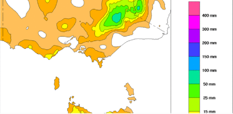
Image 1: BoM PME Rainfall Map VIC
Cold, windy and wet conditions across Australia's south are contrasting record March heat across eastern Australia as an intense cold front affects the region.
The vigorous cold front, that is associated with a deep low over the Southern Ocean, brought damaging wind gusts to Victoria and Tasmania last night, leading to power outages across the states.
While the highest gusts were typically recorded in more exposed areas, some notable wind gusts included: * 131km/h at Maatsuyker Island (TAS) * 124km/h at Wilsons Promontory (VIC) * 122km/h at Scotts Peak (TAS) * 117km/h at Mount Wellington (TAS) * 115km/h at Mount Hotham (VIC) * 95km/h at Devonport (TAS)
Thunderstorms and showers also accompanied the change, with parts of western Tasmania and northeast Victoria receiving moderate falls. Whilst a very isolated fall, Mount Hotham (upper site) recorded 116mm in the 24 hours to 9am today, its heaviest March total on record.
Winds are remaining strong across exposed parts of Victoria and through much of Tasmania today, with a Severe Weather Warning for 90-100km/h gusts in effect for today in these areas.
Meanwhile, ahead of the change and trough, unseasonably hot March weather is affecting parts of eastern Australia, with records falling in areas. Yesterday, Grafton reached 39.4 degrees, a record for March (in more than 100 years of records), and is predicted to hit 38 degrees again today.
Brisbane is on track for its third consecutive day in the mid 30s, and is comfortably on track to record its hottest March on record, along with many other parts of eastern Australia.
Thankfully, cooler and wetter conditions are expected for much of this week in many areas.
More settled conditions are expected across Victoria and Tasmania from tomorrow, before another front arrives late Friday or Saturday.
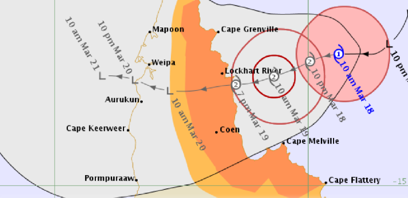
Image 1: BoM TC Trevor Track Map
Tropical Cyclone Trevor was officially named in the early hours of this morning, and is expected to intensify before making landfall later tomorrow, bringing the risk of destructive winds and flooding to the Cape York Peninsula.
Trevor, currently a Category one system, was located 340 kilometres north of Cooktown at 10 am AEST and was moving west-southwest.
The system will continue to move in a similar direction and intensity gradually, likely reaching category 2 intensity by later tonight or early tomorrow morning, before making landfall late tomorrow.
A Cyclone Warning is current between Orford Ness and Cape Flattery, including Coen and Lockhart River, with a Cyclone Watch extending to Cape York and Cape Tribulation, including Cooktown.
In Trevor's path, heavy rainfall with falls in excess of 300mm are likely, bringing the risk of flooding, while destructive wind gusts in excess of 125km/h are possible near the centre.
Meanwhile, ahead of the change and trough, unseasonably hot March weather is affecting parts of eastern Australia, with records falling in areas. Yesterday, Grafton reached 39.4 degrees, a record for March (in more than 100 years of records), and is predicted to hit 38 degrees again today.
Abnormally high tides are also possible, with the risk of indundation of low-lying areas as the cyclone crosses tomorrow.
After crossing Cape York Peninsula, Trevor is likely to move into the Gulf of Carpentaria again and reintensify. While it is difficult to predict a cyclone's path several days in advance, current indications are it may make landfall again over the Northern Territory later this week.
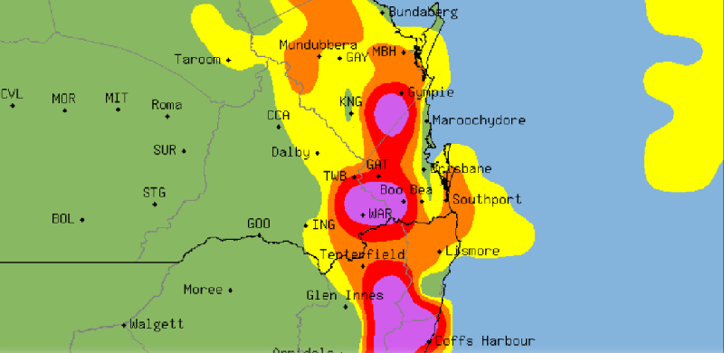
Image 1: Severe Thunderstorm Probability Chart - SE/QLD & NE/NSW
Record March heat is giving way to potentially severe thunderstorms over southeast Queensland and northeast NSW over the next few days as a southeasterly change pumps moisture into a low pressure trough lying over the region.
Temperatures have skyrocketed the last few days as an unseasonably hot airmass lies over the region, and westerly winds pushing much closer to the coast than usual for this time of the year. Gatton has eclipsed 40 degrees three days in a row (breaking its previous March record on three consecutive days), including reaching 41.1 degrees on Tuesday.
Amberley also saw a new March record on Tuesday, reaching 41.3 degrees, while Brisbane has reached the mid 30s on three consecutive days, including 37.7 degrees on Tuesday, making it the hottest March day since 2007. Casino hit 39.6 degrees on the same day, also a March record.
Thankfully the heat will break up over the next few days, as cloudiness increases over the region and the risk of rain and thunderstorms become progressively higher.
With the increased moisture from the southeasterly change today, severe thunderstorms are expected to fire up across the region tomorrow, particularly over the ranges where thunderstorms may become severe, bringing the risk of damaging winds, large hail and heavy rainfall. Most coastal areas are likely to miss out.
Thunderstorms will become more widespread on Friday as instability increases further, with coastal areas also likely to be affected. Thunderstorms will bring the risk of frequent cloud-to-ground lightning, as well as heavy rainfall, damaging winds and large hail.
Over the weekend, thunderstorms and rain areas have potential to bring the best rain in months to the region, with potential for 24 hours in excess of 100mm in some places, although thee remains uncertainty with where the heaviest falls will be at this stage.
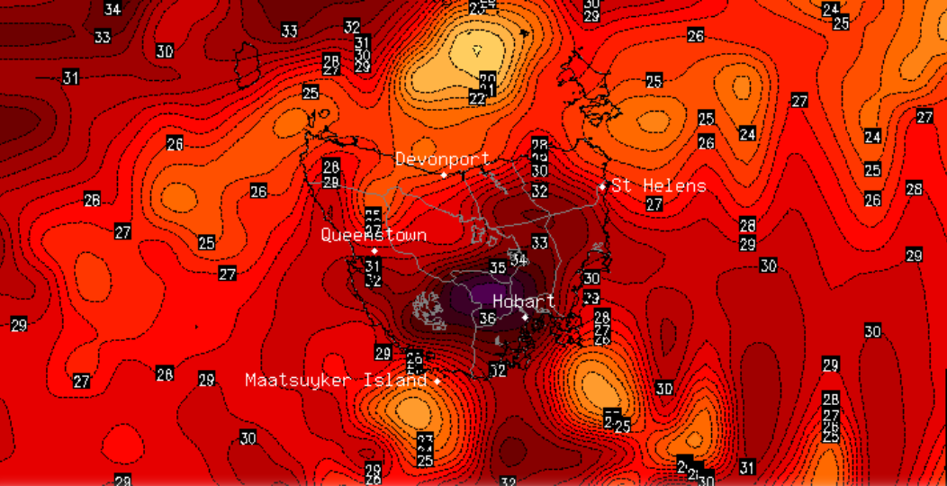
Image 1: Maximum daily temperature chart - State of Tasmania
Record challenging March temperatures and bushfire conditions equal to the worst they have been this season are set to hit Tasmania tomorrow as a low pressure trough sweeps across the state.
Hot, dry and gusty northerly winds will send temperatures into the high 30s across parts of the state. Hobart is predicted to reach 37 degrees with a chance of it being even hotter, putting the current record of 37.3 degrees under threat.
Fire Danger is expected to reach Severe across the Midlands, Upper Derwent Valley and South East, which is likely to exacerbate previously fires and possibly re-threaten communities that have already been hit hard by bushfires this summer.
A cooler change is likely across the state on Sunday, which may be accompanied by some light patchy rain in parts, however warmer than average conditions are likely to persist until a more substantial cold front arrives on Wednesday.
Image: ACCESS-R accumulated forecast rainfall
Image 1: PME Total Rainfall forecast
Numerous hailstorms hit parts of northeast New...