Weather News Archive 2019 September
Image 1, Current EWN Radar w/lightning overlay (12.45pm)
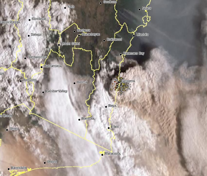
Image 1: NSW fire storm across the South Coast. 31/12/2019
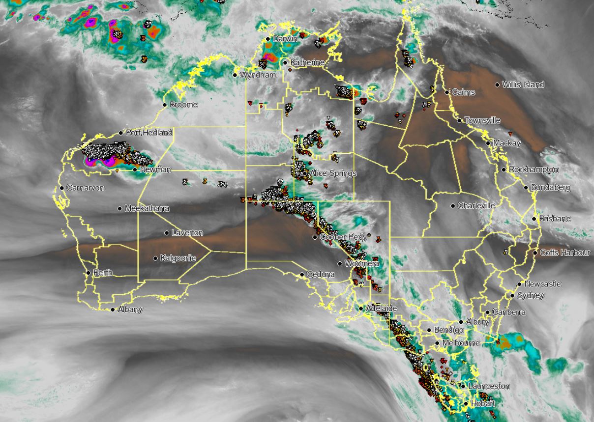
Image 2: Australian water vapour satellite image. 30/12/2019
South Eastern parts of the continent have sweltered under another intense heatwave, with temperatures skyrocketing into the low to mid 40's for numerous regions once again.
A pre-frontal trough and cold front advanced across southern parts of Australia, and in combination with a high pressure system in the Tasman Sea, dragged a very hot airmass from north-western Australia into the southern states. These systems in combination, produced a strong pressure gradient which lead to severe weather warnings and damaging winds for NSW, VIC and SA.
Temperatures soared across parts of TAS with Hobart recording its hottest December day on record, reaching 40.8°C, eclipsing the previous record of 40.6°C set back in 1897. This also made it Hobart?s second hottest day in history. Other notable temperatures in TAS were Friendly Beach 42°, Swansea 41° and Ouse 40°C.
Along the frontal system, a tongue of mid-level moisture would help in the development of thunderstorm activity, which stretched from southern parts of the NT, through SA, NSW, VIC and into TAS. The resultant thunderstorm activity also halted the Big Bash game in Launceston between the Hobart Hurricanes and the Melbourne Stars. Due to the very dry conditions at the surface and high based thunderstorms, these quickly became severe with damaging winds in the form of microbursts.
The strongest gusts recorded in associated with thunderstorm were, VIC: Melbourne Airport 91km/h, St Kilda 93km/h, Kilmore 93km/h, Walpeup 104km/h and Hopetoun 96km/h. SA: Renmark 93km/h, Cultanta 95km/h. TAS: Hobart 87km/h and Mount Wellington with a 104km/h wind gust.
The very hot conditions and strong winds fanned dangerous bushfires across SA, VIC, NSW and TAS with numerous emergency warned fires developing for these locations. Some of these fires are so big and intense they were warned by the Bureau of Meteorology for destructive winds and also produced numerous lightning strikes across the East Gippsland in VIC and South Coast of NSW (pyro-cumulus). The tops of these fires or pyrocumulus clouds were nearing 16km high effectively creating their own weather systems.
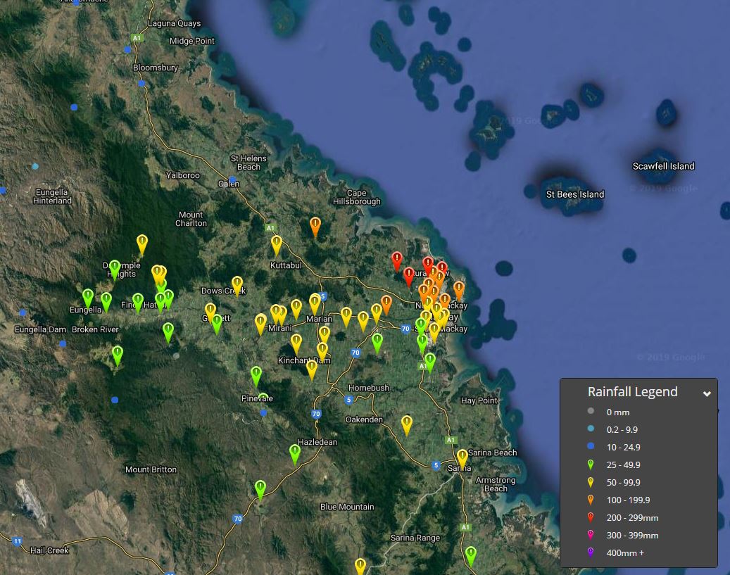
Image 1: Rainfall totals, 24hrs to 9am 28/12/2019
Heavy rainfall has lead to flash flooding across parts of Mackay overnight.
A slow-moving storm complex in association with a moist onshore flow, produced totals in excess of 100mm for numerous locations, with isolated falls exceeding 200mm. These heavy falls have lead to flash flooding, particularly in the Beaconsfield region of Mackay.
Heaviest falls to 9am this morning were, McKillop with 228mm, McCreadys Creek 228mm, Rowallan Park 209mm and Black Mountain 205mm. Other notable falls were Mackay with 118mm (highest daily December total since 24th 2012), Mount Pleasant 164mm, Dumbleton Rocks 105mm, Golflinks 178mm
During Saturday, further showers and thunderstorms are expected, with isolated heavy falls possible throughout the day.
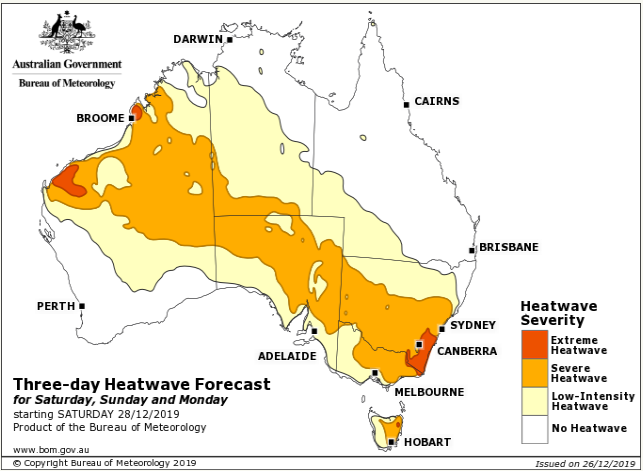
Image 1: BoM Heatwave forecast for Saturday, Sunday and Monday
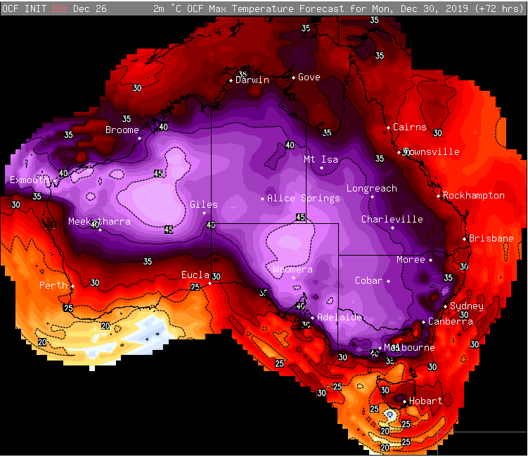
Image 2: OCF Forecast Temperatures for Monday 30th December, 2019
Another wave of heat is spreading across Australia's southeast over the next several days, and while temperatures aren't expected to reach the heights of last week, there are likely to be some dangerous fire days once again as winds increase.
People in the southeast have had a reprieve of heat due to a cold front, after temperatures reached up to 49.9 degrees last week, however the hot airmass has only just retreated back to the north and interior. Darwin sweltered through its hottest night on record last night, dipping to only 30.2 degrees, while Coober Pedy has been reaching the low to mid 40s every day since Sunday.
A trough will drag this heat south once again, with most inland locations over South Australia, Victoria, New South Wales and Queensland likely to reach the mid-to-high 30s to low 40s, with areas in the interior hitting the mid 40s.
Adelaide will see four consecutive days reaching the high 30s or low 40s between today and Monday, whilst western Sydney will see temperatures become increasingly hotter from tomorrow, reaching 40 degrees in Penrith on Saturday, and up to 45 degrees by Tuesday.
The heat will spread further south this time into Tasmania, with Hobart reaching 31 degrees tomorrow and 37 degrees on Monday. Melbourne is expected to reach the low-to-mid 40s on Monday.
Whilst not too many records will be threatened by this wave of heat, the main concern is the fire risk due to associated windy weather.
Windy conditions are likely over parts of SA, NSW, VIC and TAS tomorrow and may be associated with dry lightning, which brings a significant risk of new blazes, although at this stage it isn't expected to be as bad as last Friday across SA.
However, the day of concern is on Monday across SA, VIC, TAS and southern NSW, where there is potential for fire danger to reach extreme to catastrophic as winds gust to 80km/h with possible dry lightning - conditions very similar to last Friday.
The fire risk will shift to NSW on New Years Eve as temperatures soar into the 40s, before a southerly buster with gusts to 70-80km/h pushes up the coast, causing difficult conditions for fire fighters once again.
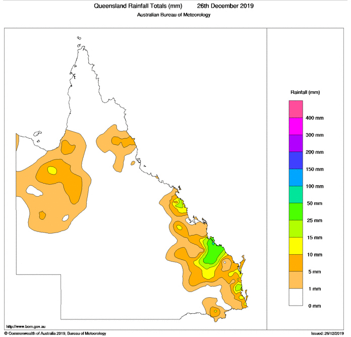
Image 1: Rain totals in the 24 hours to 9am today (Source: Bureau of Meteorology)
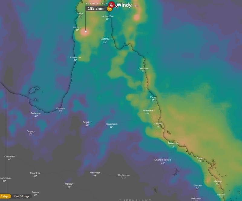
Image 2: Accumulated rainfall totals for the next 5 days for central and northern QLD (Source: Windy.com)
Showers and thunderstorms on Christmas Day and Boxing Day have been bringing much needed rain to the QLD coast, with some places seeing their best rain in more than two years.
A low pressure trough that is being fed by humid onshore winds has brought scattered showers and storms along the QLD coast (except between about Proserpine to Ingham, which has missed out).
Those in southeastern, central and far northern areas have received the best falls so far from the system. On Christmas Day, a healthy cluster of thunderstorms which was also associated with a spectacular lightning display formed over the state's central east, bringing substantial totals from Gladstone to the Town of 1770, inland to Coonambula.
Gladstone recorded 62mm in the 24 hours to 9am its best rain since October 2017 and heaviest for December since 2010. A lot of this rain came down quickly, with 23.8mm falling in just 10 minutes around 7pm EST.
Healthy totals also occurred around the Sunshine Coast and the Mackay area, with 40mm falling at Caboolture, 48mm at Boreen Point and 41mm at Walkerston (just inland from Mackay).
Today, the heaviest falls have been focused over the tropical north coast, with thunderstorms developing this morning and continuing into this afternoon, bringing locally heavy falls. In the Gordonvale area, small hail was even reported from thunderstorms this morning, not a common occurrence at sea level in the tropics.
Over the next few days, showers and isolated thunderstorms will continue for coastal Queensland, particularly north of about St Lawrence. Many areas should pick up further totals of 30-to-50mm, with some locations likely to see a further 50-100mm by the end of the weekend (possibly 100-to-200mm over the Cape York Peninsula).
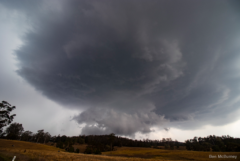
Image 1: Supercell characteristics associated with Christmas Eve supercell thunderstorms as provided and observed by EWN Alerts Operator and Forecaster Ben McBurney SE of Urbenville, NSW.
A cluster of isolated thunderstorms developed around the Armidale, Guyra and Dorrigo areas around 1:00pm and began to consolidate while drifting slowly to the northeast. At 2:50pm, the Bureau of Meteorology NSW issued a Severe Thunderstorm Warning for Large Hail and Heavy Rainfall for people situated within parts of the Mid North Coast and Northern Tablelands with activity detected near Kempsey, Dorrigo and Ebor.
By 3:00pm, two separate thunderstorms were active with the region with one complex location to the east of Glen Innes with the other situated on the ranges to the west of Coffs Harbour, NSW. Over the course of the next two hours, the severe thunderstorm to the east of Glen Innes intensified further into a significant thunderstorm and made it's way northeast through Jackadgery and up to the eastern parts of Tabulam. At 4:19pm, the Bureau of Meteorology updated their warning and included damaging winds with another warning following for parts of Lismore, Grafton, Tenterfield, Casino, Kyogle and Maclean by 5:32pm.
This thunderstorm in particular was very long tracked in nature and continued on to meet up with the QLD/NSW border by 6:30pm. At 6:30pm, severe thunderstorms were detected on the Border Ranges and were delivering most noteworthy of all, very heavy rainfall rates. At 6:32pm, the Bureau of Meteorology QLD issued a Severe Thunderstorm Warning for people in parts of the Scenic Rim and Gold Coast areas for heavy rainfall.
Image 2: EWN Lightning Tracker detailing extensive and very lightning thunderstorms detected south of Bonalbo and west of Casino, NSW on December 24th, 2019
Over the course of the next hour to 7:00pm, the line of thunderstorms intensified further while moving to the northeast towards the Brisbane CBD, with a continuation of extremely high lightning rates. Many of these lightning strikes resulted in 1,200 people in the Logan City Council region to lose power with a further 1,100 within the Moreton Bay region. The power outages also had an effect on public transport with Queensland Rail suspending train services on the southside line between Kuraby and Beenleigh. Fallen powerlines were also reported just after 7:30pm at Archerfield as well as 40mm of rainfall recorded at Beechmont.
At 8:00pm the line of thunderstorms had just passed through the Brisbane CBD and was located over both the bayside and the inner northern suburbs of Brisbane, including the Brisbane Airport. At 8:04pm, the warning area had two specific thunderstorms in progress with the western cell located at Boonah and forecast to affect Laidley, and parts of Esk with the primary thunderstorm forecast to affect Strathpine, Redcliffe and Caboolture by 8:30pm with damaging winds and heavy rainfall with primary threats. At 9:30pm, the line of thunderstorms reach northern areas of the Sunshine Coast about Caloundra and Maroochydore whilst weakening and moving to the north-northeast offshore.
This significant thunderstorm was very long track over a long period of time, essentially covering a total distance of approximately 465kms from the northeast of Armidale, NSW to Maroochydore, QLD. Armidale is still very short of it's annual December average of 96.7mm.
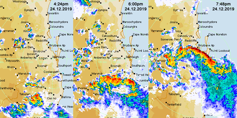
Image 3: Severe Thunderstorm Progression from the Northern Tablelands of NSW to Brisbane City, QLD on the 24th of December, 2019
The most noteworthy element for this particular Christmas Eve event was rainfall received for locations that have been dry for some time, with the Benobble, QLD alert receiving 66mm of rainfall (24 hours to 9:00am, 25th December, 2019) with a very welcome 61mm over the Busby Flat fireground with 57mm recorded for Byron Bay, NSW.
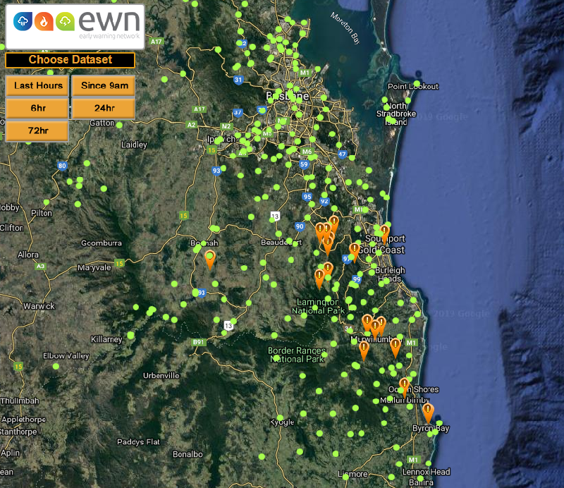
Image 4: 24 hour Rainfall totals between 9:00am 24th December, 2019 to 9:00am on the 25th, December 2019. AMBER arrows are indicative of rainfall above 50mm via the EWN Rainfall Map.
From all of the team here at the Early Warning Network, we would like to wish you a very safe and Merry Christmas and remember to keep alert and aware of all severe weather and/or potential threats over the holiday period.
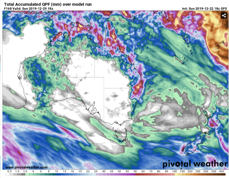
Image 1: GFS Accumulated rainfall across the next 7 days over Australia (Source: Pivotal Weather)
Image 2: ECMWF Accumulated rainfall across the next 10 days over Australia
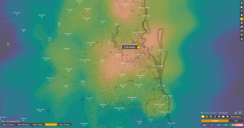
Image 3: ECMWF Accumulated rainfall across the next 5 days over southeast QLD
Good news is ahead for parts of eastern and northern Australia to cap off 2019, with some places likely to see some of their best rain all year in what has been an extremely dry and warm year for the nation.
Two climate drivers - the Indian Ocean Dipole and the Southern Annular mode have been combining over the last several months to bring prolonged dry conditions to the country. The Indian Ocean has been in a positive phase, whereby all the warm water (and wetter conditions) lies in the western Indian towards Africa, with the cooler waters (and drier conditions) in the eastern Indian near Australia.
Meanwhile the Southern Annular Mode has been in a negative phase, which has caused increases in frontal activity. This hasn't been bad news for parts of southern Victoria and Tasmania, however it has driven very dry conditions across much of the rest of the country, with strong frontal systems pushing out any moisture that has built up across the country, preventing widespread rain events.
Thankfully, both these climate drivers are breaking down and returning closer to neutral, finally allowing moisture to build over the country, with some good rain on the way for the northern tropics, eastern Queensland and parts of New South Wales (mainly the northeast).
In the wake of a strong southerly change that swept up the coast over the weekend, easterly winds have been pushing well inland, allowing moisture to feed into troughs of low pressure over the east of the country.
A few thunderstorms developed over the northern inland of NSW and southern inland of QLD yesterday, however more widespread activity is likely today as moisture increases.
This moisture is likely to increase further on Christmas Eve and Christmas Day over northeast NSW and southeast QLD, with potential for heavy falls in some areas. Many parts stretching from the NSW Mid North Coast to the QLD Wide Bay and Burnett and to the eastern Darling Downs have potential to see widespread falls of 25-to-50mm, with some places, particularly closer to the coast, likely to see falls of 50-to-100mm, with isolated falls in excess of this under thunderstorms (which bring the risk of flash flooding). Some areas in central and southern coastal NSW will also see rain, although totals will be much lower.
Whilst the heaviest rain will clear these areas by Boxing Day, easterly winds from the Coral Sea will push well inland and north, causing increased instability over the northern tropics. Moderate-to-heavy falls are likely to spread into large parts of the remaining QLD coast and inland, with some parts of northern inland QLD (i.e. Mount Isa), a chance of seeing their best rain since February.
Whilst confidence is lower, there is a good agreement that the remainder of the northern tropics (including Darwin) will see moderate to heavy falls develop closer to New Years. This will bring substantial relief to the northern tropics that have been sweltering in record December heat, with just 45mm recorded at Darwin so far this December (average 254mm).
The increase of moisture over the northern tropics also bodes well into the start of 2020, with the chance of this moisture getting collected by low pressure troughs over the west of the country and bringing rain to Western Australia and central Australia, although this is too far away in the future to predict at this stage.
At the very least, the increase in cloudiness should take the edge off the heat for a while.
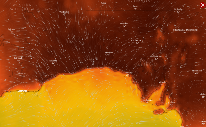
Image 1: Windyty surface winds from the north with temperatures soaring over 47 degrees yesterday, Thursday, 19th December 2019 via the Bureau of Meteorology.
The current weather pattern situated over southern Australia will see the continuation of a very hot air mass dominate over southeastern WA and southern parts of SA before a significant frontal system sweeps across the western and southern regions of South Australia tomorrow, with winds easing slightly proceeding the frontal boundary with a moderate southerly windflow. The front will likely then move over the northeast parts of South Australia during the weekend with another high pressure system expected to anchor in the southern parts of the Great Australia Bight.
Multiple heat records have been broken today, with parts of Western Australia and South Australia enduring their hottest conditions in recorded history. A noteworthy record was for Eucla, WA where the temperature maxed out at a sizzling 49.8° at 12:24pm, beating the previous December record of 49.3° set on the 17th of December, 1912 - 107 years. Western Australia did briefly snatch the Australian December maximum temperature record off Queensland with the Eucla maximum temperature today (49.8°), however this was only held for less than 2 hours before Nullarbor in South Australia took the record off Western Australia.
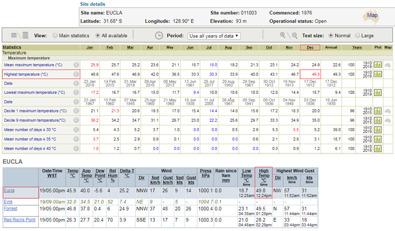
Image 2: Eucla, Western Australia AWS Station all-time record data and observations recorded, Thursday, 19th December 2019 via the Bureau of Meteorology.
Nullarbor, SA reached a blistering 49.9° at 4:54pm this afternoon making this observation the 4th highest temperature on record in Australia. Nullarbor beat the previous all-time maximum temperature by +1.4° set back on the 2nd of January, 1990 - 29 Years. Ceduna, SA reached a maximum temperature of 48.9° at 4:26pm this afternoon beating the previous December record of 47.3° set back on the 30th of December, 1976 - 43 years. The new maximum temperature of 48.9° exceeds the all-time record for this particular station of 48.6° set on the 24th of January earlier this year.
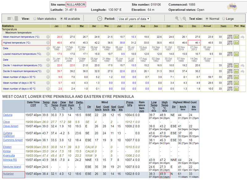
Image 3: Nullarbor, South Australia AWS Station all-time record data and observations recorded, Thursday, 19th December 2019 via the Bureau of Meteorology.
Adelaide's temperatures soared with West Terrace peaking at 45.3° with 45.2° recorded at Kent Town. The overnight ambient temperature is only expected to drop to balmy 32° overnight. The South Australian Ambulance Service has so far attended 239 heat-related incidents, with 145 patients requiring transport to hospital.
Unfortunately, tomorrow looks primed for a very dangerous day with the combination of extremely hot daytime conditions and strong to gusty winds associated with the frontal system. This has in turn elevated the fire danger to CATASTROPHIC levels for people situated within the Lower Eyre Peninsula, Mid North, Mount Lofty Ranges, Yorke Peninsula, Kangaroo Island parts of the state tomorrow ,with the Lower South East within the extreme fire danger zone. Severe fire dangers are expected to be present though the balance of the state including both the North East and North West Pastoral districts, West Coast, Adelaide Metropolitan, Riverland, Murraylands and Upper South East districts.
Catastrophic fire conditions are the WORST fire conditions for the initiation of a bushfire or a grassfire. If fire takes hold under these conditions, it will be extremely difficult to control and will take significant fire fighting resources and cooler conditions to bring the bushfire under control. Spot fires are expected well ahead of main fire fronts, which traditionally cause the rapid spread of fire with embers coming from multiple directions.
We strongly encourage anyone with friends or family within the danger areas tomorrow to stay alert and aware, and follow all bushfire and weather warnings issued by the relevant fire authorities including the Bureau of Meteorology and via the Early Warning Network. Please also keep a special eye over the elderly, and make sure to look after your pets and animals during such extreme weather conditions.
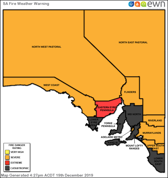
Image 4: Catastrophic, Extreme and Severe Fire Weather Warning areas for Friday for the entire of SA, 20th December 2019 via the Early Warning Network and Bureau of Meteorology.
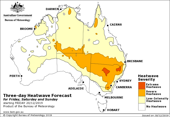
Image 1: Heatwave severity outlook for the next three days
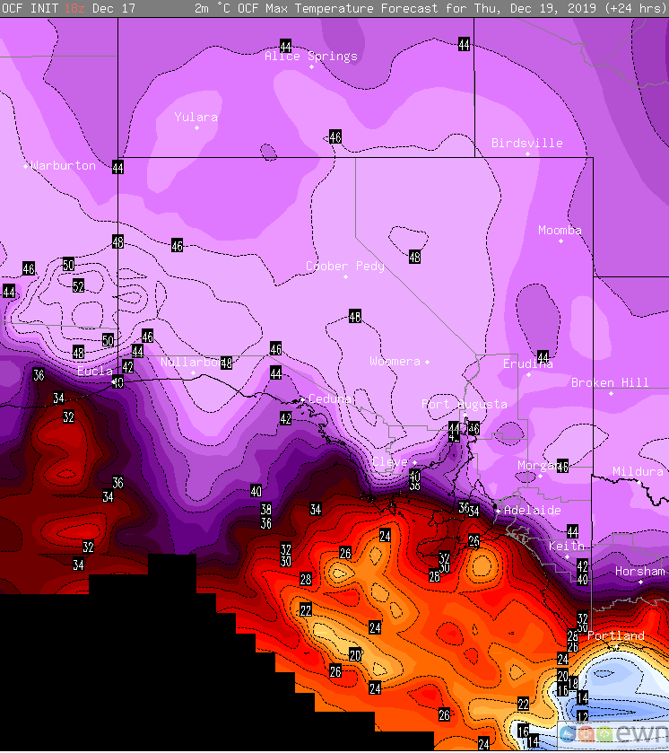
Image 2: OCF Maximum temperature forecast for Thursday 19 December, 2019
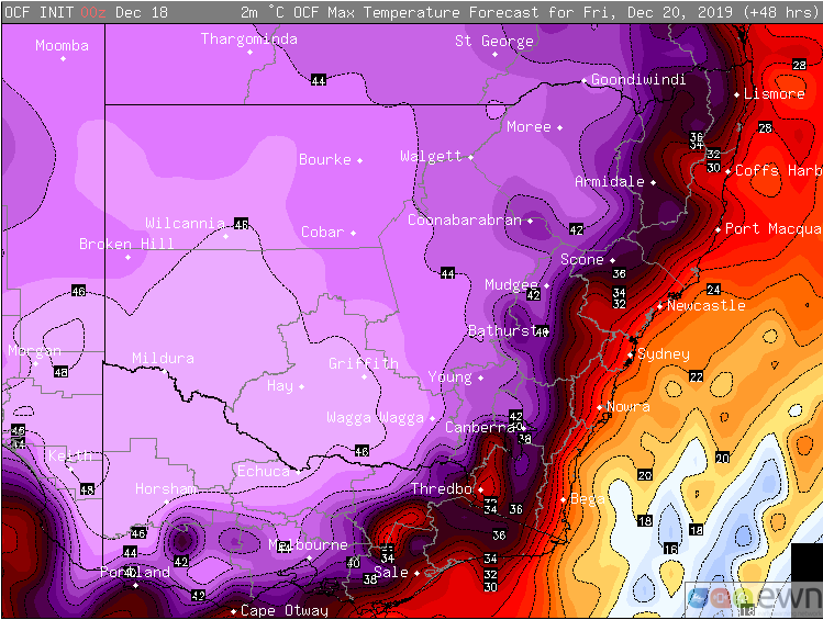
Image 3: OCF Maximum temperature forecast for Friday 20 December, 2019
Temperatures are soaring into the mid to high 40s across southeastern Australia as a extreme heatwave grips the region, with a risk of the mercury reaching 50 degrees in far southeastern parts of Western Australia and far western South Australia tomorrow.
A delayed monsoon and prolonged drought conditions have helped an intensely hot airmass build over the country - more typical of January or February, which broke records over the Northern Territory and Western Australia (including Perth) last week.
According to the Bureau of Meteorology, yesterday officially came in as Australia's hottest day on record (since 1910), with an average nation-wide maximum of 40.9 degrees, breaking the 40.3 degrees set in early January 2013.
The heatwave is now affecting South Australia, eastern WA, Victoria and New South Wales, with the hottest three days yet likely to occur on Thursday, Friday and Saturday, with the nation-wide average of 40.9 degrees likely to be eclipsed again, if not more than once.
Tomorrow, OCF Model output suggests temperatures could reach 50-52 degrees over far southeastern WA and far western SA, although there is a lack of weather stations in this area limiting the amount of data. The nearest station is Forrest, which is forecasted to reach 48-49 degrees.
Adelaide will reach the low to mid 40s over the next three days (after exceeding 40 degrees yesterday), with the December record coming under threat on Friday as the hottest part of the airmass lies over the city. However, just north of Adelaide at Roseworthy, is forecast to reach 48-49c, which would make it comfortably its hottest day on record for any month (since 1909).
Melbourne is set to reach 39 degrees today, and 41 degrees on Friday, with southerly changes bringing brief respite this evening and a more prolonged despite on Friday evening. Meanwhile, Sydney will reach 39 degrees on Thursday and 35 degrees on Saturday, although western suburbs on Saturday are likely to reach at least 46-48 degrees, setting new records.
Inland parts of SA, VIC and NSW are all likely to soar into the low-to-mid 40s over multiple days, with some places reaching the high 40s.
Both Thursday and Saturday are likely to bring potentially devastating bushfire conditions to eastern NSW, particularly over central and southern areas.
Those unburnt areas of the Blue Mountains, Hunter and Central Coast, as well as the Southern Tablelands, South Coast, Snowy Mountains and East Gippsland in Victoria are most at risk, with dry winds gusting to 50-70km/h. Along the coast, a southerly buster could bring wind squalls to 80-90km/h, which will bring very testing conditions to firefighters, despite the temperature drop.
Thankfully, there are some indications of some proper respite around Christmas, at least over the east, as a wetter and cooler easterly pattern develops.
Image 1: EWN lightning tracker as severe storms sweep across the NT
Image 2: EWN lightning tracker as severe storms sweep across the NT
Whilst the monsoon it yet to affect Australia, thunderstorm activity is steadily increasing across parts of the Northern Territory.
During Tuesday afternoon, a large squall line developed across inland parts of the Top End, before moving west through the Arnhem, Daly and Gregory regions.
Douglas River, to the south-east of Darwin was worst hit, recording a gust to 115km/h at 5:54pm, with Middle Point recording 113km/h at 2:52 pm and Batchelor registering a 95km/h gust at 8:45pm.
Damaging winds were not the only threat that these large storms produced, with an incredible light show raging well into the evening hours.
Adelaide River Dirty Lagoon topped the rainfall totals, with 27mm to 9am this morning. Other notable figure were; Beeboom Crossing 12mm, Kangaroo Flats 20mm and Middle Point 10mm.
Further thunderstorm activity is expected over the next several days, with the potential for severe thunderstorms to return to parts of the Top End later this week and into weekend. More isolated storm activity is expected to be ongoing across central parts of the Territory, where locally damaging winds in the form of microbursts may develop.
Here is a brief overview showcasing the extreme temperatures, current at 3:30pm this afternoon. Please note, that some of these temperatures may continue to climb across inland regions this afternoon.
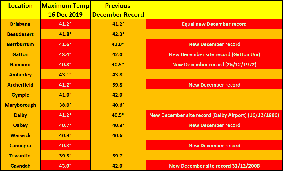
Temperatures have soared into the low 40's for numerous locations across Queensland this afternoon, with new December records being set for some sites.
Brisbane also tied for its hottest December day on record of 41.2° at 1:40pm this afternoon.
Image 1: Severe Thunderstorms - Radar Image Gympie Hailstorm 1:42pm
Image 2: Back of the hailcore of the Cooroy cell showing a strong downburst of cold air with large hail occuring inside the thunderstorm. Viewed from the south by Storm Chaser Andy Barber.
By 1:30pm, three thunderstorm cells very quickly intensified, overcoming the coastal inversion. These tracked east-northeast with the mid-to-upper level winds, towards Kandanga, Cooroy and Tewantin, posing a risk of damaging winds and large hail. By 2:07pm, Giant Hailstones (4cm+) were added into the Severe Thunderstorm Warning and it was labelled a VDS 'Very Dangerous Thunderstorm' while located near Cooran.
These storms were set to affect the area north and northwest of Noosa Heads, areas from southeast to northeast of Gympie, and Pomona - delivering large hail greater than 10cm in diameter in places. The Bureau noted confirmed hailstones of 4cm-6cms at the time. Meanwhile, 120mm of rainfall in an hour was observed associated with the slow moving northward propogating thunderstorm situated on the northern Gold Coast that contained very heavy rainfall and was producing areas of flash flooding.
Image 3: Severe Thunderstorms - Radar Image Gympie Hailstorm 2:06pm.
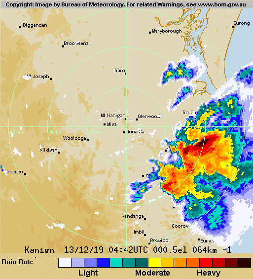
Image 4: Severe Thunderstorms - Radar Image Gympie Hailstorm 2:42pm
Severe thunderstorms including a left-moving supercell lashed southern and southwestern parts of Gympie Friday the 13th of December, 2019 delivering damaging winds and significant hail to the size of cricket balls - with reports of hail between 8cm-10cm in diameter. Very hot conditions combined with an intense upper trough created a volatile atmosphere in a conditionally unstable environment.
There was quite a strong inversion present during the morning, which essentially places a lid on convection and suppressed convective development early in the day. Usually if the strong capping is in place and then overcome, quite volatile and strong thunderstorms may ensue - and this is certainly what transpired on Friday. Low-level moisture was also a contributing factor in assisting with explosive convection, with better surface moisture present about the coastal and adjacent inland parts of the Wide Bay and Southeast Coast.
Thunderstorms initially developed south of Nanango and north of Blackbutt just prior to lunchtime, however briefly struggled in intensity. At 1:08pm, the Bureau of Meteorology issued a Severe Thunderstorm Warning for people in parts of the Wide Bay and Burnett and Southeast Coast forecast districts for damaging winds, large hail and heavy rainfall, and also added the Gold Coast due to developing thunderstorms along a slow moving northward advancing front. Damaging winds and large hail were the most likely for the Sunshine Coast, with heavy rainfall the primary threat for the Gold Coast.
Very dangerous thunderstorms continued to move north-northeast along the coastline towards parts of Goomboorian, Toolara Forest, Double Island Point, Tin Can Bay and Rainbow Beach. At 3:33pm, hailstones of approximately 8cm-10cm were observed and reported from Wilson's Pocket, some of the largest seen in the area in recent years. The hailstorm left buildings, sheds and vehicles with significant damage due to the size of the hailstones. Severe thunderstorms also began to move off bayside areas during the mid-to-late afternoon and continued to deliver heavy rainfall, accompanied by a peak wind gust of 107km/h at Redcliffe between 5:00pm and 5:04pm as the thunderstorm moved north-northeast offshore.
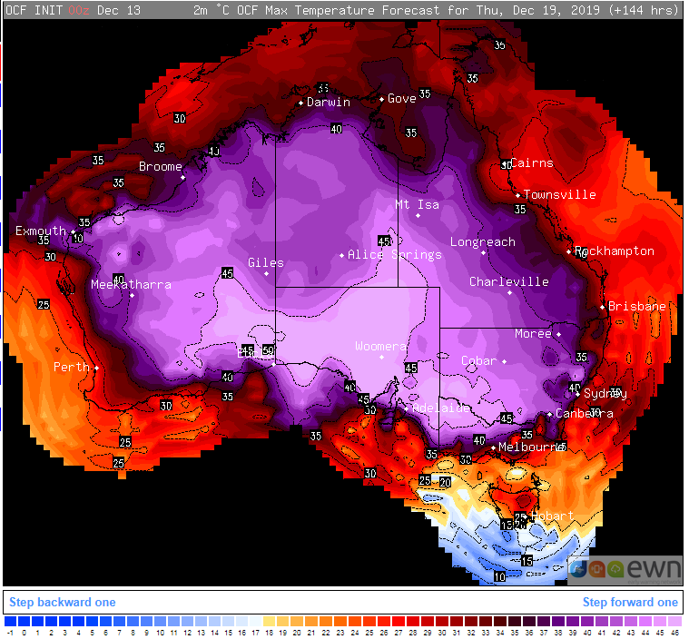
Image 1: OCF Forecast temperature for Thursday 19th December, 2019
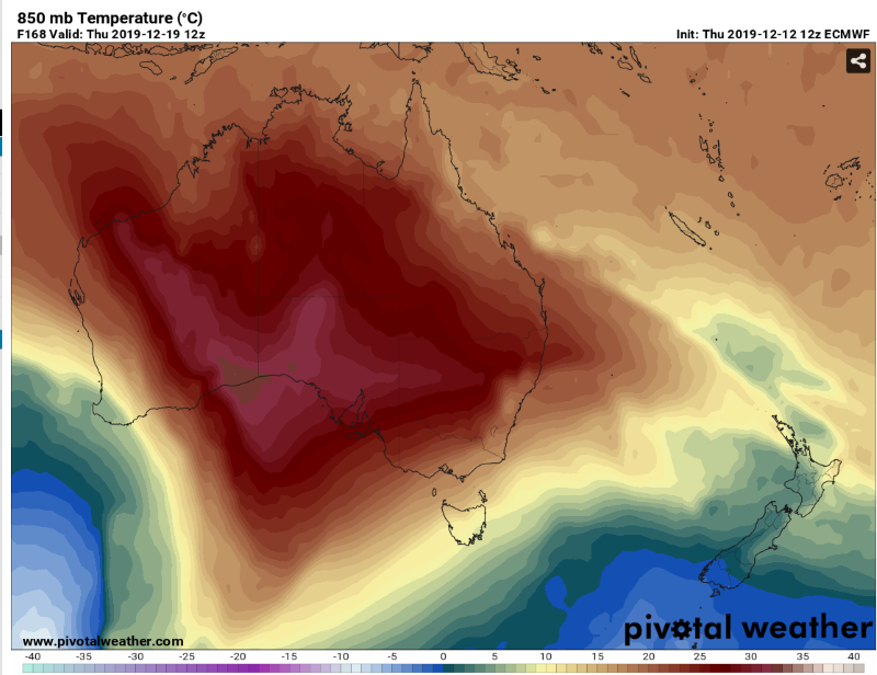
Image 2: 850 temperature forecast for Thursday 19th December, 2019 (Source: Pivotal WeatheR)
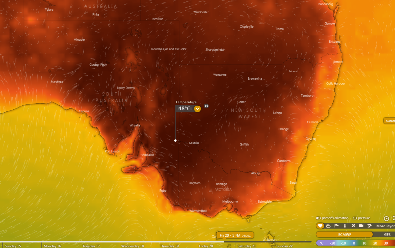
Image 3: Forecast surface temperature for Friday 20th December, 2019 (Source: Windy)
An intense wave of heat is expected to grip large parts of the country next week, with records set to tumble as temperatures approach 50 degrees in some areas.
An extremely hot airmass has been affecting the north and west of the country across the last week, and is only getting hotter as a lack of cloud cover (unusual for this time of the year) and lack of frontal activity allows the airmass to intensify.
Records have already been broken over the nation's north, with a number of locations in the northern Territory setting records for consecutive hot days, including Darwin which had its 11th consecutive day above 35 degrees today. Individual records have also been smashed, with Darwin recording a new high of 37.1 degrees on Monday, whilst Jabiru broke its previous December record (39.6 degrees) eight times over, with the hottest day in the spell so far being 41.6 ddegrees.
In Perth, three consecutive days of 40 degree heat (starting today) is forecast, and if this occurs, it will be the first time on record this has occurred in the city during December.
Over the coming days, this airmass is expected to 'spread' both south and east, particularly next week when the airmass becomes extremely hot.
From about Wednesday and into the weekend, the airmass is expected to reach its peak, with widespread areas across WA, SA, the NT and inland parts of NSW and QLD expected to at least reach the mid 40s. In some parts of SA, the southern NT and SA, the mercury will reach the high 40s, with the risk the December record of 49.5 degrees being broken on one of these days, with the 50 degrees mark not out of the question. There is also the risk the country will experience its hottest day on record.
The capital cities won't be spared, with Adelaide a good chance of breaking its December record of 44.2 degrees, and at least four consecutive days of 40 degrees plus heat. Those in the far southeast will be spared the worst of it, with Melbourne and Hobart only likely to see one extremely hot day.
Sydney will see a string of hot days, although this will be tempered by seabreezes. Western Sydney will still see a few days reaching the high 30s to low-to-mid 40s.
The only saving grace with this system, is that the east coast fire zone will be spared the hottest part of the airmass, although a number of hot, and potentially windy days are still on the cards (although there is a high amount of uncertainty at this stage). Winds overall shouldn't be as strong as they have been on other fire days this year, with no strong frontal system expected.
Longer term models don't have this intense airmass vanishing, with it likely to just retreat inland by the end of next weekend. This means any further frontal systems could drag this airmass south again, and cause more heat over the New Year period.
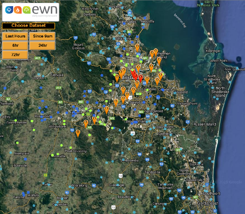
Image 1: 24 hours to 9am Rainfall - Early Warning Network Rainfall Map. *Red indicates rainfall over 100mm within a 24 hour period.
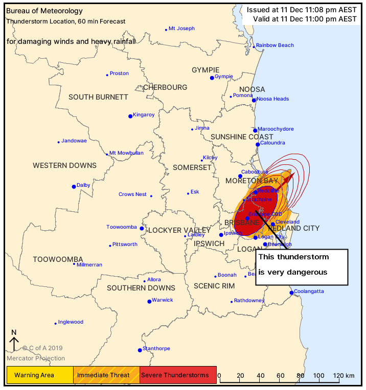
Image 2: Severe Thunderstorms Warning - Very dangerous thunderstorm over the Brisbane CBD on 11th December, 2019 warned for damaging winds and heavy rainfall.
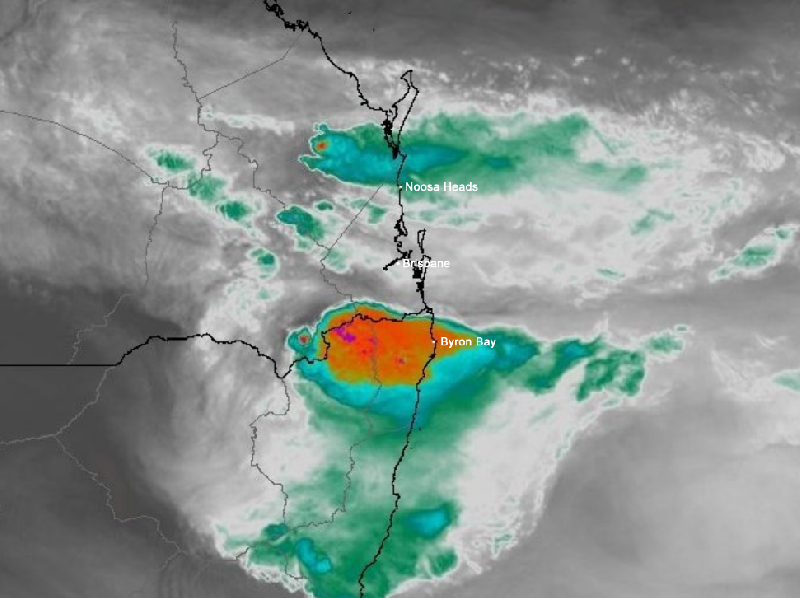
Image 3: Big boy on the QLD/NSW border - Himawari 8 Satellite Water Vapour imagery showing very large and severe thunderstorm late yesterday afternoon on the southern ranges.
Severe Thunderstorms developed through parts of the Northern Tablelands of New South Wales and also parts of the Southern Darling Downs yesterday afternoon delivering localised strong to damaging wind gusts, large hail and heavy rainfall before crossing the southwestern range of the Southeast Coast of Queensland.
At 4:06pm yesterday, the Bureau of Meteorology issued a Severe Thunderstorm Warning for Southeast Queensland for damaging winds, large hailstones and heavy rainfall. An 85km/h gust was recorded at Wellcamp Airport at 3:49pm, along with reports of large hail to the southeast of Warwick which cemented the fact damaging winds and large hail were already evident and likely should continue should thunderstorms develop further for inland and coastal parts of the southeast later in the evening. By 5:14pm, the Bureau cancelled the Severe Thunderstorm Warning however continued to monitor the approaching line of thunderstorms to the southwest of Brisbane.
At 6:38pm, another Severe Thunderstorm Warning was issued for people situated within parts of the Southern Downs Council area with again all three severe elements like in damaging winds, large hailstones and heavy rainfall. Over the course of the next hour-or-so, thunderstorms began to further intensify and attempt to cross the southern and western ranges onto the Southeast Coast. At 8:00pm, severe thunderstorms were detected on the weather radar to the area northwest of Warwick and moving towards the northeast. An hour later, people in parts of Ipswich, Logan, Scenic Rim, Southern Downs and Lockyer Valley council areas were adding into the warning on thunderstorm approach. At 9:44pm, the Brisbane City, Somerset, Redland City and Moreton Bay council areas were added into the warning.
Transmitters servicing the area of Brisbane City, Logan, Redland Bay and Moreton Bay council regions were requested to use the standard emergency warning signal before broadcasting severe thunderstorm warning information at 11:08pm for damaging winds and heavy rainfall. Very dangerous thunderstorms by this stage were detected near the Brisbane CBD and Redcliffe producing stunning rainfall rates of 89.8mm for Brisbane within one hour, with a final total of 135mm for East Brisbane (122mm in one hour). This intense rainfall rate in turn produced areas of significant flash flooding in Brisbane itself and the surrounding inland suburbs, including the bayside.
Other notable rainfall occurred at sites including but not restricted to Salisbury with 92mm, 87mm for Bulimba and Holland Park, 85mm Corinda, 81mm Toowong, 74mm Hemmant, 72mm at Gooburn and Mt Cootha, 60mm Inala, 55mm Bellbird Park and 52mm at the Brisbane Airport. These are all for a 24 hour period to 9:00am this morning, Thursday the 12th of December 2019.
The heavy deluge of intense rainfall also was accompanied by intense lightning flash rates, especially as the thunderstorm intensified on the coastal strip partially due to an increase in low-level moisture. The line of severe thunderstorms was extremely lightning active over the course of the lifecycle producing 208,000 lightning strikes and leaving 29,000 Brisbane residents in the dark.
Severe thunderstorms are again forecast today for inland and adjacent coastal inland regions of Southeast Queensland with all modes of severe weather again likely in the form of localised strong to damaging winds, large to giant hail and heavy rainfall that may be conducive to flash flooding. As always, please keep up-to-date with all severe weather alerts and information, including severe thunderstorms and bushfires via the Early Warning Network. Don't forget to check out our Significant Weather Threat Map for today's threats nationwide found here: https://www.ewn.com.au/info/significant_weather_forecast_map.aspx
Image 1: Severe Thunderstorms - December 8th, 2019 - EWN Lightning Tracker overlay with satellite imagery.
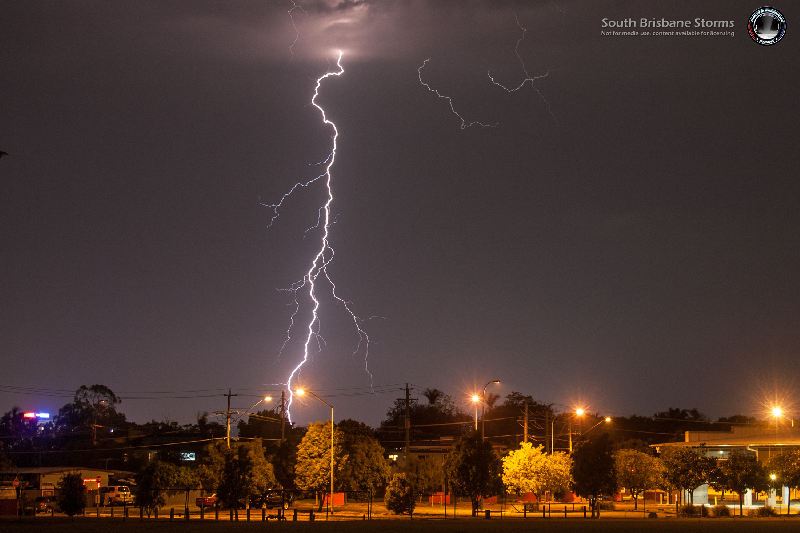
Image 2: Cloud-to-ground lightning from Springwood by EWN Forecast & Alerts Operator Andy Barber. Bolts on approach facing towards the SE.
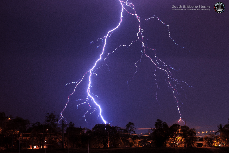
Image 3: Cloud-to-ground lightning from Springwood by EWN Forecast & Alerts Operator Andy Barber. Facing towards the east-northeast just prior to midnight.
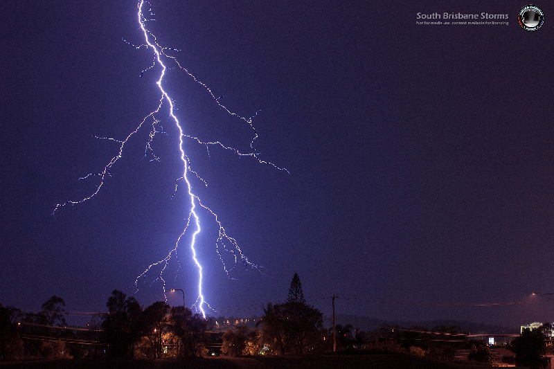
Image 4: Cloud-to-ground lightning from Springwood by EWN Forecast & Alerts Operator Andy Barber. Facing towards the east.
They've been very few and far between this storm season, but we did see a brief return to stormy skies last night as thunderstorms affected northeastern inland parts of New South Wales, the Northern Tablelands and Darling Downs and Granite Belt and Southeast QLD districts.
Very little was recorded relating to rainfall along the coastal fringe of Southeast QLD with 15mm recorded at Clearview, 14mm at the Leslie Harrison Dam and 12mm near the southern border at Springbrook with 12mm. Inland parts of the southeast did a little better with rainfall earlier in the afternoon thanks to almost stationary thunderstorms anchored atop the western ranges. Areas received in the order of 38mm at Withcotta and 27mm at Gormans Gap respectively. Over the border into northern and northeastern NSW, Lillian Rock was the alone standout with 38mm however surrounding areas barely recorded between 5mm-10mm of rainfall.
Showers and isolated thunderstorms are again on the cards again for these areas today, however may be more numerous over inland parts during the afternoon and evening where localised strong to damaging winds and large hail may be possible. Elevated thunderstorms pose great risk to the ignition of further fire in dry and tinder conditions, especially with parts of the southeast now officially draught declared. Whilst no substantial rainfall is currently in sight, I'm sure we would take as much rainfall as we can get.
Provided below are a few images from the Early Warning Networks very own Forecaster and Alerts Operator Andy Barber from Springwood, Queensland on the 10th December, 2019. These images are facing towards the east-northeast and east adjacent to the northward propagating line of thunderstorms just prior to midnight.
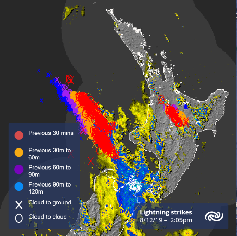
Image 1: Severe Thunderstorms - December 8th, 2019 - Lightning Tracker showing intense cold front affecting parts of New Zealand's North Island via the MetServiceNZ.
Image 2: Timaru District Council *updated* Flood Risk Map for the Rangitara River as of December 11th, 2019
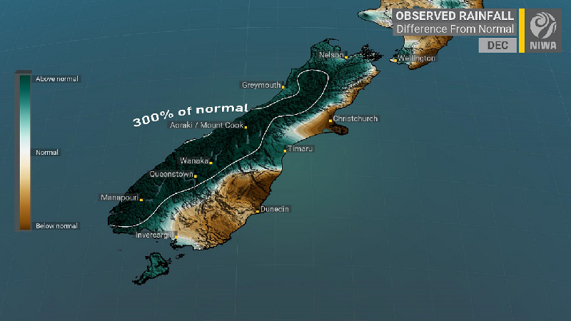
Image 3: Observed rainfall for December 2019 so far indicating up to 300% of the monthly rainfall already received via NIWA.
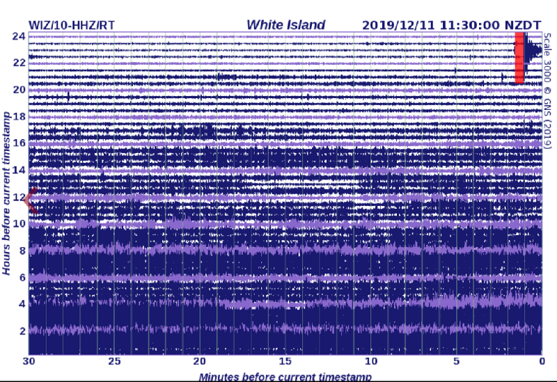
Image 4: New Volcanic tremor measured at approx. 4:00am 11th December, 2019 via GeoNet, a collaboration between the Earthquake Commission and GNS Science.
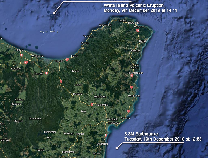
Image 5: Satellite image showing the locations, time and dates of both the volcanic eruption of the White Island Volcano and 5.3M Earthquake south of Gisbourne.
It has been a very difficult period for New Zealand over the past days with severe thunderstorms affecting parts of the North and South Island with very heavy rainfall and strong winds. Major roads were shut down including SH1 and SH6 as the torrential rainfall gave way to slips and landslides. More than 300,000 lightning strikes hit the nation and its surrounding waters during Saturday alone according to information via the National Institute of Water and Atmospheric Research Centre. Most the South Island has already received more than it's usual rainfall amounts for the month of December.
Several tourists were stranded at a campground in Whataroa, a small township on the West Coast of New Zealand's South Island, which was cut off by landslips, flooding and river washouts. A state of emergency was declared for the Timaru District during Saturday with evacuations have being ordered by Civil Defence due to the intensity of the flooding. An extended evacuation notice was also published by the Timaru District Council on the 10th of December, 2019 for changing river flows around the Rangitata Township. This is expected to be downgraded to a "Flood Risk Zone" during today, however still highly vulnerable to flooding currently.
During Monday, New Zealand's most active cone volcano - the Whakaari / White Island volcano situated in the Bay of Plenty erupted launching thick clouds into the atmosphere up to 12,000ft in height at 2:11pm (NZDT). GeoNet, which monitors geological hazards in New Zealand, had increased the Volcanic Alert Level on Whakaari / White Island to two on 18th November, 2019. The eruption was level 4 but soon dropped back to 3 which it remains at as 11th December.
Since around 4:00 am this morning, the level of volcanic tremors has significantly increased at White Island. This has been accompanied by vigorous steaming and localised mud jetting in several of the craters created by the previous eruption. GNS Science and the National Geohazards Monitoring Centre continue to closely monitor the Whakaari/White Island for further signs of activity and/or the potential for further eruptions.
On Tuesday, a magnitude 5.3 earthquake (classified as producing strong shaking) occurred at 12.58pm (NZDT) and was situated approximately 20kms south of Gisborne (offshore) with a depth of 29kms. The quake was felt in Gisborne, Wairoa, Whakatane, Cambridge, Hunterville, Dannevirke and evening in Wellington. Even though this earthquake occurred a day after the White Island volcanic eruption, these two incidents are considered to be unrelated at this stage.
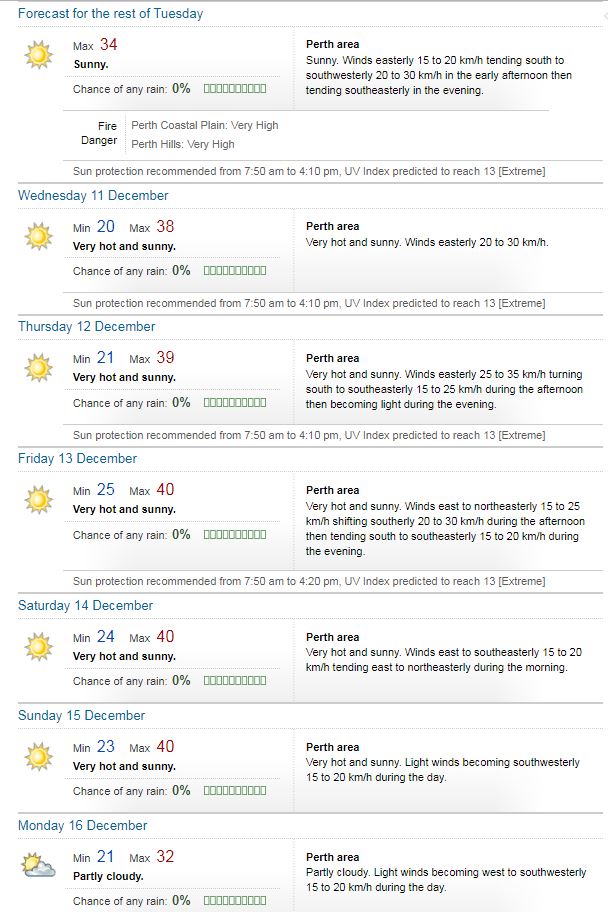
Image 1: BoM weekly forecast for Perth
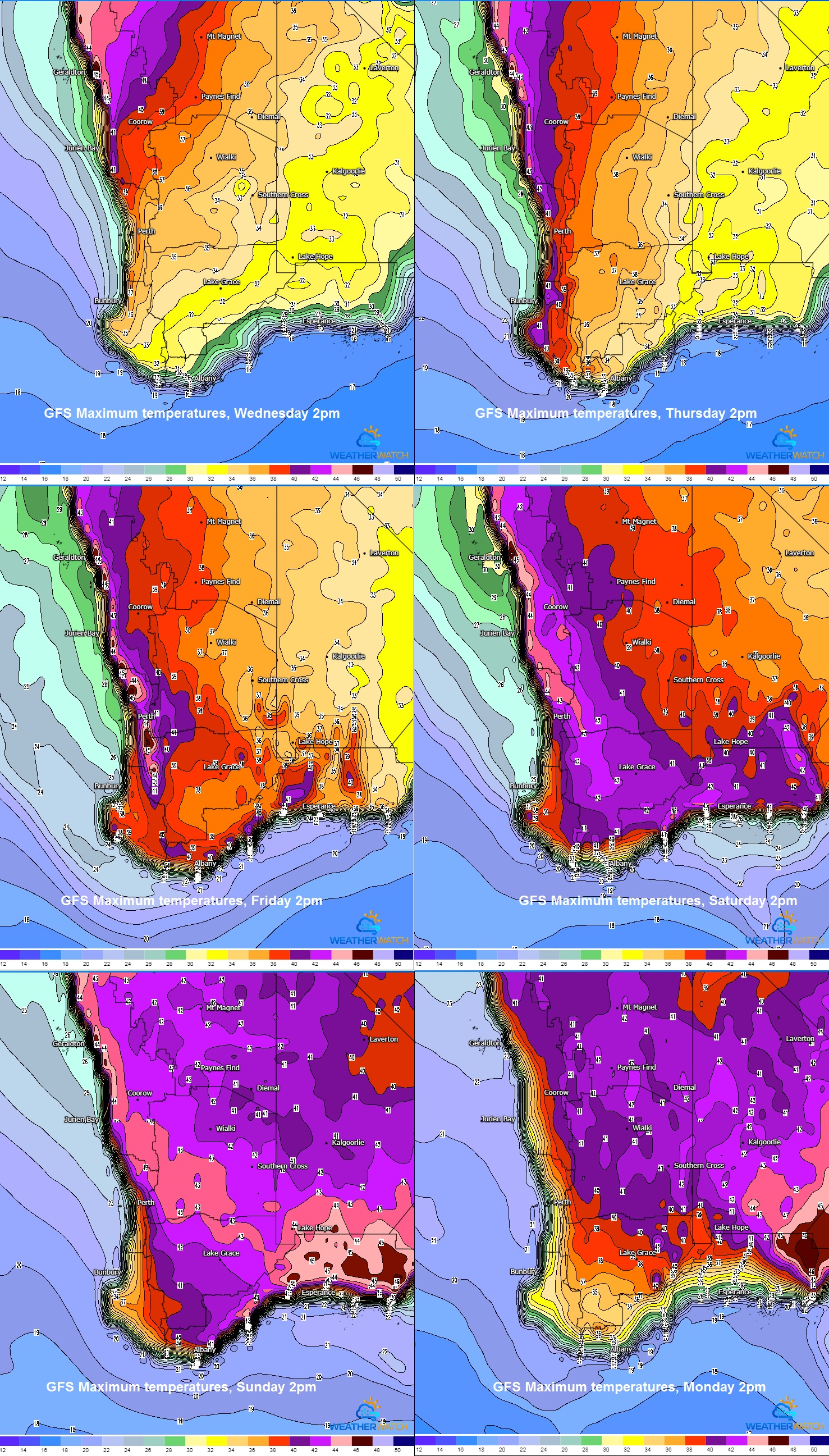
Image 2: GFS Maximum temperatures, Wednesday to Monday. WeatherWatch MetCentre
Test Cricket makes a return to Perth this week, with Australia and New Zealand fighting it out, with what is expected to be a sizzling encounter both on and off the field.
The mercury is set to skyrocket across Western Australia, with temperatures in the high 30's to low 40's for many locations over the next 7 days.
Perth's maximum temperatures are forecast to hit 34C today, 38C Wednesday, 39C Thursday before maxing out at 40C on Friday, Saturday and Sunday.
Should Perth hit 40C on Friday, Saturday and Sunday, it will be the first time in history is has registered three consecutive days at 40C or hotter in December.
Cooler westerly winds are expected to move across coastal and adjacent inland areas of the South West Land Division during Monday, with temperatures dropping as much as 10C.
Sadly, no respite is expected for inland areas, with temperatures continuing to climb into early next week. Many locations are set to see an extended period with temperatures in the mid 40's for at least the next 7-9 days.
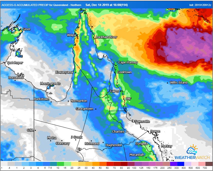
Image 1: ACCESS G Accumulated Precipitation 10/12/2019-14/12/2019. WeatherWatch MetCentre
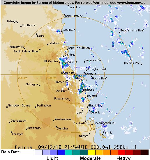
Image 2: Current 256km BoM radar showing increasing shower activity.
Widespread showers and isolated thunderstorms will develop across parts of North Queensland today, continuing through the week.
A surface trough in the Coral Sea will drift west, increasing a moist onshore flow. This will lead to scattered showers and isolated thunderstorm activity, particularly across coastal regions of the North Tropical Coast, Herbert and Lower Burdekin.
While flooding rains aren't expected, widespread falls up to 50mm can be expected for coastal and adjacent inland regions, with isolated heavier totals to 100mm possible.
Conditions should gradually ease throughout the weekend, with just a few isolated coastal showers persisting in the onshore flow.
Image 1: Previous 24hrs lightning strikes, via Landgate.wa.gov.au
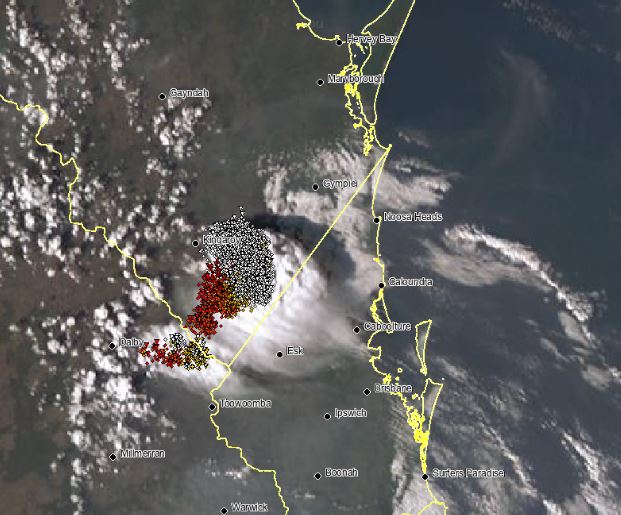
Image 2: Severe storm casting a shadow near Kingaroy. EWN satellite and lightning tracker
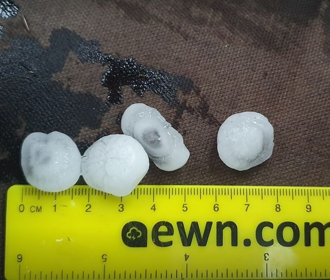
Image 3: Large hail
Scattered, tending widespread thunderstorm activity lit up parts of inland WA, north-western NT and inland QLD on Sunday afternoon.
Extremely hot temperatures gave way to severe thunderstorms across the western Top End in the NT, with a spectacular light show across the Adelaide River. Delamere in the Gregory region recorded a wind gust to 83km/h, just short of the severe threshold of 90km/h.
Near Kingaroy in southern QLD, severe thunderstorms produced hail larger than golf balls, thanks to an intense cluster of westerly building thunderstorms.
A low pressure trough across eastern-inland WA was the focus for afternoon thunderstorms for parts of the south Interior and Eucla region. High based storms across this region produced numerous cloud to ground lightning and locally damaging winds in the form of microbursts.
Storm activity is expected to continue across northern Australia during the next few days, with thunderstorm activity likely to return to eastern QLD and NSW as the system responsible for storms in WA shifts east.
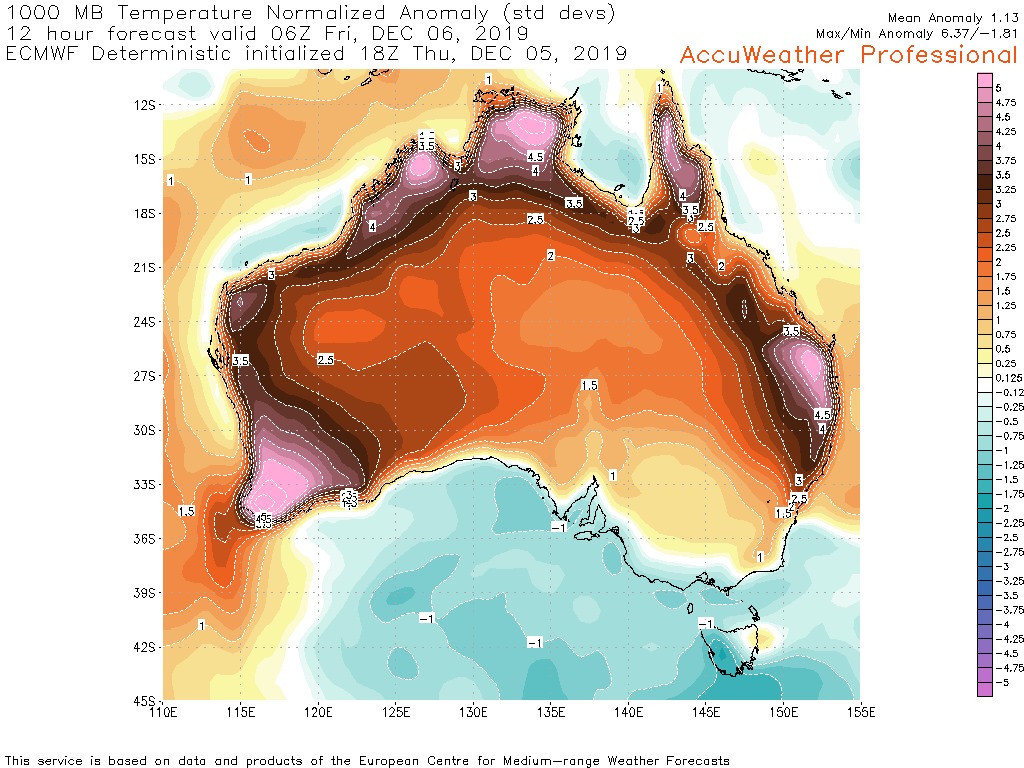
Image 1: Temperature anomolies across Australia (Source: AccuWeather Professional)
.png)
Image 2: Fires across NSW (Rural Fire Service)

Image 3: OCF Forecast temperatures across Australia on Saturday
Australia's west, north and east are sweltering through extremely hot conditions as heatwaves grip the region, with dry and gusty winds causing bushfires to burn out of control and spread quickly.
A record dry spring has allowed heat to build rapidly across the country late this year, with temperatures hitting peaks more typical of January and February rather than early December.
On the west coast, heat records have already been smashed with Perth rising to 41.6 degrees on Tuesday, the hottest it's been this early in summer. The forecast today is again 42 degrees for the city, making it the fifth consecutive day above 37 degrees. Elsewhere in the west, temperatures have been reaching from the high 30s to mid 40s.
Over the Top End and northern WA, temperatures have also been soaring to record highs. Darwin is forecast to reach 36 degrees today, just 0.8 degrees shy of its all time record. However, the city is tipped to reach the mid 30s at least for the next week (average 32.6 degrees), making it the hottest December run of heat in the city's history. Those in the rural Top End have it even worse, with the mercury reaching the high 30s to low 40s.
Over the east coast, heatwave conditions are continuing, particularly in northern New South Wales and Queensland. Brisbane is forecast to exceed 37 degrees for the third day in a row on Saturday (38), a new record for this early in summer. Ipswich sweltered into the low 40s today and is expected to reach around 43 degrees tomorrow, marking the 7th day this year the city has hit 40 degrees, a new record. Archerfield hit 40.2c degrees today, its hottest December day on record.
Bushfires continue to rage across NSW and parts of QLD, with central parts of NSW now the worst hit. A number of very dangerous blazes are burning over central NSW (close to Sydney), with a few older blazes flaring up across the north of the state as well.
Some easing of heat is likely across the west and east coasts over the weekend as winds turn more onshore, and the hottest airmass moves inland.
Those in the south will get a taste of this heat (Adelaide 37c on Sunday, Melbourne 37c on Monday), however it will be brief.
However, next week an even hotter and prolonged airmass is expected to affect the west coast, whilst heatwave conditions will again return to the east.
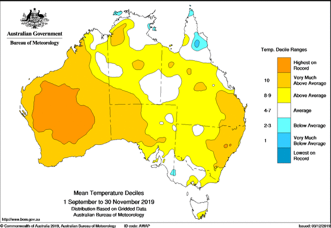
Image 1: Temperature deciles across Australia in spring 2019
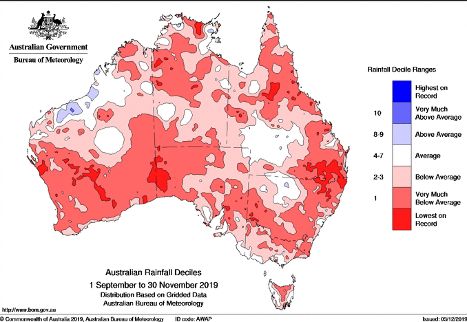
Image 2: Rainfall deciles across Australia in spring 2019
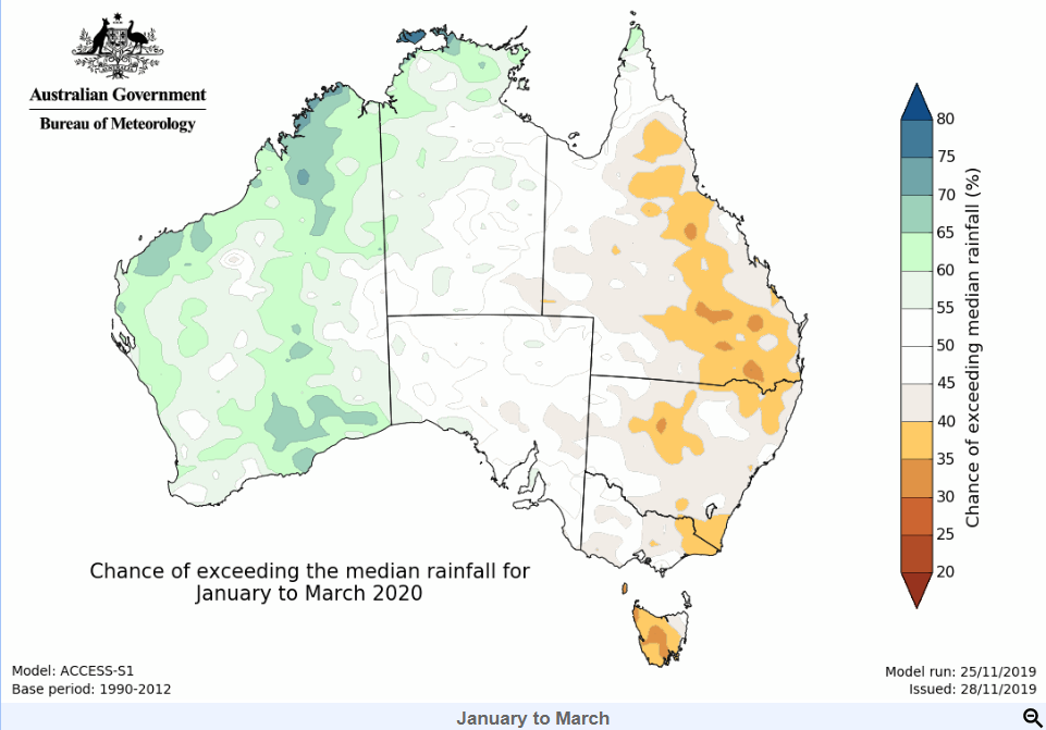
Image 3: Rainfall outlook for Australia from January to March
Spring 2019 will go down nationally as the driest spring on record (since 1900) and fifth warmest (since 1910) as severe drought conditions continued across Australia.
September was the 10th driest on record nationally, before things got worse in October which was the fifth driest nationally.
However, November came in as the driest on record nation-wide, which capped off an incredibly dry spring, with Australia now in the grips of a severe three year drought that doesn't look like breaking anytime soon.
The lack of cloud and rain allowed daytime temperatures to be well above average (+2.41c), the second warmest on record, while the minimum temperature was 0.64 degrees above average, resulting in the fifth warmest spring with maximum and minimum temperatures combined.
The main climate driver behind the big dry is a record positive Indian Ocean Dipole (IOD). In a positive IOD, cooler ocean temperatures lie over the eastern Indian (near Australia), which prevents moisture building across the west of the country. Any weather system crossing the country then is typically devoid of moisture.
While El Nino conditions were neutral, trade winds were slightly weaker than average due to the warmest waters being in the central pacific, resulting in less moisture than usual across the mainland's east. And when any moisture did try and build up, it was pushed out by strong cold fronts frequently this spring, due to a strongly negative Southern Annular Mode (SAM). Negative SAM events see the belt of westerly winds push further north than usual and stronger cold fronts, hence the early summer snowfalls over Tasmania and the alps.
Spring 2019 was also characterised by the worst bushfires in living memory along the east coast, with more than 120 fires still raging across NSW, fueled by strong and dry winds from these fronts.
The outlook for summer is for temperatures to remain above average almost nation-wide. Rainfall will continue to be low in December, however by January as the IOD breaks down, rainfall is expected to increase everywhere in the nation except the east.
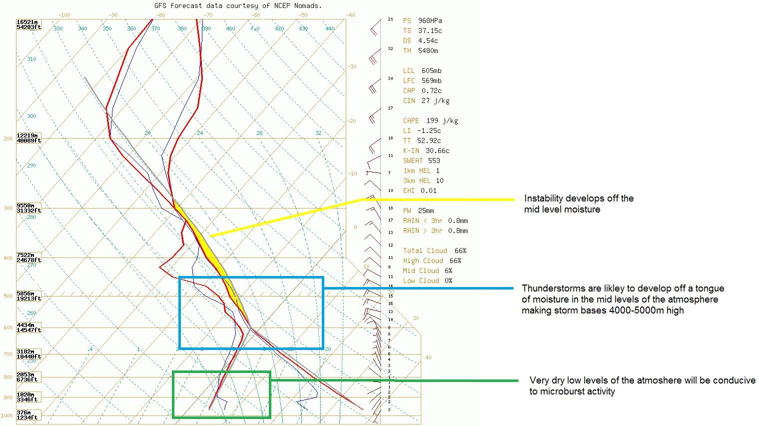
Image 1: GFS sounding and diagram explanation. WeatherWatch MetCentre
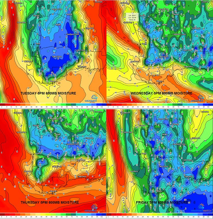
Image 2: 600mb moisture 5pm, Tuesday-Friday. WeatherWatch MetCentre
Thunderstorm activity is set to return to inland parts of the South West Land Division of Western Australia from this afternoon until the weekend.
Weak instability will develop across a low pressure trough that extends from the South West up into the Kimberley region. This will lead to the development of isolated, tending scattered showers and thunderstorms during the afternoon and evening.
Very hot conditions are expected across south-western WA during this week, with the mercury set to reach 40C in numerous locations, before a cooler change moves through during the weekend.
Due to these temperatures nearing 40C, high based thunderstorm activity is expected with little to no rainfall. Due to the high storm bases and very dry lower levels of the atmosphere, locally damaging winds in the form of microbursts will be possible with storm activity each afternoon.
Into the weekend, storm activity will slowly contract to eastern parts of the state as a cold front moves into the region, pushing the low pressure trough east.
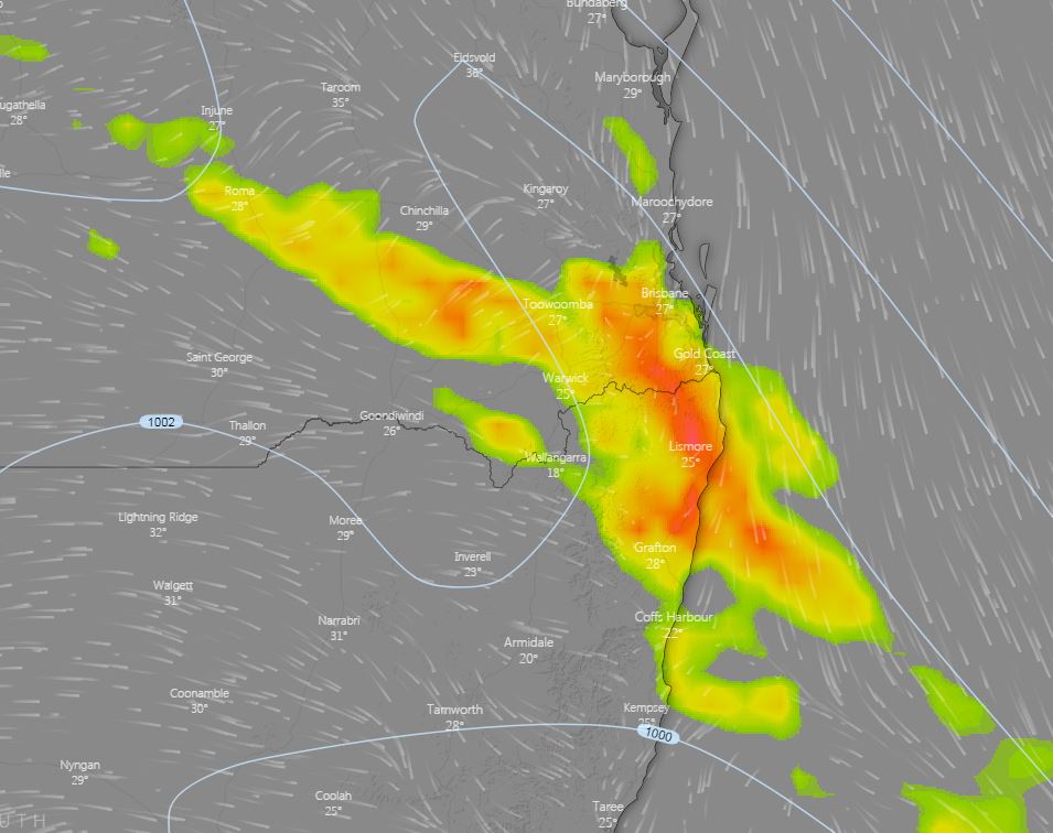
Image 1: Thunderstorm potential, 5pm Windy.com
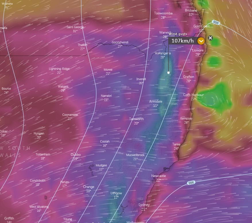
Image 2: Potential wind gusts, Monday 5pm. Windy.com
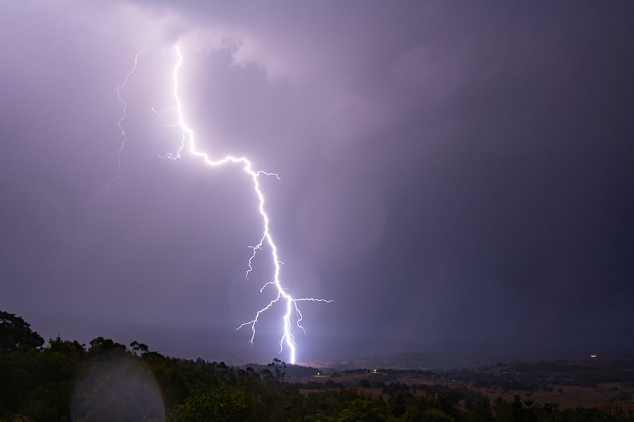
Image 3: Lightning in NE NSW 30 November by Michael Bath
Thunderstorm activity is expected to fire up across northern NSW and southern QLD during Sunday afternoon, with damaging wind gusts and fire danger returning to parts of northern NSW and southern QLD on Monday.
A surface trough extends from north-central QLD down into NSW and will be the focal point for afternoon showers and thunderstorms. Although a cloudy morning may limit storm coverage, isolated, tending scattered storms are expected to develop after lunchtime.
Bulk wind shear in the 40-50kt range will be favourable for severe thunderstorm activity, with damaging winds being the primary threat this afternoon. Locally heavy falls and large hail may develop with any organised activity that interacts with higher instability closer to the coastal fringe late this afternoon.
Overnight and into Monday, strong to damaging westerly winds are likely to develop in the wake of a vigorous cold front, with gusts of up to and exceeding 100km/h possible across parts of the Northern Tablelands, all the way down to the Illawarra region of NSW.
These winds, in combination with warm temperatures and very low humidity will lead to severe fire danger across the Northern Rivers, although recent rainfall may limit the overall fire threat.
Whilst damaging winds are not expected in southern QLD on Monday, gusts up to 80km/h will be possible across parts of the Granite Belt and higher elevation of the Border Ranges. These westerly winds will push all the way into SE QLD, potentially gusting to 70km/h. Severe fire dangers are expected to develop throughout the day.
Image 1, Current EWN Radar w/lightning overlay (12.45pm)
Image: EWN satellite image with radar and lightning overlay at 2.30pm
Image 1: Forest Fire Danger Index for South Australia for 31 October, 2019 (Source: Bureau of...