A day of weather extremes for eastern Australia
A surface trough and cold front that swept across eastern Australia during Tuesday producing an...
Unseasonable instability is set to develop across northern and inland Queensland extending into NSW next week, as a strong upper trough and cold front tracks across central Australia, interacting with increasing moisture to its east.
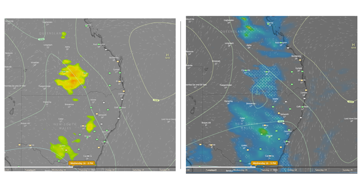
This is expected to generate a band of showers, rain periods and thunderstorm for northern, central and southern Queensland, extending south in central parts of NSW.
Strong wind shear coupled with cold temperatures aloft and unusually high levels of instability will generate a few severe storms with damaging winds, bursts of heavy rain and hail across southern-inland QLD and northern NSW. However, severe storm activity will be highly dependent on any cloud cover and rain periods across the region. Should a large rain band, (or too much cloud cover develop), this will reduce instability therefore the chance of any severe storm activity.
This system will rapidly shift east overnight Wednesday into Thursday, with showers and storms expected to push into coastal regions of Queensland, albeit in a weakening phase.
In the wake of this cold front, another blast of cold southwesterly winds is set to develop with chilly day time maximums expected to return for eastern Australia.
Image 1: ACCESS G and GFS instability levels next Wednesday afternoon. Lower the negative value, the more instability available. Image with WeatherWatch Metcentre.
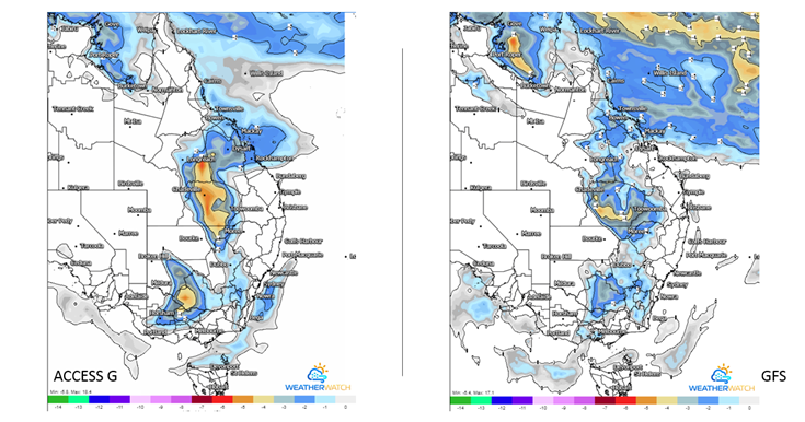
Image 2: Thunderstorm potential, and potential rain and storms next Wednesday evening. Image via Windy.com
A surface trough and cold front that swept across eastern Australia during Tuesday producing an...
This Saturday afternoon, localised showers with some possible thunder caused by a trough are...
Wet weather is expected to finally return across eastern NSW and southern QLD this week, with the...