Weather News Archive 2019 March
Image 1: BoM PME Rainfall Map QLD
A tropical low currently off the North Tropical Coast is expected to drift around erratically over water in the region for much of this outlook period while gradually intensifying.
At this stage, it's likely to reach tropical cyclone intensity by about Tuesday. The system is expected to cause some additional moderate to heavy rain along parts of the North Tropical and Herbert Coast today before becoming confined to some of the more exposed parts of the coastal fringe. This may cause some flash flooding and minor to moderate flooding of some rivers.
Gusty strong winds are also expected along parts of the coast from the North Tropical Coast to the Central coast. While they may be locally damaging, widespread destructive winds are not expected at this stage.
The cyclone is then expected to accelerate in a southeast direction while staying offshore. As it does so however, there is the slight chance of these strong winds eventually extending along exposed parts of the coast down to the Wide Bay coast later in the week.
At this stage, a major tropical cyclone impact on the Queensland coast is unlikely but it should be remembered that uncertainty with this system is currently high. Therefore just a slight deviation in its forecast track during its intensification process will cause significant decreases or increases to the potential for flooding and strong winds at short notice.
Image 1: BOM automated eight day forecast rain totals.
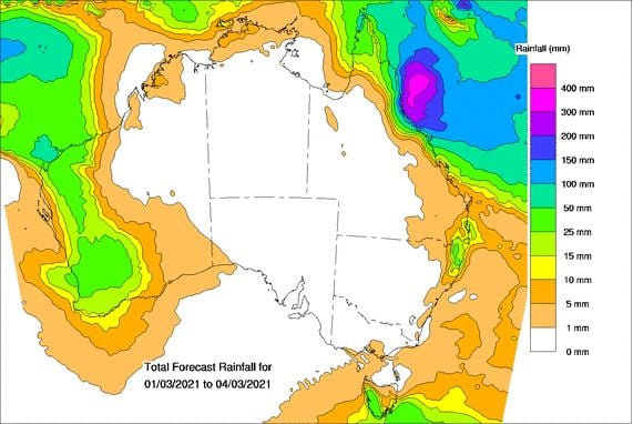
Image 2: BOM forecast track map.
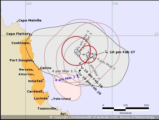
Image 1: BoM PME Rainfall Map QLD
Image: ACCESS-R accumulated forecast rainfall
Image 1: PME Total Rainfall forecast