Wet weather to return to eastern Australia
Wet weather is expected to finally return across eastern NSW and southern QLD this week, with the...
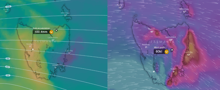
A strong low pressure system and a series of cold fronts are expected to move across TAS during Thursday and Friday.
Strong to potentially damaging wind gusts are likely to develop with the passage of the change during Thursday afternoon and into Friday, with strong north-westerly winds, turning westerly into Friday.
Thunderstorm activity is likely to approach the west coast late Thursday and overnight into Friday with the potential for a couple of storms to become severe with localised damaging wind gusts and small hail.
Widespread rainfall totals of 20-40mm are likely with isolated falls above 70mm possible which may lead to localised flash flooding and minor flooding for some locations.
Snow is expected on Friday on elevated terrain above 700m where 3 day accumulations of up to 30cm will be possible for Alpine regions.
Source: Windy.com EC model. Accumulated rainfall totals next 5 days. Surface wind gusts 1pm Friday 6th July, accumulated rainfall totals next 5 days.
Wet weather is expected to finally return across eastern NSW and southern QLD this week, with the...
18 October 2021: Severe thunderstorm potential
Of note, severe thunderstorms are already underway...