Tropical Cyclone Kimi looms large off the North Queensland Coast
Tropical North Queensland is on Cyclone watch today, as Tropical Cyclone Kimi hovers off the North...
Rainfall up to 300mm was recorded in a 24 hour period to 9:00am this morning for Nambucca Heads as a low pressure trough edged northward yesterday and overnight into the early hours of this morning. A Severe Weather Warning for Heavy Rainfall, Damaging Winds, Abnormally High Tides and Damaging Surf is current for people situated within the districts of Northern Rivers and the Mid-North Coast.
Heavy rainfall is expected to further increase the risk of flash flooding and rises in creeks, streams and estuaries. High water levels due to spring tides are also forecast over the next few days, which adds to the risk of flooding in lower tidal areas. Flooding is anticipated to be evident in the following catchments from today and leading into early next week: Tweed and Rouse Rivers, Brunswick River and Marshalls Creek, Wilsons River, Richmond River, Orara River, Coffs Coast, Nambucca River and the Hastings River.
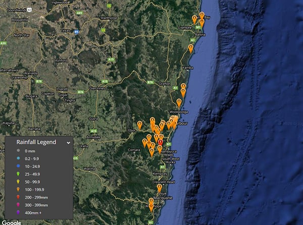
A moderate to major Flood Warning is current for the Bellinger River in response to significant rainfall totals recorded overnight. Some of the rainfall totals over 100mm within 24 hours to 9:00am include 300mm Nambucca Heads, 203mm Bowraville, 161mm Crystal Creek, 160mm and both Missabotti and Utungun respectively, 154mm Dorrigo and Coffs Harbour, 152mm Thora and Boambee, 150mm Middle Boambee, 137mm Gleniffer, 136mm Bowra, 133mm Pillar Valley and Minnie Water, 129mm South Arm, 122mm Girralong, 121 Coopers Shoot, 120mm Lake Ainsworth, 118mm Meldrum, 112mm Evans Head, 108mm Wooli, 106mm Thumb Creek, 101mm Taylors Arm and 100mm recorded at Nashua.
Further moderate to heavy rainfall areas are expected to continue into tomorrow, especially for parts of the Northern Rivers and extending into southeastern parts of QLD. Heavy rainfall areas may occur about the coast relative to adjacent inland districts. Localised moderate to heavy rainfall areas producing totals of up to where between 100mm-150mm within a 24 hour period may occur leading into Monday, elevating the risk of flash flooding with creek and river rises possible. Rainfall is expected to ease leading into Tuesday with the westward progression of the surface trough.
Image 1: NSW locations that received >100mm of rainfall since 9:00am yesterday to 9:00am 12th December 2020.
Tropical North Queensland is on Cyclone watch today, as Tropical Cyclone Kimi hovers off the North...
Some isolated but very heavy rain around the Sydney basin last night, mainly over the North Shore,...
The wet season continues to deliver for parts of the northern and central Queensland coasts with...