Severe frost hits southeastern Australia
Parts of southeastern Australia have just shivered through their coldest August morning in almost a...
Showers, isolated thunderstorms, and gusty winds are expected to develop for western parts of South Australia Tuesday morning, before shifting across central and southeastern parts during the evening hours into Wednesday morning as a low pressure system and cold front traverse southern Australia.
Whilst widespread significant rainfall isn’t expected, 5-15mm will be possible, with isolated heavier falls to 25mm.
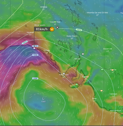
Gusty winds will wrap around the wester periphery of this low, with gusts of 50-60km/h expected, particularly for exposed coastal locations and elevated terrain late Tuesday into Wednesday.
Isolated thunderstorms will develop for coastal regions during the day, spreading into the southeast of the state into Tuesday evening. Strong winds and bursts of heavy rain will accompany any thunderstorm activity.
Image 1: Bureau of Meteorology predicted rainfall for Tuesday 15/06/2021
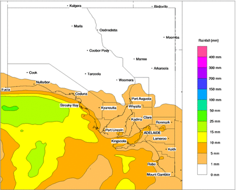
Image 2: EC wind gusts Tuesday evening. Image via Windy.com
Parts of southeastern Australia have just shivered through their coldest August morning in almost a...
Wild weather hit southwestern parts of Western Australia on Tuesday afternoon and evening and into...
Temperatures plumetted on Thursday morning across Australia's southeast as the mercury approached...