Solid rain on the way for NSW and QLD
Shower activity increased across eastern NSW and QLD during Wednesday with 10-20mm falling across...
18 October 2021:
Severe thunderstorm potential
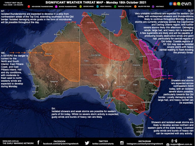
Of note, severe thunderstorms are already underway across eastern Qld.
QLD/NSW: Widespread thunderstorms are expected across eastern Qld today, with numerous storms likely to be severe. Damaging winds, large hail, and heavy rainfall leading to flash flooding are likely, particularly for parts of the Capricornia, Wide Bay and Burnett, eastern Darling Downs and western South East Qld. A few supercells are possible with locally destructive winds, giant hail and heavy rainfall, particularly for central Qld, extending into the southern Wide Bay and northern Darling Downs this afternoon. One or two severe storms may spill into northern NSW throughout the day.
Tomorrow, Tuesday 19th October: scattered storm activity is expected to continue across the eastern seaboard, with a few storms expected to reach severe criteria. The coastal fringe from Bowen in Qld to Grafton in NSW will be an area of interest. Locally damaging winds, large hail and heavy rainfall can be expected with any severe activity.
Contact us if your organisation is looking to minimise risk against severe weather and natural hazards.
We have climate risk data to empower your business with all the intelligence needed to make informed decisions and assess the risk to regional scale changes in climate.
Shower activity increased across eastern NSW and QLD during Wednesday with 10-20mm falling across...
Wet weather is expected to finally return across eastern NSW and southern QLD this week, with the...
After knocking out power and damaging homes across Adelaide last night, a complex low pressure...