Heavy rain drenches Victoria and the ACT as widespread rain and storms hit southeast Australia
Rain and thunderstorms swept across southeastern Australia last night, producing widespread rain...
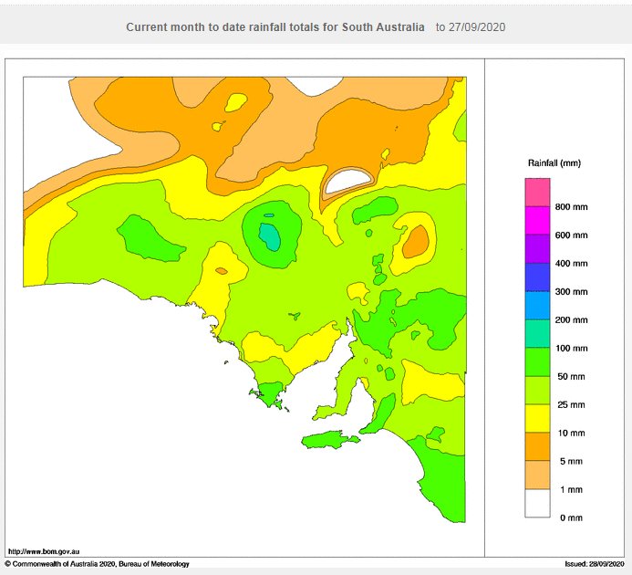
Rain and thunderstorms are set to spread across parts of South Australia over the next two days, to cap off what has been a warm month but also the wettest September for the state since 2016.
A low pressure trough is combining with a humid northeasterly flow to generate showers and thunderstorms across the state's northwest this afternoon and evening. Some of these storms may become severe due to strong wind shear, and bring the risk of large hail, damaging winds, frequent cloud to ground lightning and strong wind gusts, however due to the low population density in this region damage is unlikely.
These storms will persist overnight and spread gradually southeast, tending more to rain areas as the system moves south. Whilst potentially severe storms will persist over the far north of the state on Tuesday, rain areas will gradually spread across central and southeastern parts of the state (including Adelaide), before clearing away during the evening or early Wednesday morning.
The northwest of the state will see the heaviest falls, with many areas likely to see 10-20mm, but up to 40-50mm under showers and thunderstorms. Across central and southeastern parts of the state, falls of 5-10mm will be more commonplace, with some areas seeing 15-20mm.
The rain will cap off what has been the state's wettest September since 2016. Many parts of the south have recorded close to their average rainfall for the month, whilst some parts of the central and north have recorded well above their average September totals, such as Maree that has recorded more than 9 times its September average (93mm for the month, compared to a 10mm average).
The month has also been warm, with the state likely to register one of its warmest Septembers on record (and warmest since 2013), with many parts of the state two to three degrees above average.
Looking further ahead, October is likely to begin on a warm note however there is growing consensus of widespread rainfall across the state within the first week of the month.
Image 1: Accumulated precipitation across the next 48 hours from the GFS Model (Source: Weatherwatch Metcentre)
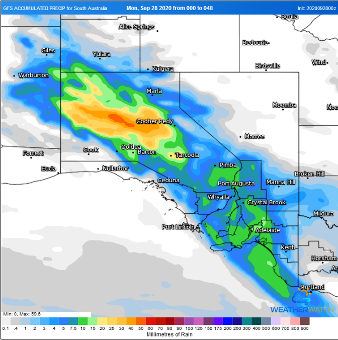
Image 2: Rainfall for September 2020 to date across South Australia (Source: Bureau of Meteorology)
Rain and thunderstorms swept across southeastern Australia last night, producing widespread rain...
A series of active fronts swept across the South Island yesterday and is set to continue today...
Whilst southeastern Australia is set to shiver this week, another round of wet weather is set to...