Record heat waves and fire weather gripping Australia's west, north and east
Australia's west, north and east are sweltering through extremely hot conditions as heatwaves grip...
Sizzling heat and catastrophic fire danger is affecting Australia's interior as the mercury soars above 40 degrees, however those in the tropics are shivering through uncharacteristically chilly nights.
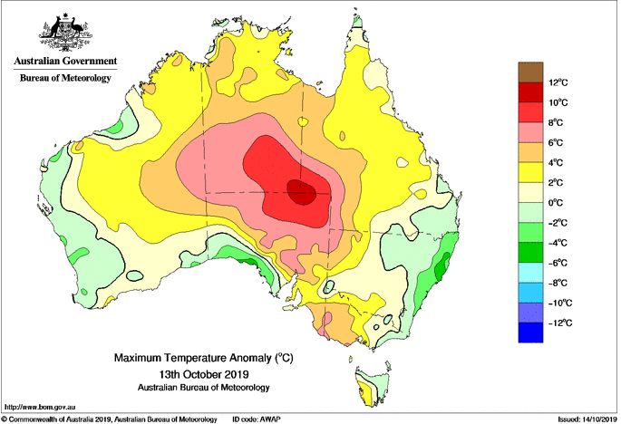
Unseasonably hot conditions are affecting inland Australia, with temperatures soaring up to 10 degrees above average. Alice Springs is forecast to reach 39 degrees today and 40 degrees tomorrow (after similar temperatures the last two days), putting the inland city on track to register its hottest October on record.
A little further west, over the WA interior and far southwest NT, strong winds are combining with this heat to produce catastrophic fire conditions, although thankfully vegetation in this part of the world is sparse.
However, over the northern tropics conditions have been quite different, particularly at night. Daytime temperatures have been mostly average to above average, however the night times are tracking two-to-four degrees below average for the month so far, with some short term sites possibly heading towards their coolest October nights on record.
On Sunday morning, Groote Eylandt dipped to just 11.8 degrees, 9 degrees below the average of 20.9 degrees, whilst on Saturday morning Daly Waters dipped to 11.5 degrees, almost 10 degrees below average.
Those over north Queensland who saw some of their coldest September nights on record continue to feel the chill this month too, with many sites running two-to-three degrees below average for October.
The reason for the cold nights further north has been the below average humidity, with widespread drought conditions gripping the nation, and strong cold fronts pushing this dry air well into the tropics.
Unfortunately, these are poor signs for the wet season ahead, with dry conditions and cool nights lasting this late in the year generally a sign that the monsoon will be delayed or weak, which is bad news for a nation in desperate need for rain.
Image 1: Minimum temperature anomolies for the week ending 13 October, 2019
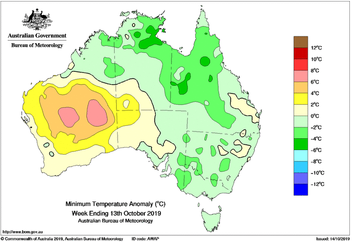 Image 2: Maximum temperature anomoly for 13 October, 2019
Australia's west, north and east are sweltering through extremely hot conditions as heatwaves grip...
Widespread follow up rain, strong winds and thunderstorms are likely over the next few days across...
The strongest cold front of the year is set to sweep across Australia's southeast from Wednesday,...