Late season cold snap for southeastern Australia
A late-season cold snap is developing across southern Australia, producing showers, thunderstorms,...
A front is set to cause heavy rain over the western South Island on Friday, with falls in excess of 200mm possible in some areas bringing the risk of landslips and flooding.
The front is feeding off a vast supply of moisture not only sourced from the Tasman Sea, but also the Indian Ocean as a thick northwest cloudband causes heavy rain across Australia as well, with moisture being streamed southeast by a strong subtropical jet.
Heavy rain warnings are in force for Westland and Fiordland, extending inland to the headwaters of the Otago lakes and rivers and the Canterbury headwaters about and south of Arthurs Pass, with a severe weather watch for heavy rain also extending to Buller. Widespread totals of 120-180mm are expected to accumulate, with up to 220mm in Fiordland. The majority of this rain is expected to fall on Friday, with potential for rapid rises in streams and rivers leading to flooding, landslips and hazardous driving conditions. A warm airmass will mean a lot of this rain will not fall as snow, even about alpine areas, with the rain likely to add slush to the ski slopes away from the peaks.
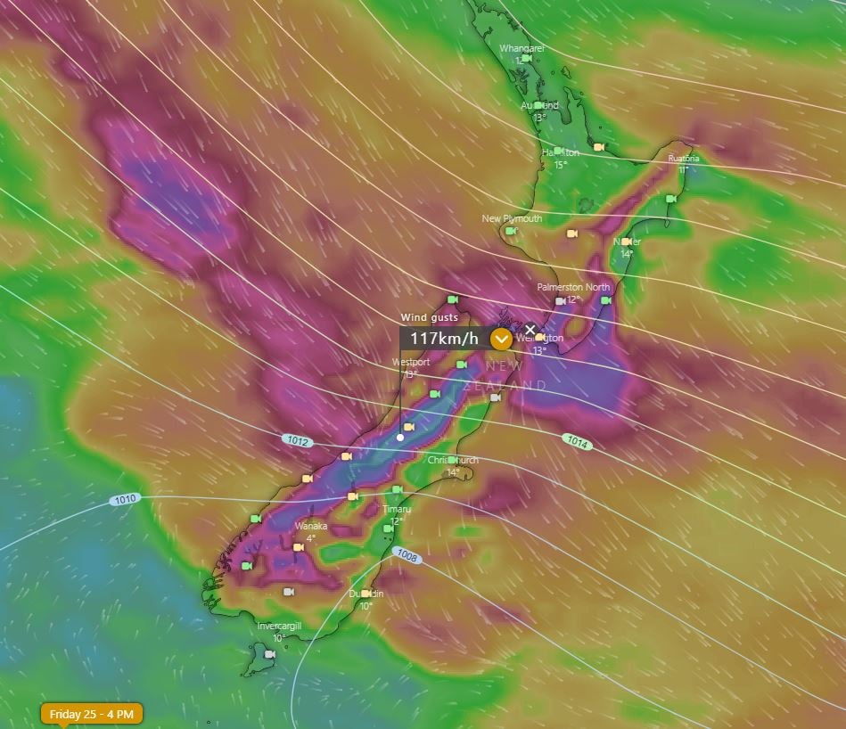
Northwest gales may also develop, with severe weather watches in force for the Canterbury High Country and Wellington, Wairarapa, and the Marlborough Sounds with wind gusts approaching 120km/h, particularly in alpine areas.
Conditions will ease a little over the weekend, although winds will remain strong around Wellington on Saturday, and over central and northern parts of the North Island on Sunday. Wet conditions are likely to persist, particularly on Sunday. A strong cold front later on Sunday and into Monday will bring a fresh dumping of snow to the South Island, making up for snow loss due to the rain on Friday with up to 50cm of fresh snow expected.
Image 1: GFS Accumulated precipitation over the next 72 hours (Source: Weatherwatch Metcentre)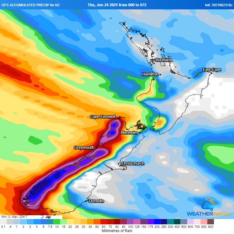
Image 2: Wind gusts at 4pm AEST (6pm local time) on Friday 24 June, 2021 from the ECMWF Model (Source: Windy.com)
A late-season cold snap is developing across southern Australia, producing showers, thunderstorms,...
A strong cold front is beginning to move across southeastern Australia, causing strong northerly...
A strong cold front is dragging a hot airmass and strong winds once again over southeastern...