Fires, severe thunderstorms and damaging winds lash NSW
It was a testing Thursday for emergency services across New South Wales as fires, dust and strong...
Whilst southeastern Australia is set to shiver this week, another round of wet weather is set to impact the South West Land Division of WA, including Perth.
A low pressure system in the Indian Ocean is set to deepen over the next 24 hours, before drifting in a southeasterly direction towards the Western Australian coast.
A frontal system will extend north from this low, with a band of showers, rain periods, and isolated thunderstorms expected to impact the western Pilbara and Gascoyne coasts during Wednesday morning, extending into the South West Land Division.
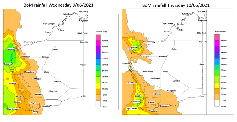
Widespread falls of 5-15mm will be possible on Wednesday, with isolated falls of 20-30mm possible for some locations.
Late Wednesday night into Thursday morning, the low will approach parts of the South West District with a stronger band of heavy showers and thunderstorms. Locally damaging wind gusts are also expected to develop for this region, particularly for areas from Mandurah – Bunbury – Busselton – Augusta. Gusts of up to 90km/h will be possible, particularly with any thunderstorm activity.
This second band of activity may produce another 10-20mm, with isolated falls approaching 30mm for some locations.
Image 1: EC wind gusts 3am Thursday 10/06/2021. Image via Windy.com
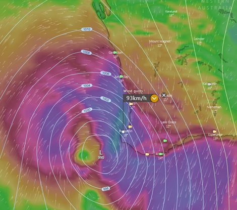 Image 2: BoM forecast rainfall for Wednesday and Thursday 9/06/2021 – 10/06/2021.
It was a testing Thursday for emergency services across New South Wales as fires, dust and strong...
A series of active fronts swept across the South Island yesterday and is set to continue today...
Yet another heavy rain event with flooding potential is aiming its sights on the southern coast of...