Intense rainstorms bring flash flooding to parts of coastal and inland Southeast Queensland
An inland trough was the catalyst for severe thunderstorm activity, which tracked across the...
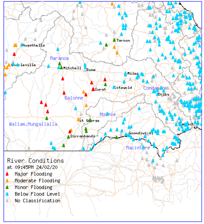
Major flood warnings are currently in effect for people situated close or near to the Wallam and Mungallala Creeks, Warrego River, Pardoo River and Eyre Creek. Flood waters are still rising in some locations across inland southern Queensland and are expected to peak over the next few days, however there is little change relating to further significant rainfall in the catchments prompting the Bureau of Meteorology to cancel the Flood Watch for Queensland earlier this afternoon.
Detailed below in red are the rivers that are currently in major flood, with the vast majority situated concentrated around Charleville, and also through central and southern parts of the Warrego and Maranoa district. Some of the river information and heights in and/or adjacent to populated regional areas are as follows:
Image 1: Southern QLD river conditions on Tuesday, February 25th 2020 via the Bureau of Meteorology.
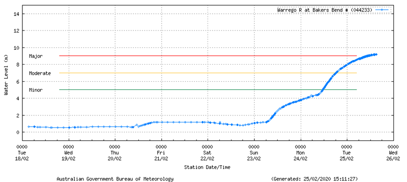
The Warrego River at 27 Mile Garden currently sits at 4.36m as of 25/02/2020 at 15:07 and is currently continuing a falling trend. The major flood level is at 4.00m with the bridge at 4.3m in height. The Warrego River at Bakers Bend to the south of Charleville currently sits at 9.21m as of 25/02/2020 at 15:38 showing a rising trend. The major flooding level for this location is 9m.
Image 2: Warrego River river level at 27 Mile Garden, QLD. Tuesday, 25th February 2020.
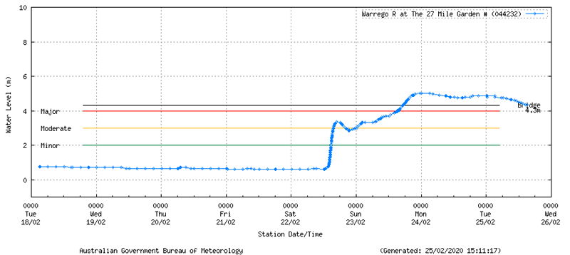
Image 3: Warrego River river level at Bakers Bend, QLD. Tuesday, 25th February 2020.
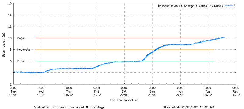
The Balonne River at Surat currently sits at 9.73m as at 25/02/2020 at 15:00 and is currently on a rising trend. The major flood level at this location is at 8.80m with the bridge at 10.8m in height. The Balonne River at St. George currently sits at 10.4m as of 25/02/2020 at 15:00 and is showing a rising trend. The major flood level for this location is 10m.
Image 4: Balonne River at Surat, QLD. Tuesday, 25th February 2020.
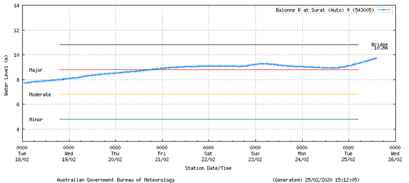
Image 5: Balonne River at St. George, QLD. Tuesday, 25th February 2020.
Some locations have received significant rainfall over the past seven days resulting in further flash flooding over already saturated catchments. Some locations have recorded over 400mm of rainfall the past seven days to 9:00am, 25/02/2020 and include 402mm at Rollingstone, 366mm at Mornington Island, 366mm at Port Douglas, 322mm at Sweers Island, 319mm at Westmoreland, 318mm at Mount Charlton, 283mm at Allingham, 278mm at Gairloch, 273mm at Bambaroo, 259mm at Aurukun, 227mm at the Mackay Airport, 255mm for the Mackay Racecourse, 249mm at Hamilton Island and 212mm at Ingham.
Some locations to have received notable rainfall over a 24 hour period to 9:00am this morning have included 116mm at Rollingstone, 92mm at Noosaville with 84mm falling at Tewantin, 66mm at Hughenden, 57mm at Pacific Heights, 55mm at Alva Beach and 41mm recorded at Mount Dougla and 28mm at Canungra.
An inland trough was the catalyst for severe thunderstorm activity, which tracked across the...
Significant rainfall has been recorded yesterday and overnight for the northern tropical coastal...
It’s rinse and repeat for inland Australia, with the third flood event of 2024 inundating western...