Showers and storms to develop for eastern Australia
Wet conditions are likely to develop across southern and eastern Australia later this week and...
A series of cold fronts are set to batter southeastern Australia across the next week, bring a slew of wet and windy days, and priming the ski resorts for their best weeks this season.
The Southern Annular Mode (SAM), which is related to the location of the belt of westerly winds, has shifted into a negative phase after being largely positive the last two months. When the SAM is positive, the belt of westerly winds move south away from Australia, and has been a big reason why June and July have been warm and dry across the country.
As the SAM has dipped into a negative phase, cold fronts will increase in frequency across the country for at least the next week, and bring a burst of wintry weather and showers to the nation's southeast.
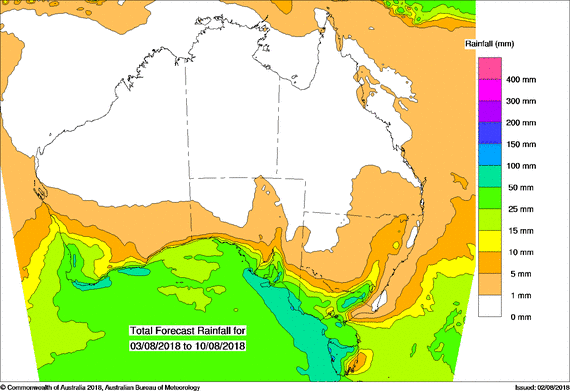
The first of these fronts crossed the region today, bringing much needed rain to South Australia and Victoria with widespread falls of 5-15mm, and some places collecting as much as 30-40mm.
Another, although slower moving front will cross the nations south across the weekend and into early next week, bringing scattered showers, gusty winds, isolated thunderstorms with small hail and snow about alpine areas. There is potential for further useful rainfall totals with this system, especially about southeastern SA, western Victoria and western and northern Tasmania (where further flooding is possible after a damp winter already).
Another weaker front will push through mid-week, before another system is expected to arrive during the weekend, although these systems are not expected to be overly strong. However, they will all contribute to further topping up the ski resorts, with parts of the NSW and VIC alpine areas expected to approach 2 metres by next weekend.
SAM is very hard to predict more than a couple of weeks in advance, so it is hard to know how long this burst of frontal activity will last. Unfortunately, drought affected eastern Australia won't see much in the way of rain from these cold fronts at all.
Image: PME rainfall forecast across the next week over Australia (Source: Bureau of Meteorology)
Wet conditions are likely to develop across southern and eastern Australia later this week and...
An extremely hot, dry airmass that moved over eastern Australia, combined with gale force westerly...
Parts of Victoria, NSW, SA and Tasmania are expected to experience damaging to locally destructive...