Strong cold front to bring low-level snow to New Zealand
A strong cold front will sweep across New Zealand from this evening, bringing bitterly cold...
A strong cold front is beginning to move across southeastern Australia, causing strong northerly winds ahead of it and wet, cold and windy conditions with and behind the frontal boundary.
The front, which brought widespread rain, small hail and even some snow about Bluff Knoll in Western Australia is currently lying over western parts of South Australia (as of Monday afternoon), with strong northerly winds ahead of the system.
A severe weather warning for damaging winds of 90-100km/h is current for SA's Lower Eyre Peninsula, Eastern Eyre Peninsula and parts of West Coast, Yorke Peninsula and Kangaroo Island today, with strong winds likely to persist into tomorrow. A severe weather warning is also current for wind gusts to 90-100km/h over the Central and parts of South West, North Central and West and South Gippsland Forecast Districts in Victoria, developing from tonight about Victoria's central highlands, and elsewhere on Tuesday morning. These strong winds are also expected to affect parts of Tasmania on Tuesday as well.
Areas of rain will develop over western SA this afternoon and evening on the pre-frontal trough, before spreading across the remainder of SA overnight and into Tuesday morning, and then Victoria and Tasmania on Tuesday. For coastal areas of SA, parts of Victoria and northern and western Tasmania, widespread falls of 10-20mm are likely with some areas likely to see totals of 30-50mm, mainly those in exposed elevated areas. For some areas, such as Adelaide this is likely to be the best rain since mid summer.
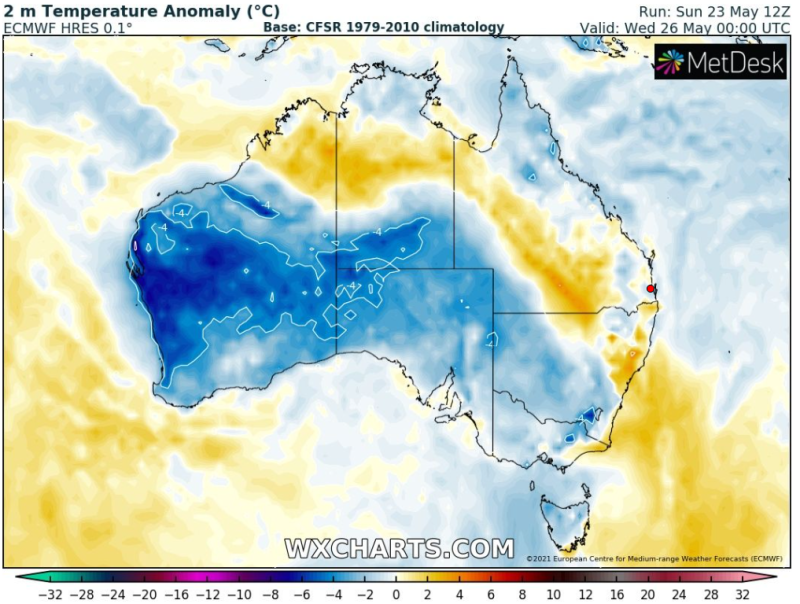
In the wake of the front, wintery conditions are likely with temperatures ranging from the low to high teens across the southeast. Melbourne is expected to only reach 15 degrees for several days running, from Wednesday through until at least Sunday, with chilly nights developing over the weekend as skies clear. Only light snowfalls are expected about the Victorian alps and NSW Snowy Mountains, with most of the rain falling when the airmass is too warm. However, cold nights in the wake of the front will create ideal conditions for snowmaking.
Image 1: Accumulated precipitation across the next 72 hours for southeastern Australia for the GFS Model (Source: Weatherwatch Metcentre)
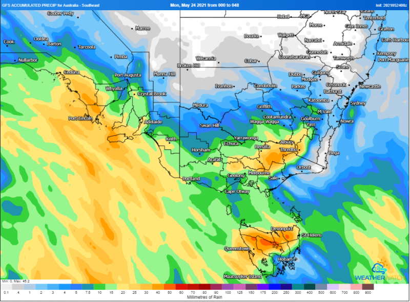
Image 2: Temperature anomaly for Wednesday 10am across southeastern Australia, showing the effects of the cool change over the country (Source: Wxcharts.com)
A strong cold front will sweep across New Zealand from this evening, bringing bitterly cold...
A strong cold front is dragging a hot airmass and strong winds once again over southeastern...
Winter is set to briefly depart from Queensland over the next few days, as a low pressure trough...