Large surf to smash NSW coast
The New South Wales coastline is set to be smashed by huge surf tomorrow, with waves set to reach...
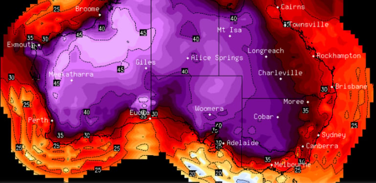
The vast majority of Australia is set to scorch across the Christmas/New Year period as a heatwave grips the nation with records set to be challenged.
Inland areas have been sweltering already for more than a week, with northwest Australia enduring a continued run of temperatures in the mid-to-high 40s. Bourke also reached 47 degrees and Alice Springs fell just shy of its December record (44 degrees) mid last week.
This heat spilled south over the weekend in the west with Perth reaching 41 degrees on Saturday, and is now set to spread into the nation's southeast, where it is set to sit over the Chrismas and New year period and well into the first week of January.
While this will be great for holiday goers in coastal areas as the warm weather and sunny skies will make for great beach weather (and the heat will be tempered by seabreezes), as well as meaning that Christmas and New Years plans are unlikely to be washed out due to rain in most areas, inland areas are set to scorch with December records under threat, particularly for consecutive hot days.
Mildura is expected to hit 40 degrees on at least six consecutive days, eclipsing the previous record of five days in 1931, and will reach the mid 40s by the end of the month. By late December, many inland areas will see a continued run of temperatures in the low-to-mid 40s, with Alice Springs set to challenge its December record again on consecutive days.
Adelaide and Canberra will feel the worst brunt of the nation's capitals, with Canberra set to challenge its December record on multiple days, soaring into the high 30s by late this month. Adelaide will see heat in the mid 30s (including at least one day in the low 40s) into early January. Other capitals will be spared the worst heat due to either weak cold fronts or seabreezes with the hottest days limited to a couple of days or limited to the early 30s (as opposed to the 40s), although western Sydney will see consecutively hot days in the high 30s and early 40s
Gusty winds may also develop in some parts of the south after Christmas, bringing the increased risk of bushfires towards New Years.
With a positive Southern Annular Mode (which controls how far north cold fronts can reach), there is little relief in sight. There are some indications of cooling across the country around the second week of January as frontal activity and moisture increases, leading to increased cloud cover, however temperatures are still expected to remain above average.
Image 1: National Temperature Maximum Forecast Map
The New South Wales coastline is set to be smashed by huge surf tomorrow, with waves set to reach...
A series of cold fronts are set to batter southeastern Australia across the next week, bring a slew...
The east coast has made headlines for its bushfires in recent months, however the fire danger is...