Serious Flooding Threat for SE QLD
South East Queensland is on flood alert with a significant rain event developing.
A strong upper...
A trough in the west generated a band of mid-level thunderstorms across the Wheatbelt region of Western Australia overnight, with an incredible August light show.
Over 20,000 lightning strikes were recorded overnight as an impressive line of thunderstorms progressed east into central WA.
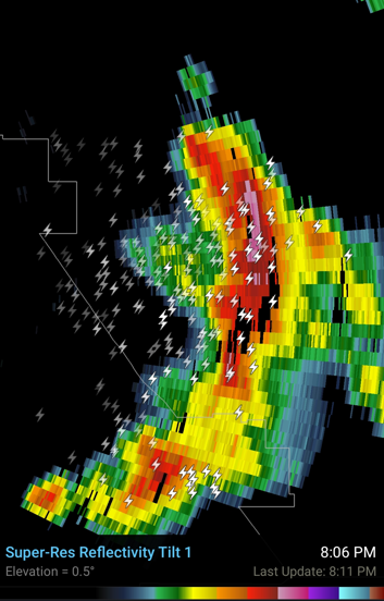
Whilst these storms weren’t severe warned, 3D radar scans detected hail of 2cm in the strongest cell east of Merredin.
Rainfall totals remained generally below 10mm for most locations, although Burracoppin South registered the highest total of 11mm.
Image 1: EWN lightning tracker.
![]() Image 2: South Doodlakine radar image – strong cores to the east of Merredin with 3D radar picking up 2cm hail. Image via RadarScope.
Image 2: South Doodlakine radar image – strong cores to the east of Merredin with 3D radar picking up 2cm hail. Image via RadarScope.
South East Queensland is on flood alert with a significant rain event developing.
A strong upper...
A wintry blast is set to sweep across southeast SA, Victoria and Tasmania on Tuesday and Wednesday...
Image 1: December Heat - Surface temperatures for Western Australia at 5:00pm 30th December 2020